
FCCInfo.com
A Service of Cavell, Mertz & Associates, Inc.
(855) FCC-INFO
|
|
WARU-FM from 07/13/1999 WARU-FM from 07/17/1998 |
|
|
||||||||||||||||
|
|
WARU-FM Channel: 270A 101.9 MHz Roann, Indiana Service: FM - A full-service FM station or application. Facility ID: 78254 Fac. Service: FM Status: LIC 73.215 Station Application Accepted: 02/27/2001 Application Granted: 03/14/2001 File Number: BLH-20010227AAR Prefix Type: This is a license for a commercial FM station Application Type: License To Cover FCC Website Links: LMS Facility Details This Application CDBS Application Other WARU-FM Applications Other WARU-FM Applications in CDBS Including Superseded Applications Mailing Address Correspondence for WARU-FM Correspondence related to application BLH-20010227AAR Service Contour - Open Street Map or USGS Map (60 dBu) Service Contour - KML / Google Earth (60 dBu) Public Inspection Files Facility Type: FM STATION Class: A, A Zone I; I-A; or II station; with 0.1kW-6kW ERP and a class contour distance <=28km Site Location: 40-48-30.2 N 85-56-07.0 W (NAD 83) Site Location: 40-48-30.0 N 85-56-07.0 W (Converted to NAD 27) Effective Radiated Power: 3.6 kW Transmitter Output Power: 4.334 kW Antenna Center HAAT: 129 m (423 ft.) Antenna Center AMSL: 354 m (1161 ft.) Antenna Center HAG: 116 m (381 ft.) Calculated Site Elevation: 238 m. (781 ft.) Height Overall*: 120 m (394 ft.) (* As Filed In This Application, may differ from ASR Data, Below.) Directional Antenna Antenna Make/Model: Electronics Research Inc. LP-2E-DA-HW Antenna ID: 15916 Polarization: | ||||||||||||||||||
| Antenna Data for Antenna Id: 15916 WARU-FM FM File: BLH-20010227AAR Electronics Research Inc. - LP-2E-DA-HW Service: FM | 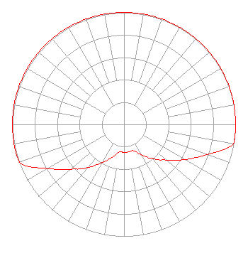 | ||||||||||||||||||
| Azimuth | Ratio | Azimuth | Ratio | Azimuth | Ratio | Azimuth | Ratio | ||||||||||||
| 0 | 1.000 | 10 | 1.000 | 20 | 1.000 | 30 | 1.000 | ||||||||||||
| 40 | 1.000 | 50 | 1.000 | 60 | 1.000 | 70 | 1.000 | ||||||||||||
| 80 | 1.000 | 90 | 1.000 | 100 | 0.995 | 110 | 0.791 | ||||||||||||
| 120 | 0.628 | 130 | 0.499 | 135 | 0.448 | 140 | 0.396 | ||||||||||||
| 150 | 0.315 | 160 | 0.250 | 170 | 0.250 | 180 | 0.250 | ||||||||||||
| 190 | 0.250 | 200 | 0.315 | 210 | 0.395 | 220 | 0.499 | ||||||||||||
| 225 | 0.564 | 230 | 0.628 | 240 | 0.791 | 250 | 0.995 | ||||||||||||
| 260 | 1.000 | 270 | 1.000 | 280 | 1.000 | 290 | 1.000 | ||||||||||||
| 300 | 1.000 | 310 | 1.000 | 320 | 1.000 | 330 | 1.000 | ||||||||||||
| 340 | 1.000 | 350 | 1.000 | ||||||||||||||||
Structure Registration Number 1201280 Structure Type: TOWER Registered To: Mid-America Radio Group, Inc. Structure Address: 1.05 Km West Of Intersection Of Roann Richvalley Rd. Richvalley, IN County Name: Wabash County ASR Issued: 08/10/1999 Date Built: 10/25/2000 Site Elevation: 237.7 m (780 ft.) Structure Height: 119.5 m (392 ft.) Height Overall: 120.4 m (395 ft.) Overall Height AMSL: 358.1 m (1175 ft.) FAA Determination: 05/17/1999 FAA Study #: 99-AGL-1787-OE FAA Circular #: 70/7460-1J Paint & Light FAA Chapters: 3, 4, 5, 13 Removed expiration date from determination. Scenario 1./jjs/case#635066 40-48-30.2 N 85-56-07.0 W (NAD 83) 40-48-30.0 N 85-56-07.0 W (Converted to NAD 27) |
1350 South Wabash Street Wabash, IN 46992 Phone: 260-571-0485 | Date: 02/27/2001 Application Certifier MID-AMERICA RADIO GROUP, INC. P.o. Box 1970 Martinsville, IN 46151 Applicant ROBERT B. LONGSHORE P.o. Box 2208 Kokomo, IN 46904-2208 CHIEF ENGINEER FRANK R. JAZZO, ESQUIRE Fletcher, Heald & Hildreth, P.l.c. | |||||||||||||||||
| |||||||||||||||||||