
FCCInfo.com
A Service of Cavell, Mertz & Associates, Inc.
(855) FCC-INFO
|
|
W244DV from 03/11/2004 |
|
|
||||||||||||||||
|
|
W244DV Channel: 244D 96.7 MHz Marysville, Ohio Service: FX - A translator or application for a translator. Facility ID: 141717 Fac. Service: FX Programming Delivery Method: Unspecified Status: LIC Application Accepted: 07/16/2019 Application Granted: 07/19/2019 File Number: BLFT-20190716AAS Prefix Type: This is a license for a translator Application Type: License To Cover FCC Website Links: LMS Facility Details This Application CDBS Application Other W244DV Applications Other W244DV Applications in CDBS Including Superseded Applications Mailing Address Correspondence for W244DV Correspondence related to application BLFT-20190716AAS Service Contour - Open Street Map or USGS Map (60 dBu) Service Contour - KML / Google Earth (60 dBu) Class: D, A Noncommercial educational operating with no more than 10W Site Location: 40-15-42.1 N 83-16-24.1 W (NAD 83) Site Location: 40-15-41.9 N 83-16-24.4 W (Converted to NAD 27) Effective Radiated Power: 0.25 kW Transmitter Output Power: 0.12 kW Antenna Center HAAT: 0 m Antenna Center AMSL: 372 m (1220 ft.) Antenna Center HAG: 70 m (230 ft.) Site Elevation: 302 m. (991 ft.) Height Overall*: 78 m (256 ft.) (* As Filed In This Application, may differ from ASR Data, Below.) Directional Antenna Antenna Make/Model: None Antenna ID: 16150 Polarization:
| ||||||||||||||||||
| Antenna Data for Antenna Id: 16150 W244DV FX File: BLFT-20190716AAS None - Service: FX Pattern and Field Values Include a 260° Clockwise Rotation | 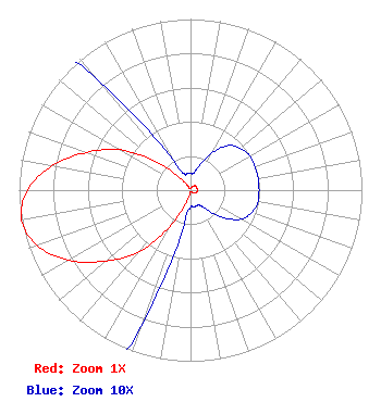 | ||||||||||||||||||
| Azimuth | Ratio | Azimuth | Ratio | Azimuth | Ratio | Azimuth | Ratio | ||||||||||||
| 0 | 0.010 | 10 | 0.010 | 20 | 0.015 | 30 | 0.025 | ||||||||||||
| 40 | 0.034 | 50 | 0.038 | 60 | 0.040 | 70 | 0.040 | ||||||||||||
| 80 | 0.040 | 90 | 0.040 | 100 | 0.040 | 110 | 0.038 | ||||||||||||
| 120 | 0.034 | 130 | 0.025 | 140 | 0.015 | 150 | 0.010 | ||||||||||||
| 160 | 0.010 | 170 | 0.010 | 180 | 0.010 | 190 | 0.020 | ||||||||||||
| 200 | 0.085 | 210 | 0.250 | 220 | 0.470 | 230 | 0.645 | ||||||||||||
| 240 | 0.820 | 250 | 0.950 | 260 | 1.000 | 270 | 0.950 | ||||||||||||
| 280 | 0.820 | 290 | 0.645 | 300 | 0.470 | 310 | 0.250 | ||||||||||||
| 320 | 0.085 | 330 | 0.020 | 340 | 0.010 | 350 | 0.010 | ||||||||||||
Structure Registration Number 1203877 [ASR Heights Differ from W244DV Application] Structure Type: 06/01/ Registered To: American Towers LLC Structure Address: Marysville Oh, 39 ASR Issued: 01/12/2016 Date Built: 04/03/2001 Site Elevation: 78 m (256 ft.) Structure Height: 301.8 m (990 ft.) Height Overall: 379.8 m (1246 ft.) FAA Determination: 2015-AGL-6 FAA Study #: 70/7460-1J FAA Circular #: 1 Paint & Light FAA Chapters: 7 40-15-42.1 N 83-16-24.1 W (NAD 83) 40-15-41.9 N 83-16-24.4 W (Converted to NAD 27) |
4001 Curve Road Delaware, OH 43015 Phone: 614-832-9156 | Date: 07/16/2019 Application Certifier DELMAR COMMUNICATIONS, INC. 4001 Curve Road Delaware, OH 43015 Applicant GARY E. LIEBISCH 7762 Maple Run Ln. Powell, OH 43065-8053 CONTRACT ENGINEER CARY S. TEPPER Tepper Law Firm, Llc 4900 Auburn Avenue Suite 100 Bethesda, MD 20814-2632 | |||||||||||||||||