FCCInfo.com
A Service of Cavell, Mertz & Associates, Inc.
(855) FCC-INFO
|
|
KEXI-LP from 07/17/2009 DKEXI-LP from 07/17/2009 KEXI-LP from 07/17/2009 DKEXI-LP from 07/17/2009 KEXI-LP from 12/06/2001 KMMF-LP from 11/28/2001 KEXI-LP from 12/13/1999 K35EZ from 01/12/1998 JD0415PV from 01/12/1998 |
|
|
|||||||||||||||||
|
|
Status: LIC Application Accepted: 12/02/2014 License Expires: 04/01/2030 File Number: BLDTL-20141202ABS Prefix Type: This is BLDTL FCC Website Links: LMS Facility Details This Application Other KEXI-LD Applications Including Superseded Applications Service Contour - Open Street Map or USGS Map (51 dBu) Service Contour - KML / Google Earth (51 dBu) Rabbit Ears Info Search for KEXI-LD Site Location: 48-10-33.9 N 114-21-00.2 W (NAD 83) Site Location: 48-10-34.1 N 114-20-56.7 W (Converted to NAD 27) ERP: 1 kW R/C AGL: 30.5 m (100 ft.) R/C AMSL: 1158.48 m (3801 ft.) Emission Mask: Stringent Site Elevation: 1128 m. (3701 ft.) Height Overall*: 52 m (171 ft.) (* As Filed In This Application, may differ from ASR Data, Below.) Directional Antenna - Antenna Make/Model: Kathrein 4DR-4-3HC Antenna ID: 120101
| |||||||||||||||||||
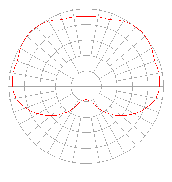
| Antenna Data for Antenna Id: 120101 KEXI-LD LD File: BLDTL-20141202ABS Kathrein - 4DR-4-3HC Service: LD Standard Pattern: Y |  | |||||||||||||||||||
| Azimuth | Ratio | Azimuth | Ratio | Azimuth | Ratio | Azimuth | Ratio | |||||||||||||
| 0 | 0.898 | 10 | 0.906 | 20 | 0.915 | 30 | 0.969 | |||||||||||||
| 40 | 0.996 | 50 | 1.000 | 60 | 0.977 | 70 | 0.946 | |||||||||||||
| 80 | 0.955 | 90 | 0.947 | 100 | 0.918 | 110 | 0.827 | |||||||||||||
| 120 | 0.711 | 130 | 0.592 | 140 | 0.461 | 150 | 0.335 | |||||||||||||
| 160 | 0.222 | 170 | 0.190 | 180 | 0.171 | 190 | 0.190 | |||||||||||||
| 200 | 0.222 | 210 | 0.335 | 220 | 0.461 | 230 | 0.592 | |||||||||||||
| 240 | 0.711 | 250 | 0.827 | 260 | 0.918 | 270 | 0.947 | |||||||||||||
| 280 | 0.955 | 290 | 0.946 | 300 | 0.977 | 310 | 1.000 | |||||||||||||
| 320 | 0.996 | 330 | 0.969 | 340 | 0.915 | 350 | 0.906 | |||||||||||||
Structure Registration Number 1004480 Structure Type: TOWER Registered To: WEESE, RAE SHIRLEEN DBA = WEESE ENTERPRISES Structure Address: Lone Pine Approx 2 Mi Sw Kalispell, MT County Name: Flathead County ASR Issued: 03/19/2010 Date Built: 01/01/1995 Site Elevation: 1128 m (3701 ft.) Structure Height: 46 m (151 ft.) Height Overall: 52 m (171 ft.) Overall Height AMSL: 1180 m (3871 ft.) FAA Determination: 02/02/2010 FAA Study #: 2010-ANM-45-OE FAA Circular #: 70/7460-1H Paint & Light FAA Chapters: 4, 5, 13 PRIOR STUDY 1994-ANM-976-OE 48-10-33.9 N 114-21-00.2 W (NAD 83) 48-10-34.1 N 114-20-56.7 W (Converted to NAD 27) |
Room 183, Visual Communications Building Bozeman, MT 59717 Phone: 406-994-3437 Government Entity | Date: 12/02/2014 Application Certifier Montana State University Room 183, VCB Bozeman, MT 59717-3340 Applicant Dean Lawver PO Box 173340 Bozeman, MT 59717 Director of Technology Margaret L. Miller Gray Miller Persh LLP | ||||||||||||||||||