FCCInfo.com
A Service of Cavell, Mertz & Associates, Inc.
(855) FCC-INFO
|
|
WGBP-TV from ??? WLGA from ??? WGBP from 09/03/2020 WLGA from 06/16/2005 WSWS-TV from 06/07/1982 WSWS from 02/25/1980 790307LC from ??? |
Virtual Channel 66 |  |
|
|||||||||||||||||
|
|
Status: LIC (Licensed And Reduced Power) Application Accepted: 08/27/2014 License Expires: 04/01/2029 File Number: BLCDT-20140827ABB Prefix Type: This is a License for a commercial digital TV station FCC Website Links: LMS Facility Details This Application Other WHOT-TV Applications Including Superseded Applications Service Contour - Open Street Map or USGS Map (41 dBu) Service Contour - KML / Google Earth (41 dBu) Public Inspection Files Rabbit Ears Info Search for WHOT-TV Site Location: 32-19-16.4 N 84-47-28.2 W (NAD 83) Site Location: 32-19-15.9 N 84-47-28.5 W (Converted to NAD 27) ERP: 500 kW Polarization: Horizontally polarized HAAT: 536 m (1759 ft.) Electrical Beam Tilt: 1 degree R/C AGL: 509 m (1670 ft.) R/C AMSL: 656.2 m (2153 ft.) Site Elevation: 147.2 m. (483 ft.) Height Overall*: 538.2 m (1766 ft.) (* As Filed In This Application, may differ from ASR Data, Below.) Directional Antenna - Antenna Make/Model: Electronics Research Inc. ATW24G475-HSS-30 Antenna ID: 118007 Polarization: Horizontally polarized | ||||||||||||||||||||
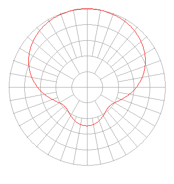
| Antenna Data for Antenna Id: 118007 WHOT-TV DT File: BLCDT-20140827ABB Electronics Research Inc. - ATW24G475-HSS-30 Service: DT Standard Pattern: Y |  | ||||||||||||||||||||
| Azimuth | Ratio | Azimuth | Ratio | Azimuth | Ratio | Azimuth | Ratio | ||||||||||||||
| 0 | 1.000 | 10 | 0.996 | 20 | 0.985 | 30 | 0.967 | ||||||||||||||
| 40 | 0.939 | 50 | 0.901 | 60 | 0.851 | 70 | 0.790 | ||||||||||||||
| 80 | 0.717 | 90 | 0.634 | 100 | 0.548 | 110 | 0.467 | ||||||||||||||
| 120 | 0.405 | 130 | 0.377 | 140 | 0.386 | 150 | 0.419 | ||||||||||||||
| 160 | 0.457 | 170 | 0.485 | 180 | 0.496 | 190 | 0.485 | ||||||||||||||
| 200 | 0.457 | 210 | 0.419 | 220 | 0.386 | 230 | 0.377 | ||||||||||||||
| 240 | 0.405 | 250 | 0.467 | 260 | 0.548 | 270 | 0.634 | ||||||||||||||
| 280 | 0.717 | 290 | 0.790 | 300 | 0.851 | 310 | 0.901 | ||||||||||||||
| 320 | 0.939 | 330 | 0.967 | 340 | 0.985 | 350 | 0.996 | ||||||||||||||
Structure Registration Number 1243417 Structure Type: GTOWER Registered To: American Towers LLC Structure Address: 135 Hwy. 26 Cusseta, GA County Name: Chattahoochee County ASR Issued: 04/22/2015 Date Built: 10/06/2005 Site Elevation: 147.2 m (483 ft.) Structure Height: 500.7 m (1643 ft.) Height Overall: 538.2 m (1766 ft.) Overall Height AMSL: 685.4 m (2249 ft.) FAA Determination: 06/29/2007 FAA Study #: 2007-ASO-2952-OE FAA Circular #: 70/7460-1K Paint & Light FAA Chapters: 4, 9, 12 PRIOR STUDY 2001-ASO-3028-OE 32-19-16.4 N 84-47-28.2 W (NAD 83) 32-19-15.9 N 84-47-28.5 W (Converted to NAD 27) |
15200 Sunset Blvd Suite 202 Pacific Palisades, CA 90272 Phone: 310-573-1600 Limited Liability Company | Date: 08/27/2014 Application Certifier Pappas Telecasting of Opelika, L.P. 823 West Center Avenue Visalia, CA 93291 Applicant Kevin T. Fisher 15640 Piedmont Place Woodbridge, VA 22193 Engineering Consultant Kathleen Victory Fletcher, Heald & Hildreth, PLC 1300 North 17th Street 11th Floor Arlington, VA 22209 | |||||||||||||||||||