|
KBAY(FM)
Call Sign History
KBAY from 09/23/2004
KBAA from 09/05/2003
DKBRG from 01/26/1998
KBRG from 01/26/1998
KBAY from 12/31/1997
KBRG from 12/31/1997
KBAY from 12/31/1997
KUFX from 03/04/1991
KWSS from 01/17/1983
KFAT from ???
|
94.5 MHz
|
Gilroy, CA
|
|
KBAY Channel: 233B 94.5 MHz
Gilroy, California
Service: FM - A full-service FM station or application.
Facility ID: 35401
FRN: 0022491476
Fac. Service: FM
Status: LIC
Application Accepted: 03/21/2011
Application Granted: 04/07/2011
File Number: BLH-20110321ACY
License Expires: 12/01/2029
Prefix Type: This is a license for a commercial FM station
Application Type: License To Cover
FCC Website Links:
LMS Facility Details
This Application
Other KBAY Applications
Including Superseded Applications
Service Contour - Open Street Map or USGS Map (54 dBu)
Service Contour - KML / Google Earth (54 dBu)
Public Inspection Files
Facility Type: FM STATION
Class: B, A Zone I or I-A station; with 25kW-50kW ERP and a class contour distance 39km-52km
Site Location: 37-12-31.8 N 121-46-30.8 W (NAD 83)
Site Location: 37-12-32.0 N 121-46-27.0 W (Converted to NAD 27)
Effective Radiated Power: 44 kW
Transmitter Output Power: 21 kW
Antenna Center HAAT: 158 m (518 ft.)
Antenna Center AMSL: 430 m (1411 ft.)
Antenna Center HAG: 85 m (279 ft.)
Calculated Site Elevation: 345 m. (1132 ft.)
Height Overall*: 92 m (302 ft.)
(* As Filed In This Application, may differ from ASR Data, Below.)
Directional Antenna
Antenna Make/Model: Electronics Research Inc. LP-6E-DA-HW-S, 6 sections, .5 wavelength spacing
Antenna ID: 83354
Polarization:
|
Antenna Data for Antenna Id: 83354
KBAY FM File: BLH-20110321ACY
Electronics Research Inc. - LP-6E-DA-HW-S, 6 sections, .5 wavelength spacing
Service: FM
|
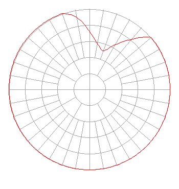 |
| Azimuth | Ratio | Azimuth | Ratio | Azimuth | Ratio | Azimuth | Ratio |
| 0 | 0.721 | 10 | 0.573 | 20 | 0.511 | 30 | 0.643 |
| 40 | 0.809 | 50 | 1.000 | 60 | 1.000 | 70 | 1.000 |
| 80 | 1.000 | 90 | 1.000 | 100 | 1.000 | 110 | 1.000 |
| 120 | 1.000 | 130 | 1.000 | 140 | 1.000 | 150 | 1.000 |
| 160 | 1.000 | 170 | 1.000 | 180 | 1.000 | 190 | 1.000 |
| 200 | 1.000 | 210 | 1.000 | 220 | 1.000 | 230 | 1.000 |
| 240 | 1.000 | 250 | 1.000 | 260 | 1.000 | 270 | 1.000 |
| 280 | 1.000 | 290 | 1.000 | 300 | 1.000 | 310 | 1.000 |
| 320 | 1.000 | 330 | 1.000 | 340 | 1.000 | 350 | 0.908 |
|
Structure Information
Structure Registration Number 1055723
Structure Type: LTOWER
Registered To:
American Towers LLC
Structure Address:
26060 Bernal Rd. (008113 / Coyote Peak)
San Jose, CA
County Name: Santa Clara County
ASR Issued: 12/30/2022
Date Built: 11/01/1996
Site Elevation: 345.3 m (1133 ft.)
Structure Height: 91.4 m (300 ft.)
Height Overall: 92 m (302 ft.)
Overall Height AMSL: 437.3 m (1435 ft.)
FAA Determination: 12/19/2022
FAA Study #: 2022-AWP-4871-OE
FAA Circular #: 70/7460-1K
Paint & Light FAA Chapters: 4, 6, 12
PRIOR STUDY 2015-AWP-7128-OE
37-12-32.1 N 121-46-31.0 W (NAD 83)
37-12-32.3 N 121-46-27.2 W
(Converted to NAD 27)
|
KBAY(FM) Licensee Information
Alpha Media Licensee LLC
180 Post Road East
Suite 201
Westport, CT 06880
Phone: 203-227-1978
Limited Liability Company | 20110321ACY Applicant Information
Matthew L. Leibowitz
Date: 03/21/2011
Application Certifier
NM Licensing LLC
6312 South Fiddlers Green Cir.
Suite 205-E
Greenwood Village, CO 80111
Applicant
Erik C. Swanson, P.E.
Hatfield & Dawson Consulting Engineers
9500 Greenwood Ave N
Seattle, WA 98103
Consulting Engineer
Joseph A. Belisle
Leibowitz & Associates
|
Associated Land Mobile Licenses
|
| | WPMV625 |
Broadcast Auxiliary Remote Pickup |
| Associated Microwave Licenses
|
| (No Records Found) |
|
