|
W261DD Channel: 261D 100.1 MHz
Springfield, Massachusetts
Service: FX - A translator or application for a translator.
Facility ID: 66424
FRN: 0006574347
Fac. Service: FX
Programming Delivery Method: Unspecified
Status: LIC
Application Accepted: 10/13/2016
Application Granted: 10/28/2016
File Number: BLFT-20161013AAK
License Expires: 04/01/2030
Prefix Type: This is a license for a translator
Application Type: License To Cover
FCC Website Links:
LMS Facility Details
This Application
Other W261DD Applications
Including Superseded Applications
Service Contour - Open Street Map or USGS Map (60 dBu)
Service Contour - KML / Google Earth (60 dBu)
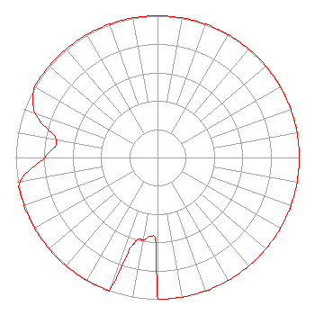
Class: D, A Noncommercial educational operating with no more than 10W
Site Location: 42-05-55.3 N 72-37-43.3 W (NAD 83)
Site Location: 42-05-55.0 N 72-37-45.0 W (Converted to NAD 27)
Effective Radiated Power: 0.25 kW
Transmitter Output Power: 0.163 kW
Antenna Center AMSL: 136 m (446 ft.)
Antenna Center HAG: 116 m (381 ft.)
Site Elevation: 20 m. (66 ft.)
Height Overall*: 122 m (400 ft.)
(* As Filed In This Application, may differ from ASR Data, Below.)
Directional Antenna
Antenna Make/Model: DIELECTRIC DCRT-6 HW
Antenna ID: 125175
Polarization:
| Primary Station |
| WACM(AM) |
Ch. 0 | Springfield, Massachusetts |
|
Structure Information
Structure Registration Number 1058191
Structure Type: TOWER
Registered To:
Red Wolf Broadcasting Corporation
Structure Address:
River Street
West Springfield, MA
County Name: Hampden County
ASR Issued: 02/05/2019
Date Built: 06/06/1986
Site Elevation: 19.8 m (65 ft.)
Structure Height: 121 m (397 ft.)
Height Overall: 121.9 m (400 ft.)
Overall Height AMSL: 141.7 m (465 ft.)
FAA Determination: 06/05/1986
FAA Study #: 86-ANE-235-OE
Paint & Light FAA Chapters: 1, 3, 12, 21
RED LIGHTS/PAINT
42-05-55.0 N 72-37-43.0 W (NAD 83)
42-05-54.7 N 72-37-44.7 W
(Converted to NAD 27)
|
W261DD(FX) Licensee Information
Red Wolf Broadcasting Corporation
756 Colonel Ledyard Highway
PO Box 357
Ledyard, CT 06339
Phone: 860-883-4292
| 20161013AAK Applicant Information
John Fuller
Date: 10/13/2016
Application Certifier
Red Wolf Broadcasting Corporation
758 Colonel Ledyard Highway
P.O. Box 357
Ledyard, CT 06339
Applicant
W. Jeffrey Reynolds
Du Treil, Lundin & Rackley, Inc.
201 Fletcher Avenue
Sarasota, FL 34237-6019
Technical Consultant
Scott Woodworth
Edinger Associates PLLC
1875 I Street NW
Suite 500
Washington, DC 20006
|