|
WVML(FM)
Call Sign History
WVML from 04/03/2002
|
90.5 MHz | 
|
Millersburg, OH
|
|
WVML Channel: 213B1 90.5 MHz
Millersburg, Ohio
Service: FM - A full-service FM station or application.
Facility ID: 85908
FRN: 0006791354
Fac. Service: FM
Status: LIC
Application Accepted: 04/03/2013
Application Granted: 04/17/2013
File Number: BLED-20130403AAD
License Expires: 10/01/2028
Prefix Type: This is a license for a noncommercial educational FM station
Application Type: License To Cover
FCC Website Links:
LMS Facility Details
This Application
Other WVML Applications
Including Superseded Applications
Service Contour - Open Street Map or USGS Map (60 dBu)
Service Contour - KML / Google Earth (60 dBu)
Public Inspection Files
Facility Type: NON-COMMERCIAL EDUC. FM
Class: B1, A Zone I or I-A station; with 6kW-25kW ERP and a class contour distance 28km-39km
Site Location: 40-36-08.2 N 81-44-31.5 W (NAD 83)
Site Location: 40-36-08.0 N 81-44-32.0 W (Converted to NAD 27)
Effective Radiated Power: 15 kW
Transmitter Output Power: 3.8 kW
Antenna Center HAAT: 112 m (367 ft.)
Antenna Center AMSL: 450 m (1476 ft.)
Antenna Center HAG: 55 m (180 ft.)
Calculated Site Elevation: 395 m. (1296 ft.)
Height Overall*: 60.6 m (199 ft.)
(* As Filed In This Application, may differ from ASR Data, Below.)
Directional Antenna
Antenna Make/Model: Jampro JCPD-2/3; six sections
Antenna ID: 96583
Polarization:
|
Antenna Data for Antenna Id: 96583
WVML FM File: BLED-20130403AAD
Jampro - JCPD-2/3; six sections
Service: FM
|
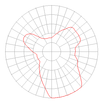 |
| Azimuth | Ratio | Azimuth | Ratio | Azimuth | Ratio | Azimuth | Ratio |
| 0 | 0.300 | 10 | 0.350 | 20 | 0.440 | 30 | 0.550 |
| 40 | 0.680 | 50 | 0.680 | 60 | 0.680 | 70 | 0.660 |
| 80 | 0.530 | 90 | 0.515 | 100 | 0.515 | 110 | 0.600 |
| 120 | 0.650 | 130 | 0.800 | 140 | 1.000 | 150 | 1.000 |
| 160 | 1.000 | 170 | 1.000 | 180 | 1.000 | 190 | 0.796 |
| 200 | 0.640 | 210 | 0.510 | 220 | 0.410 | 230 | 0.330 |
| 240 | 0.330 | 250 | 0.330 | 260 | 0.330 | 270 | 0.410 |
| 280 | 0.510 | 290 | 0.640 | 300 | 0.665 | 310 | 0.594 |
| 320 | 0.400 | 330 | 0.320 | 340 | 0.300 | 350 | 0.300 |
|
Structure Information
Structure Registration Number 1234190
Structure Type: TOWER
Registered To:
Moody Bible Institiute
Structure Address:
3391 Us Route 62
Millersburg, OH
County Name: Holmes County
ASR Issued: 02/09/2015
Date Built: 08/10/2005
Site Elevation: 394.7 m (1295 ft.)
Structure Height: 60.6 m (199 ft.)
Height Overall: 60.6 m (199 ft.)
Overall Height AMSL: 455.3 m (1494 ft.)
FAA Determination: 05/09/2002
FAA Study #: 02-AGL-1651-OE
Paint & Light FAA Chapters: NONE
40-36-08.2 N 81-44-31.5 W (NAD 83)
40-36-08.0 N 81-44-32.0 W
(Converted to NAD 27)
|
WVML(FM) Licensee Information
The Moody Bible Institute of Chicago
820 N Lasalle Boulevard
Chicago, IL 60610
Phone: 312-329-4290
Not-for-Profit | 20130403AAD Applicant Information
Elizabeth A.S. Brown
Date: 04/03/2013
Application Certifier
The Moody Bible Institute of Chicago
820 North Lasalle Boulevard
Chicago, IL 60610-3284
Applicant
Jeffrey D Southmayd
Southmayd & Miller
4 Ocean Ridge Boulevard South
Palm Coast, FL 32137
Attorney
Jeffrey D. Southmayd
Southmayd & Miller
|
Associated Land Mobile Licenses
|
| (No Records Found) |
| Associated Microwave Licenses
|
| (No Records Found) |
|
