FCCInfo.com
A Service of Cavell, Mertz & Associates, Inc.
(855) FCC-INFO
|
|
|
Virtual Channel 20 |  |
|
|||||||||||||||||||||||||||||||||
|
|
Status: LIC Application Accepted: 02/22/2012 License Expires: 08/01/2029 File Number: BXMLEDT-20120222ABH Prefix Type: This is BXMLEDT FCC Website Links: LMS Facility Details This Application Other WFYI Applications Including Superseded Applications Service Contour - Open Street Map or USGS Map (41 dBu) Service Contour - KML / Google Earth (41 dBu) Public Inspection Files Rabbit Ears Info Search for WFYI Site Location: 39-53-56.9 N 86-12-02.4 W (NAD 83) Site Location: 39-53-56.8 N 86-12-02.4 W (Converted to NAD 27) ERP: 200 kW Polarization: Horizontally polarized HAAT: 236 m (774 ft.) Electrical Beam Tilt: 1 degree R/C AGL: 238 m (781 ft.) R/C AMSL: 491 m (1611 ft.) Site Elevation: 253 m. (830 ft.) Height Overall*: 264.3 m (867 ft.) (* As Filed In This Application, may differ from ASR Data, Below.) Directional Antenna - Antenna Make/Model: DIELECTRIC TLP-160 C Antenna ID: 33405 Polarization: Horizontally polarized | ||||||||||||||||||||||||||||||||||||
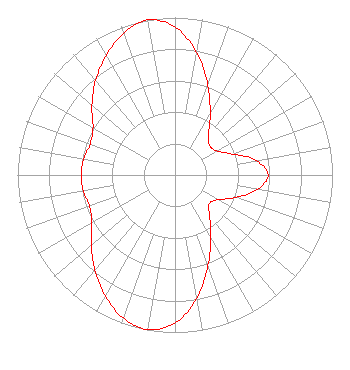
| Antenna Data for Antenna Id: 33405 WFYI DX File: BXMLEDT-20120222ABH DIELECTRIC - TLP-160 C Service: DX Standard Pattern: Y |  | ||||||||||||||||||||||||||||||||||||
| Azimuth | Ratio | Azimuth | Ratio | Azimuth | Ratio | Azimuth | Ratio | ||||||||||||||||||||||||||||||
| 0 | 0.939 | 10 | 0.790 | 20 | 0.607 | 30 | 0.447 | ||||||||||||||||||||||||||||||
| 40 | 0.329 | 50 | 0.288 | 60 | 0.307 | 70 | 0.389 | ||||||||||||||||||||||||||||||
| 80 | 0.525 | 90 | 0.591 | 100 | 0.532 | 110 | 0.415 | ||||||||||||||||||||||||||||||
| 120 | 0.314 | 130 | 0.284 | 140 | 0.341 | 150 | 0.455 | ||||||||||||||||||||||||||||||
| 160 | 0.612 | 170 | 0.794 | 180 | 0.939 | 190 | 0.998 | ||||||||||||||||||||||||||||||
| 200 | 0.965 | 210 | 0.885 | 220 | 0.791 | 230 | 0.693 | ||||||||||||||||||||||||||||||
| 240 | 0.610 | 250 | 0.578 | 260 | 0.592 | 270 | 0.596 | ||||||||||||||||||||||||||||||
| 280 | 0.588 | 290 | 0.574 | 300 | 0.601 | 310 | 0.689 | ||||||||||||||||||||||||||||||
| 320 | 0.784 | 330 | 0.876 | 340 | 0.958 | 350 | 1.000 | ||||||||||||||||||||||||||||||
Structure Registration Number 1027896 [ASR Heights Differ from WFYI Application] Structure Type: Registered To: METROPOLITAN INDIANAPOLIS PUBLIC MEDIA, INC. Structure Address: Twr 1 - 2300 W 79th St Indianapolis, IN County Name: Marion County ASR Issued: 10/02/2017 Date Built: 10/24/2018 Site Elevation: 253 m (830 ft.) Structure Height: 243.8 m (800 ft.) Height Overall: 267 m (876 ft.) Overall Height AMSL: 520 m (1706 ft.) FAA Determination: 12/11/2008 FAA Study #: 2008-AGL-5729-OE FAA Circular #: 70/7460-1K Paint & Light FAA Chapters: 3, 4, 5, 12 Removed expiration and final dates from determination. Scenario 2./jjs/case#635066 39-53-56.9 N 86-12-02.4 W (NAD 83) 39-53-56.8 N 86-12-02.4 W (Converted to NAD 27) |
C/O Steve Jensen 1630 North Meridian Street Indianapolis, IN 46202 Phone: 317-636-2020 Private Not-for-Profit Educational Institution | Date: 02/22/2012 Application Certifier Metropolitan Indianapolis Public Broadcasting, Inc. C/O Steve Jensen 1630 North Meridian Street Indianapolis, IN 46202 Applicant Donald J. Baad, Staff Engineer Munn-Reese, Inc. PO Box 220 - 385 Airport Drive Coldwater, MI 49036 Technical Consultant Matthew H. McCormick, Esquire Fletcher, Heald & Hildreth, PLC 1300 North 17th Street 11th Floor Arlington, VA 22209 | |||||||||||||||||||||||||||||||||||
| |||||||||||||||||||||||||||||||||||||