|
WJKS Channel: 282C3 104.3 MHz
Keeseville, New York
Service: FM - A full-service FM station or application.
Facility ID: 20606
FRN: 0013890413
Fac. Service: FM
Status: LIC
Application Accepted: 10/31/2014
Application Granted: 11/10/2014
File Number: BLH-20141031AAO
License Expires: 06/01/2030
Prefix Type: This is a license for a commercial FM station
Application Type: License To Cover
FCC Website Links:
LMS Facility Details
This Application
Other WJKS Applications
Including Superseded Applications
Service Contour - Open Street Map or USGS Map (60 dBu)
Service Contour - KML / Google Earth (60 dBu)
Public Inspection Files
Facility Type: FM STATION
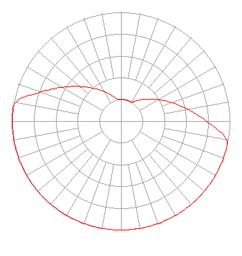
Class: C3, A Zone II station; with 6kW-25kW ERP and a class contour distance 28km-39km
Site Location: 44-31-31.8 N 73-31-07.3 W (NAD 83)
Site Location: 44-31-31.6 N 73-31-08.8 W (Converted to NAD 27)
Effective Radiated Power: 25 kW Horiz. ; 24.2 kW Vert.
Transmitter Output Power: 13.3 kW
Antenna Center HAAT: 88 m (289 ft.)
Antenna Center AMSL: 270 m (886 ft.)
Antenna Center HAG: 47 m (154 ft.)
Calculated Site Elevation: 223 m. (732 ft.)
Height Overall*: 77.7 m (255 ft.)
(* As Filed In This Application, may differ from ASR Data, Below.)
Directional Antenna
Antenna Make/Model: Shivley 6810-3-SS(0.5)-DA, 3 bay, 0.5 wavelength spaced
Antenna ID: 78729
Polarization:
|
Structure Information
Structure Registration Number 1010177
[ASR Heights Differ from WJKS Application]
Structure Type: LTOWER
Registered To:
American Towers LLC
Structure Address:
84 Deutsch Dr. (088134)
Keeseville, NY
County Name: Clinton County
ASR Issued: 04/03/2024
Date Built: 12/16/1965
Site Elevation: 222.5 m (730 ft.)
Structure Height: 72.5 m (238 ft.)
Height Overall: 77.7 m (255 ft.)
Overall Height AMSL: 300.2 m (985 ft.)
FAA Determination: 10/11/2023
FAA Study #: 2023-AEA-10144-OE
FAA Circular #: 70/7460-1K
Paint & Light FAA Chapters: 4, 8, 12
PRIOR STUDY 2011-AEA-346-OE
44-31-31.9 N 73-31-07.3 W (NAD 83)
44-31-31.7 N 73-31-08.8 W
(Converted to NAD 27)
|
WJKS(FM) Licensee Information
Great Eastern Radio, LLC
106 North Main Street
West Lebanon, NH 03766
Phone: 603-359-7110
Limited Liability Company | 20141031AAO Applicant Information
Gail C. Goddard
Date: 10/31/2014
Application Certifier
Electromagnetic Company, LLC
176 Pennywise Lane
Glastonbury, CT 06033
Applicant
Robert M. Smith Jr.
R.M. Smith Associates
P.O. Box 345
Jensen Beach, FL 34958
Technical Consultant
David G. O'Neil, Esq.
Rini O'Neil, PC
|