FCCInfo.com
A Service of Cavell, Mertz & Associates, Inc.
(855) FCC-INFO
|
|
KPXK from 07/01/1998 KBGB from 06/01/1998 961001YI from ??? |
Virtual Channel 30 |
|
||||||||||||||||||
|
|
Status: LIC Application Accepted: 06/12/2009 License Expires: 08/01/2030 File Number: BLCDT-20090612AJT Prefix Type: This is a License for a commercial digital TV station FCC Website Links: LMS Facility Details This Application Other KWWT Applications Including Superseded Applications Service Contour - Open Street Map or USGS Map (41 dBu) Service Contour - KML / Google Earth (41 dBu) Public Inspection Files Rabbit Ears Info Search for KWWT Site Location: 32-02-52.9 N 102-17-45.5 W (NAD 83) Site Location: 32-02-52.5 N 102-17-44.0 W (Converted to NAD 27) ERP: 50 kW Polarization: Horizontally polarized HAAT: 147 m (482 ft.) R/C AGL: 148 m (486 ft.) R/C AMSL: 1037.1 m (3403 ft.) Site Elevation: 889.1 m. (2917 ft.) Height Overall*: 152.1 m (499 ft.) (* As Filed In This Application, may differ from ASR Data, Below.) Directional Antenna - Antenna Make/Model: SBP UP-8-MEC Antenna ID: 89118 Polarization: Horizontally polarized | ||||||||||||||||||||
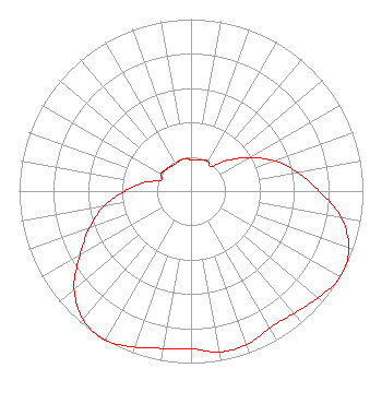
| Antenna Data for Antenna Id: 89118 KWWT DT File: BLCDT-20090612AJT SBP - UP-8-MEC Service: DT Standard Pattern: Y |  | ||||||||||||||||||||
| Azimuth | Ratio | Azimuth | Ratio | Azimuth | Ratio | Azimuth | Ratio | ||||||||||||||
| 0 | 0.183 | 10 | 0.185 | 20 | 0.193 | 30 | 0.200 | ||||||||||||||
| 40 | 0.185 | 50 | 0.278 | 60 | 0.387 | 70 | 0.516 | ||||||||||||||
| 80 | 0.629 | 90 | 0.747 | 100 | 0.887 | 110 | 0.977 | ||||||||||||||
| 120 | 1.000 | 130 | 0.965 | 140 | 0.929 | 150 | 0.917 | ||||||||||||||
| 160 | 0.950 | 170 | 0.950 | 180 | 0.917 | 190 | 0.929 | ||||||||||||||
| 200 | 0.965 | 210 | 1.000 | 220 | 0.977 | 230 | 0.887 | ||||||||||||||
| 240 | 0.747 | 250 | 0.629 | 260 | 0.516 | 270 | 0.387 | ||||||||||||||
| 280 | 0.278 | 290 | 0.185 | 300 | 0.200 | 310 | 0.193 | ||||||||||||||
| 320 | 0.186 | 330 | 0.183 | 340 | 0.190 | 350 | 0.190 | ||||||||||||||
Structure Registration Number 1210156 [ASR Heights Differ from KWWT Application] Structure Type: GTOWER Registered To: Gray Local Media, Inc. Structure Address: 2 Km West Of Junction Of State Roads #158 And #1788, Ector County, Near Odessa, TX County Name: Ector County ASR Issued: 08/26/2024 Date Built: 07/07/1988 Site Elevation: 893.1 m (2930 ft.) Structure Height: 152.1 m (499 ft.) Height Overall: 152.1 m (499 ft.) Overall Height AMSL: 1045.2 m (3429 ft.) FAA Determination: 08/31/1994 FAA Study #: 1994-ASW-844-OE FAA Circular #: 70/7460-1G Paint & Light FAA Chapters: 3, 4, 5, 9 32-02-52.5 N 102-18-12.5 W (NAD 83) 32-02-52.1 N 102-18-11.0 W (Converted to NAD 27) |
4370 Peachtree Road, NE Atlanta, GA 30319 Phone: 404-504-9828 Limited Liability Company | Date: 06/12/2009 Application Certifier Winstar Odessa, Inc. PO Box 547 Arroyo Grande, CA 93421 Applicant James L. Primm James L. Primm Attorney at Law PO Box 547 Arroyo Grande, CA 93421 President James L. Primm James L. Primm Atty.at Law PO Box 547 Arroyo Grande, CA 93421 | |||||||||||||||||||