FCCInfo.com
A Service of Cavell, Mertz & Associates, Inc.
(855) FCC-INFO
|
|
K51JN-D from 01/12/2007 |
|
|
||||||||||||||||
|
|
Status: LIC (Licensed And Silent) Application Accepted: 10/08/2009 License Expires: 08/01/2022 File Number: BLDTL-20091008ACG Prefix Type: This is BLDTL FCC Website Links: LMS Facility Details This Application Other KXAD-LD Applications Including Superseded Applications Service Contour - Open Street Map or USGS Map (51 dBu) Service Contour - KML / Google Earth (51 dBu) Rabbit Ears Info Search for KXAD-LD Site Location: 35-15-41.6 N 101-52-53.8 W (NAD 83) Site Location: 35-15-41.4 N 101-52-52.1 W (Converted to NAD 27) ERP: 0.5 kW R/C AGL: 130.4 m (428 ft.) R/C AMSL: 1218.4 m (3997 ft.) Emission Mask: Stringent Site Elevation: 1088 m. (3570 ft.) Height Overall*: 135.3 m (444 ft.) (* As Filed In This Application, may differ from ASR Data, Below.) Directional Antenna - Antenna Make/Model: Scala 4DR-16-2HW Antenna ID: 20732 | ||||||||||||||||||
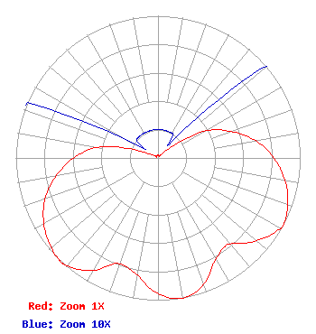
| Antenna Data for Antenna Id: 20732 KXAD-LD LD File: BLDTL-20091008ACG Scala - 4DR-16-2HW Service: LD Standard Pattern: Y Pattern and Field Values Include a 171° Clockwise Rotation |  | ||||||||||||||||||
| Azimuth | Ratio | Azimuth | Ratio | Azimuth | Ratio | Azimuth | Ratio | ||||||||||||
| 1 | 0.020 | 11 | 0.020 | 21 | 0.020 | 31 | 0.020 | ||||||||||||
| 41 | 0.020 | 51 | 0.130 | 61 | 0.395 | 71 | 0.560 | ||||||||||||
| 81 | 0.710 | 91 | 0.825 | 101 | 0.915 | 111 | 0.975 | ||||||||||||
| 118 | 1.000 | 121 | 0.983 | 131 | 0.895 | 141 | 0.784 | ||||||||||||
| 151 | 0.827 | 161 | 0.955 | 171 | 1.000 | 181 | 0.945 | ||||||||||||
| 191 | 0.830 | 201 | 0.795 | 211 | 0.925 | 221 | 0.995 | ||||||||||||
| 224 | 1.000 | 231 | 0.975 | 241 | 0.920 | 251 | 0.835 | ||||||||||||
| 261 | 0.715 | 271 | 0.580 | 281 | 0.410 | 291 | 0.135 | ||||||||||||
| 301 | 0.020 | 311 | 0.020 | 321 | 0.020 | 331 | 0.020 | ||||||||||||
| 341 | 0.020 | 351 | 0.020 | ||||||||||||||||
Structure Registration Number 1044767 Structure Type: GTOWER Registered To: American Towers LLC Structure Address: 19374 Vertical Partners (amarillo 1b #4336) Amarillo, TX County Name: Potter County ASR Issued: 09/26/2024 Date Built: 09/17/2012 Site Elevation: 1088.4 m (3571 ft.) Structure Height: 134.4 m (441 ft.) Height Overall: 135.3 m (444 ft.) Overall Height AMSL: 1223.7 m (4015 ft.) FAA Determination: 05/15/2024 FAA Study #: 2024-ASW-6235-OE FAA Circular #: 70/7460-1K Paint & Light FAA Chapters: 4, 8, 12 PRIOR STUDIES 2004-ASW-4525-OE / 2015-ASW-8703-OE 35-15-41.6 N 101-52-53.8 W (NAD 83) 35-15-41.4 N 101-52-52.1 W (Converted to NAD 27) |
Bedford, TX 76021 Phone: 361-883-1763 Individual | Date: 10/08/2009 Application Certifier Michael Mintz 518 Peoples St Corpus Christi, TX 78401 Applicant Henry Turner 5109 Cascade Dr. Corpus Christi, TX 78413 Engineer Lee Peltzman Shainis & Peltzman | |||||||||||||||||