FCCInfo.com
A Service of Cavell, Mertz & Associates, Inc.
(855) FCC-INFO
|
|
KLPB from ??? |
Virtual Channel 24 |
|
||||||||||||||||||
|
|
Status: LIC Application Accepted: 08/20/2013 License Expires: 06/01/2029 File Number: BLEDT-20130820AAH Prefix Type: This is a license for a noncommercial educational digital TV station FCC Website Links: LMS Facility Details This Application Other KLPB-TV Applications Including Superseded Applications Service Contour - Open Street Map or USGS Map (41 dBu) Service Contour - KML / Google Earth (41 dBu) Public Inspection Files Rabbit Ears Info Search for KLPB-TV Site Location: 30-19-20.0 N 92-16-59.0 W (NAD 83) Site Location: 30-19-19.3 N 92-16-58.5 W (Converted to NAD 27) ERP: 137.4 kW Polarization: Horizontally polarized HAAT: 463.2 m (1520 ft.) Electrical Beam Tilt: 1 degree R/C AGL: 465 m (1526 ft.) R/C AMSL: 473.2 m (1552 ft.) Site Elevation: 8.2 m. (27 ft.) Height Overall*: 541 m (1775 ft.) (* As Filed In This Application, may differ from ASR Data, Below.) Directional Antenna - Antenna Make/Model: DIELECTRIC TFU-10DSC C170 Antenna ID: 108059 Polarization: Horizontally polarized | ||||||||||||||||||||
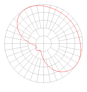
| Antenna Data for Antenna Id: 108059 KLPB-TV DT File: BLEDT-20130820AAH DIELECTRIC - TFU-10DSC C170 Service: DT Standard Pattern: Y |  | ||||||||||||||||||||
| Azimuth | Ratio | Azimuth | Ratio | Azimuth | Ratio | Azimuth | Ratio | ||||||||||||||
| 0 | 0.957 | 10 | 0.932 | 20 | 0.914 | 30 | 0.904 | ||||||||||||||
| 40 | 0.900 | 50 | 0.899 | 60 | 0.901 | 70 | 0.907 | ||||||||||||||
| 80 | 0.920 | 90 | 0.941 | 100 | 0.968 | 110 | 0.992 | ||||||||||||||
| 120 | 1.000 | 130 | 0.981 | 140 | 0.925 | 150 | 0.832 | ||||||||||||||
| 160 | 0.706 | 170 | 0.558 | 180 | 0.407 | 190 | 0.280 | ||||||||||||||
| 200 | 0.210 | 210 | 0.211 | 220 | 0.236 | 230 | 0.244 | ||||||||||||||
| 240 | 0.227 | 250 | 0.205 | 260 | 0.229 | 270 | 0.326 | ||||||||||||||
| 280 | 0.466 | 290 | 0.619 | 300 | 0.760 | 310 | 0.874 | ||||||||||||||
| 320 | 0.952 | 330 | 0.992 | 339 | 1.000 | 340 | 0.999 | ||||||||||||||
| 350 | 0.983 | ||||||||||||||||||||
Structure Registration Number 1060744 Structure Type: Registered To: Young Broadcasting of Louisiana, Inc. Structure Address: Phillips Rd At Florida Rd, 2mi S Of Branch, La Branch, LA County Name: Acadia Parish ASR Issued: 08/12/2014 Date Built: 07/11/2000 Site Elevation: 8.2 m (27 ft.) Structure Height: 499 m (1637 ft.) Height Overall: 541 m (1775 ft.) Overall Height AMSL: 549.2 m (1802 ft.) FAA Determination: 11/20/1998 FAA Study #: 98-ASW-3704-OE FAA Circular #: 70/7460-1J Paint & Light FAA Chapters: 4, 7, 13 Removed expiration and final dates from determination. Scenario 2./jjs/case#635066 30-19-20.0 N 92-16-59.0 W (NAD 83) 30-19-19.3 N 92-16-58.5 W (Converted to NAD 27) |
7733 Perkins Road Baton Rouge, LA 70810 Phone: 225-767-4273 Government Entity | Date: 08/20/2013 Application Certifier Louisiana Educational Television Authority 7733 Perkins Road Baton Rouge, LA 70810 Applicant Mark Wilson 7733 Perkins Road Baton Route, LA 70810 Transmitter Site Engineer Steven C. Schaffer Schwartz, Woods & Miller | |||||||||||||||||||