FCCInfo.com
A Service of Cavell, Mertz & Associates, Inc.
(855) FCC-INFO
|
|
KPVI from ??? |
Virtual Channel 6 |  |
|
||||||||||||||||||||||||||||||||||||||
|
|
Status: LIC Application Accepted: 07/06/2006 License Expires: 10/01/2030 File Number: BLCDT-20060706AEF Prefix Type: This is a License for a commercial digital TV station FCC Website Links: LMS Facility Details This Application Other KPVI-DT Applications Including Superseded Applications Service Contour - Open Street Map or USGS Map (41 dBu) Service Contour - KML / Google Earth (41 dBu) Public Inspection Files Rabbit Ears Info Search for KPVI-DT Site Location: 42-55-12.5 N 112-20-47.6 W (NAD 83) Site Location: 42-55-12.8 N 112-20-44.7 W (Converted to NAD 27) ERP: 505 kW Polarization: Horizontally polarized HAAT: 398.4 m (1307 ft.) Electrical Beam Tilt: 0.75 degrees R/C AGL: 102.9 m (338 ft.) R/C AMSL: 2003.9 m (6574 ft.) Site Elevation: 1901 m. (6237 ft.) Height Overall*: 110.3 m (362 ft.) (* As Filed In This Application, may differ from ASR Data, Below.) Directional Antenna - Antenna Make/Model: DIELECTRIC TFU-24JTH-R-S-260 Antenna ID: 73086 Polarization: Horizontally polarized
| |||||||||||||||||||||||||||||||||||||||||
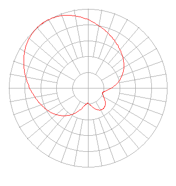
| Antenna Data for Antenna Id: 73086 KPVI-DT DT File: BLCDT-20060706AEF DIELECTRIC - TFU-24JTH-R-S-260 Service: DT Standard Pattern: Y |  | |||||||||||||||||||||||||||||||||||||||||
| Azimuth | Ratio | Azimuth | Ratio | Azimuth | Ratio | Azimuth | Ratio | |||||||||||||||||||||||||||||||||||
| 0 | 0.864 | 10 | 0.799 | 20 | 0.737 | 30 | 0.680 | |||||||||||||||||||||||||||||||||||
| 40 | 0.628 | 50 | 0.578 | 60 | 0.523 | 70 | 0.458 | |||||||||||||||||||||||||||||||||||
| 80 | 0.382 | 90 | 0.297 | 100 | 0.222 | 109 | 0.193 | |||||||||||||||||||||||||||||||||||
| 110 | 0.194 | 120 | 0.229 | 130 | 0.285 | 140 | 0.321 | |||||||||||||||||||||||||||||||||||
| 150 | 0.321 | 160 | 0.285 | 170 | 0.229 | 180 | 0.194 | |||||||||||||||||||||||||||||||||||
| 181 | 0.193 | 190 | 0.222 | 200 | 0.297 | 210 | 0.382 | |||||||||||||||||||||||||||||||||||
| 220 | 0.458 | 230 | 0.523 | 240 | 0.578 | 250 | 0.628 | |||||||||||||||||||||||||||||||||||
| 260 | 0.680 | 270 | 0.737 | 280 | 0.799 | 290 | 0.864 | |||||||||||||||||||||||||||||||||||
| 300 | 0.924 | 310 | 0.971 | 320 | 0.996 | 324 | 1.000 | |||||||||||||||||||||||||||||||||||
| 325 | 1.000 | 326 | 1.000 | 330 | 0.996 | 340 | 0.971 | |||||||||||||||||||||||||||||||||||
| 350 | 0.924 | |||||||||||||||||||||||||||||||||||||||||
Structure Registration Number 1248120 Structure Type: Registered To: VB-S1 Assets, LLC Structure Address: 5 Miles Ne Of Pocatello, ID County Name: Bannock County ASR Issued: 01/31/2018 Date Built: 09/21/2010 Site Elevation: 1901.3 m (6238 ft.) Structure Height: 94.5 m (310 ft.) Height Overall: 110.3 m (362 ft.) Overall Height AMSL: 2011.6 m (6600 ft.) FAA Determination: 09/13/2010 FAA Study #: 2010-ANM-1917-OE Paint & Light FAA Chapters: NONE PRIOR STUDY 2005-ANM-581-OE 42-55-12.5 N 112-20-47.6 W (NAD 83) 42-55-12.8 N 112-20-44.7 W (Converted to NAD 27) |
3000 Worldreach Drive Indian Land, SC 29707 Phone: 803-578-1418 Limited Liability Company | Date: 07/06/2006 Application Certifier Oregon Trail Broadcasting Company 1500 Foremaster Lane Las Vegas, NV 89101 Applicant Frank Haynes 1500 Foremaster Lane Las Vegas, NV 89101 Director of Engineering Jonathan Lichstein 1500 Foremaster Ln. Las Vegas, NV 89101 | ||||||||||||||||||||||||||||||||||||||||
| ||||||||||||||||||||||||||||||||||||||||||