FCCInfo.com
A Service of Cavell, Mertz & Associates, Inc.
(855) FCC-INFO
|
|
|
Virtual Channel 13 |  |
|
|||||||||||||||||||||||||||
|
|
Status: LIC Application Accepted: 02/20/2009 License Expires: 02/01/2029 File Number: BLCDT-20090220AAF Prefix Type: This is a License for a commercial digital TV station FCC Website Links: LMS Facility Details This Application Other WMBB Applications Including Superseded Applications Service Contour - Open Street Map or USGS Map (36 dBu) Service Contour - KML / Google Earth (36 dBu) Public Inspection Files Rabbit Ears Info Search for WMBB Site Location: 30-21-09.0 N 85-23-28.0 W (NAD 83) Site Location: 30-21-08.3 N 85-23-28.3 W (Converted to NAD 27) ERP: 42 kW Polarization: Horizontally polarized HAAT: 434 m (1424 ft.) Electrical Beam Tilt: 0.75 degrees R/C AGL: 438 m (1437 ft.) R/C AMSL: 462 m (1516 ft.) Site Elevation: 24 m. (79 ft.) Height Overall*: 446.7 m (1466 ft.) (* As Filed In This Application, may differ from ASR Data, Below.) Directional Antenna - Antenna Make/Model: DIELECTRIC THV-10A13-C170 Antenna ID: 85964 Polarization: Horizontally polarized | ||||||||||||||||||||||||||||||
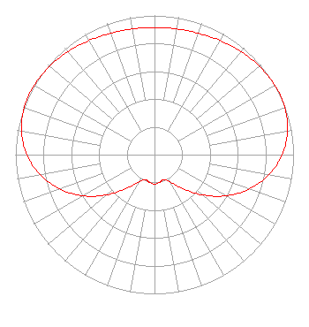
| Antenna Data for Antenna Id: 85964 WMBB DT File: BLCDT-20090220AAF DIELECTRIC - THV-10A13-C170 Service: DT Standard Pattern: Y |  | ||||||||||||||||||||||||||||||
| Azimuth | Ratio | Azimuth | Ratio | Azimuth | Ratio | Azimuth | Ratio | ||||||||||||||||||||||||
| 0 | 0.912 | 10 | 0.917 | 20 | 0.928 | 30 | 0.946 | ||||||||||||||||||||||||
| 40 | 0.967 | 50 | 0.987 | 60 | 0.999 | 64 | 1.000 | ||||||||||||||||||||||||
| 70 | 0.996 | 80 | 0.971 | 90 | 0.918 | 100 | 0.834 | ||||||||||||||||||||||||
| 110 | 0.723 | 120 | 0.591 | 130 | 0.450 | 140 | 0.320 | ||||||||||||||||||||||||
| 150 | 0.226 | 160 | 0.193 | 170 | 0.203 | 180 | 0.212 | ||||||||||||||||||||||||
| 190 | 0.203 | 200 | 0.193 | 210 | 0.226 | 220 | 0.320 | ||||||||||||||||||||||||
| 230 | 0.450 | 240 | 0.591 | 250 | 0.723 | 260 | 0.834 | ||||||||||||||||||||||||
| 270 | 0.918 | 280 | 0.971 | 290 | 0.996 | 296 | 1.000 | ||||||||||||||||||||||||
| 300 | 0.999 | 310 | 0.987 | 320 | 0.967 | 330 | 0.946 | ||||||||||||||||||||||||
| 340 | 0.928 | 350 | 0.917 | ||||||||||||||||||||||||||||
Structure Registration Number 1043251 Structure Type: GTOWER Registered To: Nexstar Media Inc. Structure Address: 13735 Scotts Ferry Road Youngstown, FL County Name: Bay County ASR Issued: 04/27/2022 Date Built: 08/01/1990 Site Elevation: 24 m (79 ft.) Structure Height: 427.7 m (1403 ft.) Height Overall: 446.7 m (1466 ft.) Overall Height AMSL: 470.7 m (1544 ft.) FAA Determination: 04/21/2022 FAA Study #: 2022-ASO-2145-OE FAA Circular #: 70/7460-1M Paint & Light FAA Chapters: 4, 9, 15 PRIOR STUDY 1997-ASO-5112-OE 30-21-09.0 N 85-23-28.0 W (NAD 83) 30-21-08.3 N 85-23-28.3 W (Converted to NAD 27) |
545 E. John Carpenter Freeway Suite 700 Irving, TX 75062 Phone: 972-373-8800 Corporation | Date: 02/20/2009 Application Certifier Hoak Media of Panama City License, LLC 500 Crescent Court Suite 220 Dallas, TX 75201 Applicant Laurence L Richesin 613 Harrison Ave. Panama City, FL 32401 Station Chief Engineer Tom W. Davidson, Esq. Akin Gump Strauss Hauer & Feld LLP 1333 New Hampshire Ave., N.W. Washington, DC 20036 | |||||||||||||||||||||||||||||
| |||||||||||||||||||||||||||||||