FCCInfo.com
A Service of Cavell, Mertz & Associates, Inc.
(855) FCC-INFO
|
|
WCJB from 01/29/1982 WCJB-TV from 01/12/1982 |
Virtual Channel 20 |  |
|
||||||||||||||||||||||||||||||
|
|
Status: LIC Application Accepted: 11/19/2007 License Expires: 02/01/2029 File Number: BLCDT-20071119AJB Prefix Type: This is a License for a commercial digital TV station FCC Website Links: LMS Facility Details This Application Other WCJB-TV Applications Including Superseded Applications Service Contour - Open Street Map or USGS Map (41 dBu) Service Contour - KML / Google Earth (41 dBu) Public Inspection Files Rabbit Ears Info Search for WCJB-TV Site Location: 29-32-12.0 N 82-23-59.0 W (NAD 83) Site Location: 29-32-11.1 N 82-23-59.6 W (Converted to NAD 27) ERP: 343.6 kW Polarization: Horizontally polarized HAAT: 254.4 m (835 ft.) R/C AGL: 259.1 m (850 ft.) R/C AMSL: 279.1 m (916 ft.) Site Elevation: 20 m. (66 ft.) Height Overall*: 300 m (984 ft.) (* As Filed In This Application, may differ from ASR Data, Below.) Directional Antenna - Antenna Make/Model: DIELECTRIC TFU-24DSB-O Antenna ID: 75840 Polarization: Horizontally polarized
| |||||||||||||||||||||||||||||||||
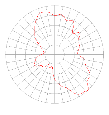
| Antenna Data for Antenna Id: 75840 WCJB-TV DT File: BLCDT-20071119AJB DIELECTRIC - TFU-24DSB-O Service: DT Standard Pattern: Y |  | |||||||||||||||||||||||||||||||||
| Azimuth | Ratio | Azimuth | Ratio | Azimuth | Ratio | Azimuth | Ratio | |||||||||||||||||||||||||||
| 0 | 0.800 | 10 | 0.820 | 20 | 0.737 | 30 | 0.771 | |||||||||||||||||||||||||||
| 40 | 0.570 | 50 | 0.677 | 60 | 0.553 | 70 | 0.541 | |||||||||||||||||||||||||||
| 80 | 0.497 | 90 | 0.477 | 100 | 0.617 | 110 | 0.681 | |||||||||||||||||||||||||||
| 120 | 0.836 | 130 | 0.869 | 137 | 1.000 | 140 | 0.981 | |||||||||||||||||||||||||||
| 150 | 0.937 | 160 | 0.733 | 170 | 0.635 | 180 | 0.503 | |||||||||||||||||||||||||||
| 190 | 0.257 | 200 | 0.292 | 210 | 0.234 | 220 | 0.339 | |||||||||||||||||||||||||||
| 230 | 0.353 | 240 | 0.467 | 250 | 0.422 | 260 | 0.365 | |||||||||||||||||||||||||||
| 270 | 0.258 | 278 | 0.214 | 280 | 0.218 | 290 | 0.260 | |||||||||||||||||||||||||||
| 300 | 0.333 | 310 | 0.510 | 320 | 0.628 | 330 | 0.770 | |||||||||||||||||||||||||||
| 340 | 0.886 | 350 | 0.880 | |||||||||||||||||||||||||||||||
Structure Registration Number 1035360 [ASR Heights Differ from WCJB-TV Application] Structure Type: TOWER Registered To: Gray Local Media, Inc. Structure Address: 1.35 Miles South Of Wacahoota, FL County Name: Alachua County ASR Issued: 08/26/2024 Date Built: 09/01/1982 Site Elevation: 19.5 m (64 ft.) Structure Height: 281.7 m (924 ft.) Height Overall: 299.5 m (983 ft.) Overall Height AMSL: 319 m (1047 ft.) FAA Determination: 10/23/1997 FAA Study #: 97-ASO-4541-OE FAA Circular #: 70/7460-1J Paint & Light FAA Chapters: 4, 7, 13 29-32-12.0 N 82-23-59.0 W (NAD 83) 29-32-11.1 N 82-23-59.6 W (Converted to NAD 27) |
4370 Peachtree Road, NE Atlanta, GA 30319 Phone: 404-504-9828 Limited Liability Company | Date: 11/19/2007 Application Certifier Diversified Broadcasting, Inc. 6220 NW 43rd Street Gainesville, FL 32653 Applicant Steve Ingram 6220 N.W. 43rd Street Gainesville, FL 32653 Chief Engineer Alan C. Campbell Irwin, Campbell & Tannenwald, P.C. 1730 Rhode Island Ave., NW Suite 200 Washington, DC 20036-3101 | ||||||||||||||||||||||||||||||||
|
| |||||||||||||||||||||||||||||||||