FCCInfo.com
A Service of Cavell, Mertz & Associates, Inc.
(855) FCC-INFO
|
|
WNYF-LD from 05/15/2013 WNYF-CD from 08/25/2008 |
|  |
|
|||||||||||||||
|
|
Status: LIC Application Accepted: 09/24/2009 License Expires: 06/01/2031 File Number: BLDTL-20090924ABW Prefix Type: This is BLDTL FCC Website Links: LMS Facility Details This Application Other WNYF-CD Applications Including Superseded Applications Service Contour - Open Street Map or USGS Map (51 dBu) Service Contour - KML / Google Earth (51 dBu) Public Inspection Files Rabbit Ears Info Search for WNYF-CD Site Location: 43-57-15.0 N 75-43-44.0 W (NAD 83) Site Location: 43-57-14.8 N 75-43-45.3 W (Converted to NAD 27) ERP: 15 kW Electrical Beam Tilt: 0.75 degrees R/C AGL: 150.2 m (493 ft.) R/C AMSL: 484.3 m (1589 ft.) Emission Mask: Stringent Site Elevation: 334.1 m. (1096 ft.) Height Overall*: 181.7 m (596 ft.) (* As Filed In This Application, may differ from ASR Data, Below.) Directional Antenna - Antenna Make/Model: Andrew ATW18H3-HSC2-35S Antenna ID: 76489 | ||||||||||||||||||
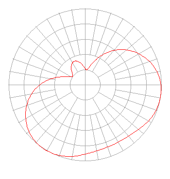
| Antenna Data for Antenna Id: 76489 WNYF-CD DC File: BLDTL-20090924ABW Andrew - ATW18H3-HSC2-35S Service: DC Standard Pattern: Y |  | ||||||||||||||||||
| Azimuth | Ratio | Azimuth | Ratio | Azimuth | Ratio | Azimuth | Ratio | ||||||||||||
| 0 | 0.214 | 6 | 0.197 | 10 | 0.209 | 20 | 0.309 | ||||||||||||
| 30 | 0.446 | 40 | 0.587 | 50 | 0.709 | 60 | 0.812 | ||||||||||||
| 70 | 0.894 | 80 | 0.957 | 90 | 0.991 | 98 | 1.000 | ||||||||||||
| 100 | 0.999 | 110 | 0.988 | 120 | 0.956 | 130 | 0.913 | ||||||||||||
| 140 | 0.882 | 150 | 0.871 | 155 | 0.869 | 160 | 0.871 | ||||||||||||
| 170 | 0.882 | 180 | 0.913 | 190 | 0.956 | 200 | 0.988 | ||||||||||||
| 210 | 0.999 | 211 | 1.000 | 220 | 0.991 | 230 | 0.957 | ||||||||||||
| 240 | 0.894 | 250 | 0.812 | 260 | 0.709 | 270 | 0.587 | ||||||||||||
| 280 | 0.446 | 290 | 0.309 | 300 | 0.209 | 304 | 0.197 | ||||||||||||
| 310 | 0.214 | 320 | 0.281 | 330 | 0.329 | 335 | 0.336 | ||||||||||||
| 340 | 0.329 | 350 | 0.281 | ||||||||||||||||
Structure Registration Number 1016048 Structure Type: GTOWER Registered To: Gray Local Media, Inc. Structure Address: Route 126 (2.1 Miles Wsw Of Champion, Ny) Carthage, NY County Name: Jefferson County ASR Issued: 08/27/2024 Date Built: 08/28/2024 Site Elevation: 334.1 m (1096 ft.) Structure Height: 155.7 m (511 ft.) Height Overall: 181.7 m (596 ft.) Overall Height AMSL: 515.8 m (1692 ft.) FAA Determination: 08/17/2017 FAA Study #: 2017-AEA-8062-OE FAA Circular #: 70/7460-1L Paint & Light FAA Chapters: 4, 8, 12 PRIOR STUDY 1996-AEA-2408-OE 43-57-15.0 N 75-43-43.4 W (NAD 83) 43-57-14.8 N 75-43-44.7 W (Converted to NAD 27) |
4370 Peachtree Road, NE Atlanta, GA 30319 Phone: 404-504-9828 Corporation | Date: 09/24/2009 Application Certifier United Communications Corporation 5800 7th Avenue Kenosha, WI 53140 Applicant Robert J. Clinton Cavell, Mertz & Associates, Inc. 7839 Ashton Avenue Manassas, VA 20109-2883 Consulting Engineer Nathaniel J. Hardy, Esq. Wood, Maines & Nolan, P.C. | |||||||||||||||||