FCCInfo.com
A Service of Cavell, Mertz & Associates, Inc.
(855) FCC-INFO
|
|
WRCB-TV from 05/01/1979 WRCB from ??? |
Virtual Channel 3 |
|
|||||||||||||||||||||||||||||||
|
|
Status: LIC Application Accepted: 09/12/2007 License Expires: 08/01/2029 File Number: BXLCDT-20070912AAO Prefix Type: This is BXLCDT FCC Website Links: LMS Facility Details This Application Other WRCB Applications Including Superseded Applications Service Contour - Open Street Map or USGS Map (36 dBu) Service Contour - KML / Google Earth (36 dBu) Public Inspection Files Rabbit Ears Info Search for WRCB Site Location: 35-09-40.3 N 85-18-51.9 W (NAD 83) Site Location: 35-09-40.0 N 85-18-52.0 W (Converted to NAD 27) ERP: 18.2 kW Polarization: Horizontally polarized HAAT: 283 m (928 ft.) R/C AGL: 35 m (115 ft.) R/C AMSL: 663 m (2175 ft.) Site Elevation: 628 m. (2060 ft.) Height Overall*: 61 m (200 ft.) (* As Filed In This Application, may differ from ASR Data, Below.) Directional Antenna - Antenna Make/Model: DIELECTRIC THA-C2-1H/2H-1R Antenna ID: 69523 Polarization: Horizontally polarized | |||||||||||||||||||||||||||||||||
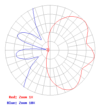
| Antenna Data for Antenna Id: 69523 WRCB DX File: BXLCDT-20070912AAO DIELECTRIC - THA-C2-1H/2H-1R Service: DX Standard Pattern: Y |  | |||||||||||||||||||||||||||||||||
| Azimuth | Ratio | Azimuth | Ratio | Azimuth | Ratio | Azimuth | Ratio | |||||||||||||||||||||||||||
| 0 | 0.411 | 10 | 0.588 | 20 | 0.732 | 30 | 0.858 | |||||||||||||||||||||||||||
| 40 | 0.948 | 50 | 1.000 | 60 | 0.966 | 70 | 0.877 | |||||||||||||||||||||||||||
| 80 | 0.830 | 90 | 0.936 | 100 | 0.993 | 110 | 0.907 | |||||||||||||||||||||||||||
| 120 | 0.831 | 130 | 0.891 | 140 | 0.966 | 150 | 0.995 | |||||||||||||||||||||||||||
| 160 | 0.924 | 170 | 0.791 | 180 | 0.619 | 190 | 0.407 | |||||||||||||||||||||||||||
| 200 | 0.236 | 210 | 0.134 | 220 | 0.082 | 230 | 0.053 | |||||||||||||||||||||||||||
| 240 | 0.030 | 250 | 0.058 | 260 | 0.076 | 270 | 0.064 | |||||||||||||||||||||||||||
| 280 | 0.009 | 290 | 0.072 | 300 | 0.076 | 310 | 0.056 | |||||||||||||||||||||||||||
| 320 | 0.030 | 330 | 0.061 | 340 | 0.120 | 350 | 0.230 | |||||||||||||||||||||||||||
Structure Registration Number 1044277 Structure Type: TOWER Registered To: SARKES TARZIAN INC DBA = WRCB TV Structure Address: Fairmount Rd Walden, TN County Name: Hamilton County ASR Issued: 03/20/2006 Date Built: 01/06/2006 Site Elevation: 628.5 m (2062 ft.) Structure Height: 61 m (200 ft.) Height Overall: 61 m (200 ft.) Overall Height AMSL: 689.5 m (2262 ft.) FAA Determination: 09/09/2004 FAA Study #: 2004-ASO-5066-OE Paint & Light FAA Chapters: NONE PRIOR STUDY 1966-MEM-149-OE 35-09-40.3 N 85-18-51.9 W (NAD 83) 35-09-40.0 N 85-18-52.0 W (Converted to NAD 27) |
900 Whitehall Road Chattanooga, TN 37405 Phone: 423-498-3704 Corporation | Date: 09/12/2007 Application Certifier Sarkes Tarzian, Inc. 205 North College Avenue PO Box 62 Bloomington, IN 47402 Applicant Bernard R. Segal, P. E. 3612 Sandy Court Kensington, MD 20895-1421 Consulting Engineer Brian M. Madden, Esq. Leventhal Senter & Lerman PLLC | ||||||||||||||||||||||||||||||||
|
| |||||||||||||||||||||||||||||||||