FCCInfo.com
A Service of Cavell, Mertz & Associates, Inc.
(855) FCC-INFO
|
|
|
|
|
||||||||||||||||
|
|
Status: LIC Application Accepted: 06/02/2014 License Expires: 04/01/2022 File Number: BLDTL-20140602AXJ Prefix Type: This is BLDTL FCC Website Links: LMS Facility Details This Application Other K25LM-D Applications Including Superseded Applications Service Contour - Open Street Map or USGS Map (51 dBu) Service Contour - KML / Google Earth (51 dBu) Rabbit Ears Info Search for K25LM-D Site Location: 47-27-51.8 N 111-21-21.1 W (NAD 83) Site Location: 47-27-52.0 N 111-21-18.2 W (Converted to NAD 27) ERP: 0.3 kW R/C AGL: 5 m (16 ft.) R/C AMSL: 1131 m (3711 ft.) Emission Mask: Stringent Site Elevation: 1126 m. (3694 ft.) Height Overall*: 27.4 m (90 ft.) (* As Filed In This Application, may differ from ASR Data, Below.) Directional Antenna - Antenna Make/Model: Scala CL-1469 Antenna ID: 20778 | ||||||||||||||||||
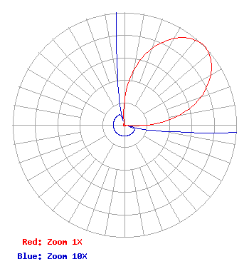
| Antenna Data for Antenna Id: 20778 K25LM-D LD File: BLDTL-20140602AXJ Scala - CL-1469 Service: LD Standard Pattern: Y Pattern and Field Values Include a 45° Clockwise Rotation |  | ||||||||||||||||||
| Azimuth | Ratio | Azimuth | Ratio | Azimuth | Ratio | Azimuth | Ratio | ||||||||||||
| 5 | 0.361 | 15 | 0.622 | 25 | 0.812 | 35 | 0.947 | ||||||||||||
| 45 | 1.000 | 55 | 0.947 | 65 | 0.812 | 75 | 0.622 | ||||||||||||
| 85 | 0.361 | 95 | 0.086 | 105 | 0.010 | 115 | 0.010 | ||||||||||||
| 125 | 0.010 | 135 | 0.010 | 145 | 0.010 | 155 | 0.010 | ||||||||||||
| 165 | 0.010 | 175 | 0.010 | 185 | 0.010 | 195 | 0.010 | ||||||||||||
| 205 | 0.010 | 215 | 0.010 | 225 | 0.010 | 235 | 0.010 | ||||||||||||
| 245 | 0.010 | 255 | 0.010 | 265 | 0.010 | 275 | 0.010 | ||||||||||||
| 285 | 0.010 | 295 | 0.010 | 305 | 0.010 | 315 | 0.010 | ||||||||||||
| 325 | 0.010 | 335 | 0.010 | 345 | 0.010 | 355 | 0.086 | ||||||||||||
Structure Registration Number 1265983 Structure Type: TOWER Registered To: Hi-Line Radio Fellowship, Inc. Structure Address: 3001 47th Avenue Sw Great Falls, MT County Name: Cascade County ASR Issued: 10/22/2011 Date Built: 12/01/2011 Site Elevation: 1125.9 m (3694 ft.) Structure Height: 27.4 m (90 ft.) Height Overall: 27.4 m (90 ft.) Overall Height AMSL: 1153.3 m (3784 ft.) FAA Determination: 10/13/2011 FAA Study #: 2011-ANM-2045-OE Paint & Light FAA Chapters: NONE PRIOR STUDY 2008-ANM-1232-OE 47-27-51.8 N 111-21-21.1 W (NAD 83) 47-27-52.0 N 111-21-18.2 W (Converted to NAD 27) |
Hurst, TX 76054 Phone: 214-770-7770 Corporation | Date: 06/02/2014 Application Certifier EICB-TV East, LLC PO Box 54025 Hurst, TX 76054-4025 Applicant B. W. St. Clair 2355 Ranch Drive Westminster, CO 80234 Engineering Consultant Dr. Randy Weiss EICB-TV East, LLC | |||||||||||||||||