FCCInfo.com
A Service of Cavell, Mertz & Associates, Inc.
(855) FCC-INFO
|
|
|
|  |
|
||||||||||||||||||||||||||||||||||||
|
|
WRTI Channel: 211B 90.1 MHz Philadelphia, Pennsylvania Service: FM - A full-service FM station or application. Facility ID: 65190 FRN: 0003270212 Fac. Service: FM Analog & Digital Status: LIC Application Accepted: 09/27/2010 Application Granted: 09/30/2010 File Number: BLED-20100927AHC License Expires: 08/01/2030 Prefix Type: This is a license for a noncommercial educational FM station Application Type: License To Cover FCC Website Links: LMS Facility Details This Application Other WRTI Applications Including Superseded Applications Service Contour - Open Street Map or USGS Map (60 dBu) Service Contour - KML / Google Earth (60 dBu) Public Inspection Files Facility Type: NON-COMMERCIAL EDUC. FM Class: B, A Zone I or I-A station; with 25kW-50kW ERP and a class contour distance 39km-52km Site Location: 40-02-30.0 N 75-14-10.1 W (NAD 83) Site Location: 40-02-29.6 N 75-14-11.5 W (Converted to NAD 27) Effective Radiated Power: 7.7 kW Transmitter Output Power: 7.4 kW Antenna Center HAAT: 371 m (1217 ft.) Antenna Center AMSL: 435 m (1427 ft.) Antenna Center HAG: 346 m (1135 ft.) Calculated Site Elevation: 89 m. (292 ft.) Height Overall*: 383 m (1257 ft.) (* As Filed In This Application, may differ from ASR Data, Below.) Directional Antenna Antenna Make/Model: Electronics Research Inc. 1084-2CP-DA, two sections Antenna ID: 84290 Polarization:
| |||||||||||||||||||||||||||||||||||||||
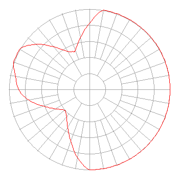
| Antenna Data for Antenna Id: 84290 WRTI FM File: BLED-20100927AHC Electronics Research Inc. - 1084-2CP-DA, two sections Service: FM |  | |||||||||||||||||||||||||||||||||||||||
| Azimuth | Ratio | Azimuth | Ratio | Azimuth | Ratio | Azimuth | Ratio | |||||||||||||||||||||||||||||||||
| 0 | 0.821 | 10 | 1.000 | 20 | 1.000 | 30 | 1.000 | |||||||||||||||||||||||||||||||||
| 40 | 1.000 | 50 | 1.000 | 60 | 1.000 | 70 | 1.000 | |||||||||||||||||||||||||||||||||
| 80 | 1.000 | 90 | 1.000 | 100 | 1.000 | 110 | 1.000 | |||||||||||||||||||||||||||||||||
| 120 | 1.000 | 130 | 1.000 | 140 | 1.000 | 150 | 1.000 | |||||||||||||||||||||||||||||||||
| 160 | 1.000 | 170 | 1.000 | 180 | 1.000 | 190 | 0.860 | |||||||||||||||||||||||||||||||||
| 200 | 0.683 | 210 | 0.543 | 220 | 0.444 | 230 | 0.405 | |||||||||||||||||||||||||||||||||
| 240 | 0.484 | 250 | 0.609 | 260 | 0.767 | 270 | 0.880 | |||||||||||||||||||||||||||||||||
| 280 | 0.933 | 290 | 1.000 | 300 | 1.000 | 310 | 0.870 | |||||||||||||||||||||||||||||||||
| 320 | 0.691 | 330 | 0.549 | 335 | 0.518 | 340 | 0.518 | |||||||||||||||||||||||||||||||||
| 350 | 0.652 | |||||||||||||||||||||||||||||||||||||||
Structure Registration Number 1231524 [ASR Heights Differ from WRTI Application] Structure Type: GTOWER Registered To: Global Tower, LLC. through American Towers, LLC Structure Address: 400-405 Domino Lane (016473 / Domino Lane Pa) Philadelphia, PA County Name: Philadelphia County ASR Issued: 04/19/2017 Date Built: 11/02/2011 Site Elevation: 89.3 m (293 ft.) Structure Height: 342.6 m (1124 ft.) Height Overall: 382.5 m (1255 ft.) Overall Height AMSL: 471.8 m (1548 ft.) FAA Determination: 04/18/2017 FAA Study #: 2017-AEA-3624-OE FAA Circular #: 70/7460-1K Paint & Light FAA Chapters: 3, 4, 5, 12 OM&L to remain the same as prior study = PAINT/RED LIGHTS 40-02-30.1 N 75-14-10.1 W (NAD 83) 40-02-29.7 N 75-14-11.5 W (Converted to NAD 27) |
1509 Cecil B. Moore Avenue WRTI/Third Floor Philadelphia, PA 19121 Phone: 215-204-8405 Not-for-Profit | Date: 09/27/2010 Application Certifier Temple University of the Commonwealth System of Higher Ed 1509 Cecil B. Moore Avenue WRTI/Third Floor Philadelphia, PA 19121-3410 Applicant Jeffrey J. Depolo Broadcast Sciences L L C 1465 Horseshoe Trail Malvern, PA 19355-9552 Consultant Peter Tannenwald Fletcher, Heald & Hildredth, P.L.C. | ||||||||||||||||||||||||||||||||||||||
|
| |||||||||||||||||||||||||||||||||||||||