
FCCInfo.com
A Service of Cavell, Mertz & Associates, Inc.
(855) FCC-INFO
|
|
W284CY from 12/03/2013 |
|
|
||||||||||||||||
|
|
W284CY Channel: 284D 104.7 MHz Hammond, Indiana Service: FX - A translator or application for a translator. Facility ID: 151550 Fac. Service: FX Programming Delivery Method: Unspecified Status: LIC Application Accepted: 06/01/2016 Application Granted: 06/23/2016 File Number: BLFT-20160601AAH Prefix Type: This is a license for a translator Application Type: License To Cover FCC Website Links: LMS Facility Details This Application CDBS Application Other W284CY Applications Other W284CY Applications in CDBS Including Superseded Applications Mailing Address Correspondence for W284CY Correspondence related to application BLFT-20160601AAH Service Contour - Open Street Map or USGS Map (60 dBu) Service Contour - KML / Google Earth (60 dBu) Class: D, A Noncommercial educational operating with no more than 10W Site Location: 41-35-49.1 N 87-28-45.1 W (NAD 83) Site Location: 41-35-49.0 N 87-28-45.0 W (Converted to NAD 27) Effective Radiated Power: 0.25 kW Transmitter Output Power: 0.2 kW Antenna Center HAAT: 0 m Antenna Center AMSL: 301 m (988 ft.) Antenna Center HAG: 119 m (390 ft.) Site Elevation: 182 m. (597 ft.) Height Overall*: 124 m (407 ft.) (* As Filed In This Application, may differ from ASR Data, Below.) Directional Antenna Antenna Make/Model: None Antenna ID: 123347 Polarization:
| ||||||||||||||||||
| Antenna Data for Antenna Id: 123347 W284CY FX File: BLFT-20160601AAH None - Service: FX | 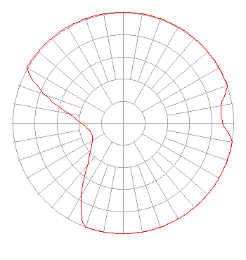 | ||||||||||||||||||
| Azimuth | Ratio | Azimuth | Ratio | Azimuth | Ratio | Azimuth | Ratio | ||||||||||||
| 0 | 1.000 | 10 | 1.000 | 20 | 1.000 | 30 | 1.000 | ||||||||||||
| 40 | 1.000 | 50 | 1.000 | 60 | 1.000 | 70 | 1.000 | ||||||||||||
| 80 | 0.900 | 90 | 0.900 | 100 | 1.000 | 110 | 1.000 | ||||||||||||
| 120 | 1.000 | 130 | 1.000 | 140 | 1.000 | 150 | 1.000 | ||||||||||||
| 160 | 1.000 | 170 | 1.000 | 180 | 1.000 | 190 | 1.000 | ||||||||||||
| 200 | 1.000 | 210 | 0.750 | 220 | 0.500 | 230 | 0.380 | ||||||||||||
| 240 | 0.320 | 250 | 0.300 | 260 | 0.320 | 270 | 0.380 | ||||||||||||
| 280 | 0.500 | 290 | 0.750 | 300 | 1.000 | 310 | 1.000 | ||||||||||||
| 320 | 1.000 | 330 | 1.000 | 340 | 1.000 | 350 | 1.000 | ||||||||||||
Structure Registration Number 1031697 Structure Type: LTOWER Registered To: Vazquez Development, LLC Structure Address: 6405 Olcott Hammond, IN County Name: Lake County ASR Issued: 12/29/2021 Date Built: 01/01/1945 Site Elevation: 182.3 m (598 ft.) Structure Height: 123.7 m (406 ft.) Height Overall: 123.7 m (406 ft.) Overall Height AMSL: 306 m (1004 ft.) FAA Determination: 04/08/2021 FAA Study #: 2021-AGL-7615-OE FAA Circular #: 70/7460-1M Paint & Light FAA Chapters: 4, 8, 15 41-35-49.0 N 87-28-45.0 W (NAD 83) 41-35-48.9 N 87-28-44.9 W (Converted to NAD 27) |
6405 Olcott Avenue Hammond, IN 46320 Phone: 219-844-1230 | Date: 06/01/2016 Application Certifier VAZQUEZ DEVELOPMENT, LLC 6405 Olcott Avenue Hammond, IN 46320 Applicant GARY S. SMITHWICK, ESQ. Smithwick & Belendiuk, P.c. 5028 Wisconsin Avenue. Nw Washington, DC 20016 JUSTIN W. ASHER Munn-reese, Inc. P.o. Box 220; 385 Airport Drive Coldwater, MI 49036-0220 CONSULTING ENGINEER | |||||||||||||||||