|
KSTJ Channel: 217C1 91.3 MHz
Hartford, South Dakota
Service: FM - A full-service FM station or application.
Facility ID: 175622
FRN: 0011873114
Fac. Service: FM
Status: LIC
Application Accepted: 10/22/2013
Application Granted: 12/03/2013
File Number: BLED-20131022AMW
License Expires: 04/01/2029
Prefix Type: This is a license for a noncommercial educational FM station
Application Type: Amendment
FCC Website Links:
LMS Facility Details
This Application
Other KSTJ Applications
Including Superseded Applications
Service Contour - Open Street Map or USGS Map (60 dBu)
Service Contour - KML / Google Earth (60 dBu)
Public Inspection Files
Facility Type: NON-COMMERCIAL EDUC. FM
Class: C1, A Zone II station; with 50kW-100kW ERP and a class contour distance 52km-72km
Site Location: 43-29-21.9 N 97-26-34.2 W (NAD 83)
Site Location: 43-29-22.0 N 97-26-33.0 W (Converted to NAD 27)
Effective Radiated Power: 41 kW
Transmitter Output Power: 11.2 kW
Antenna Center HAAT: 220.8 m (724 ft.)
Antenna Center AMSL: 656 m (2152 ft.)
Antenna Center HAG: 219.5 m (720 ft.)
Calculated Site Elevation: 436.5 m. (1432 ft.)
Height Overall*: 307.2 m (1008 ft.)
(* As Filed In This Application, may differ from ASR Data, Below.)
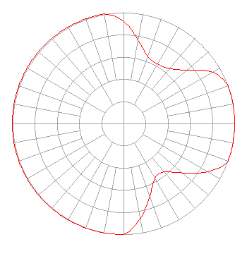
Directional Antenna
Antenna Make/Model: Propagation System Inc PSIFMR-8C-DA, eight sections
Antenna ID: 116414
Polarization:
|
Structure Information
Structure Registration Number 1047119
Structure Type: TOWER
Registered To:
VB-S1 Assets, LLC
Structure Address:
0.12 Miles Nnw Of 438 Avenue & 269 Street
Dolton, SD
County Name: Hutchinson County
ASR Issued: 09/29/2025
Date Built: 10/01/1993
Site Elevation: 436.5 m (1432 ft.)
Structure Height: 269 m (883 ft.)
Height Overall: 307.2 m (1008 ft.)
Overall Height AMSL: 743.7 m (2440 ft.)
FAA Determination: 04/10/1998
FAA Study #: 98-AGL-0530-OE
FAA Circular #: 70/7460-1G
Paint & Light FAA Chapters: 3, 4, 5, 9
43-29-22.0 N 97-26-34.0 W (NAD 83)
43-29-22.1 N 97-26-32.8 W
(Converted to NAD 27)
|
KSTJ(FM) Licensee Information
Real Presence Radio
503 7th Street N
Suite 101
Fargo, ND 58102-4403
Phone: 701-795-0122
| 20131022AMW Applicant Information
Matthew Althoff
Date: 10/22/2013
Application Certifier
Catholic Chancery Office
523 North Duluth Avenue
Sioux Falls, SD 57104-2714
Applicant
Jeremy D. Ruck, PE
Jeremy Ruck & Associates, Inc.
P.O. Box 415
Canton, IL 61520
Consulting Engineer
J. Dominic Monahan
Luvaas Cobb
|