FCCInfo.com
A Service of Cavell, Mertz & Associates, Inc.
(855) FCC-INFO
|
|
WHP-TV from 06/06/1981 WJAC from ??? |
Virtual Channel 6 |
|
||||||||||||||||||||||||||||
|
|
Status: LIC Application Accepted: 02/15/2012 License Expires: 08/01/2023 File Number: BLCDT-20120215ABZ Prefix Type: This is a License for a commercial digital TV station FCC Website Links: LMS Facility Details This Application Other WJAC-TV Applications Including Superseded Applications Service Contour - Open Street Map or USGS Map (51 dBu) Service Contour - KML / Google Earth (51 dBu) Rabbit Ears Info Search for WJAC-TV Site Location: 41-02-43.0 N 78-42-10.0 W (NAD 83) Site Location: 41-02-42.8 N 78-42-10.9 W (Converted to NAD 27) ERP: 0.7 kW Electrical Beam Tilt: 1 degree R/C AGL: 74 m (243 ft.) R/C AMSL: 699.8 m (2296 ft.) Emission Mask: Stringent Site Elevation: 625.8 m. (2053 ft.) Height Overall*: 98.1 m (322 ft.) (* As Filed In This Application, may differ from ASR Data, Below.) Directional Antenna - Antenna Make/Model: DIELECTRIC TUL-C3-01/03M-T Antenna ID: 106678 | ||||||||||||||||||||||||||||||
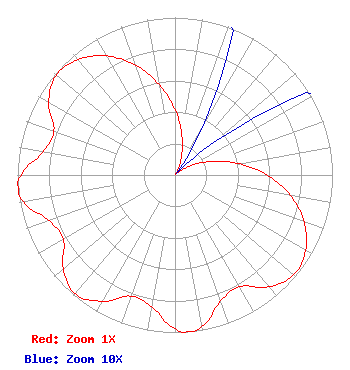
| Antenna Data for Antenna Id: 106678 WJAC-TV LD File: BLCDT-20120215ABZ DIELECTRIC - TUL-C3-01/03M-T Service: LD Standard Pattern: Y |  | ||||||||||||||||||||||||||||||
| Azimuth | Ratio | Azimuth | Ratio | Azimuth | Ratio | Azimuth | Ratio | ||||||||||||||||||||||||
| 0 | 0.415 | 10 | 0.253 | 20 | 0.120 | 30 | 0.032 | ||||||||||||||||||||||||
| 40 | 0.001 | 50 | 0.032 | 60 | 0.120 | 70 | 0.253 | ||||||||||||||||||||||||
| 80 | 0.415 | 90 | 0.585 | 100 | 0.744 | 110 | 0.873 | ||||||||||||||||||||||||
| 120 | 0.957 | 130 | 0.986 | 140 | 0.926 | 150 | 0.818 | ||||||||||||||||||||||||
| 160 | 0.850 | 170 | 0.977 | 175 | 1.000 | 180 | 0.977 | ||||||||||||||||||||||||
| 190 | 0.850 | 200 | 0.818 | 210 | 0.926 | 220 | 0.986 | ||||||||||||||||||||||||
| 230 | 0.926 | 240 | 0.818 | 250 | 0.850 | 260 | 0.977 | ||||||||||||||||||||||||
| 265 | 1.000 | 270 | 0.977 | 280 | 0.850 | 290 | 0.818 | ||||||||||||||||||||||||
| 300 | 0.926 | 310 | 0.986 | 320 | 0.957 | 330 | 0.873 | ||||||||||||||||||||||||
| 340 | 0.744 | 350 | 0.585 | ||||||||||||||||||||||||||||
Structure Registration Number 1025586 [ASR Heights Differ from WJAC-TV Application] Structure Type: TOWER Registered To: GTC Uno, LLC Structure Address: Along Rt 219 1 Mi E Luthersburg, PA County Name: Clearfield County ASR Issued: 07/16/2024 Date Built: 01/01/1992 Site Elevation: 622 m (2041 ft.) Structure Height: 90.9 m (298 ft.) Height Overall: 98 m (322 ft.) Overall Height AMSL: 720 m (2362 ft.) FAA Determination: 08/18/1992 FAA Study #: 92-AEA-1330-OE Paint & Light FAA Chapters: A1, H MEDIUM INTENSITY WHITE LIGHTS 41-02-43.0 N 78-42-10.0 W (NAD 83) 41-02-42.8 N 78-42-10.9 W (Converted to NAD 27) |
1200 Seventeenth Street, NW Washington, DC 20036 Phone: 202-663-8195 Limited Liability Company | Date: 02/15/2012 Application Certifier WPXI, Inc. 49 Old Hickory Lane Johnstown, PA 15905 Applicant Rob Abele 49 Old Hickory Lane Johnstown, PA 15905 Chief Engineer Robert J. Folliard, III, Esq. Dow Lohnes PLLC | |||||||||||||||||||||||||||||
|
| ||||||||||||||||||||||||||||||