FCCInfo.com
A Service of Cavell, Mertz & Associates, Inc.
(855) FCC-INFO
|
|
KBFX-LP from 06/01/1998 KMPH-LP from 10/30/1995 K58DJ from 08/23/1989 890310D8 from ??? |
Virtual Channel 58 |
|
||||||||||||||||||
|
|
Status: LIC Application Accepted: 10/18/2010 License Expires: 12/01/2030 File Number: BLTTA-20101018ACF Prefix Type: This is a license for a Class A UHF translator FCC Website Links: LMS Facility Details This Application Other KBFX-CD Applications Including Superseded Applications Service Contour - Open Street Map or USGS Map (51 dBu) Service Contour - KML / Google Earth (51 dBu) Public Inspection Files Rabbit Ears Info Search for KBFX-CD Site Location: 35-27-10.8 N 118-35-28.3 W (NAD 83) Site Location: 35-27-11.0 N 118-35-25.0 W (Converted to NAD 27) ERP: 15 kW R/C AGL: 59 m (194 ft.) R/C AMSL: 2358.7 m (7739 ft.) Site Elevation: 2299.7 m. (7545 ft.) Height Overall*: 70.1 m (230 ft.) (* As Filed In This Application, may differ from ASR Data, Below.) Directional Antenna - Antenna Make/Model: RCA Corp. TZP-504 Antenna ID: 92201 | ||||||||||||||||||||
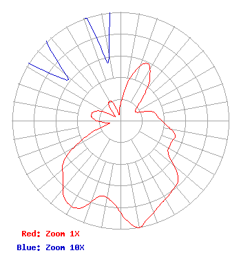
| Antenna Data for Antenna Id: 92201 KBFX-CD DC File: BLTTA-20101018ACF RCA Corp. - TZP-504 Service: DC Standard Pattern: Y Pattern and Field Values Include a 85° Clockwise Rotation |  | ||||||||||||||||||||
| Azimuth | Ratio | Azimuth | Ratio | Azimuth | Ratio | Azimuth | Ratio | ||||||||||||||
| 5 | 0.210 | 15 | 0.450 | 25 | 0.580 | 35 | 0.470 | ||||||||||||||
| 45 | 0.280 | 55 | 0.170 | 65 | 0.180 | 75 | 0.310 | ||||||||||||||
| 85 | 0.350 | 95 | 0.420 | 105 | 0.520 | 115 | 0.510 | ||||||||||||||
| 125 | 0.540 | 135 | 0.750 | 145 | 0.810 | 155 | 0.860 | ||||||||||||||
| 165 | 0.940 | 170 | 1.000 | 175 | 0.940 | 185 | 0.760 | ||||||||||||||
| 195 | 0.720 | 205 | 0.890 | 215 | 0.890 | 225 | 0.750 | ||||||||||||||
| 235 | 0.630 | 245 | 0.350 | 255 | 0.110 | 265 | 0.170 | ||||||||||||||
| 275 | 0.260 | 285 | 0.270 | 295 | 0.210 | 305 | 0.070 | ||||||||||||||
| 315 | 0.090 | 325 | 0.190 | 330 | 0.200 | 335 | 0.190 | ||||||||||||||
| 345 | 0.070 | 350 | 0.060 | 355 | 0.110 | ||||||||||||||||
Structure Registration Number 1015228 Structure Type: TOWER Registered To: Sinclair Bakersfield Licensee, LLC Structure Address: Atop Breckenridge Mountain Bakersfield, CA County Name: Kern County ASR Issued: 01/10/2017 Date Built: 04/23/2007 Site Elevation: 2299.7 m (7545 ft.) Structure Height: 50.3 m (165 ft.) Height Overall: 70.1 m (230 ft.) Overall Height AMSL: 2369.8 m (7775 ft.) FAA Determination: 04/23/1969 FAA Study #: 69-LAX-211-OE Paint & Light FAA Chapters: 1, 3, 11, 21 RED LIGHTS/PAINT 35-27-10.8 N 118-35-28.3 W (NAD 83) 35-27-11.0 N 118-35-25.0 W (Converted to NAD 27) |
Pillsbury Winthrop Shaw Pittman LLP 1200 Seventeenth Street, NW Washington, DC 20036 Phone: 202-663-8195 Limited Liability Company | Date: 10/18/2010 Application Certifier Fisher Broadcasting - California TV, L.L.C. 140 4th Avenue N. Suite 500 Seattle, WA 98109 Applicant Lee Wood 140 Fourth Avenue North Seattle, WA 98109 Regional Director of Engineering Wade H. Hargrove Brooks, Pierce, Et. Al. | |||||||||||||||||||
| |||||||||||||||||||||