FCCInfo.com
A Service of Cavell, Mertz & Associates, Inc.
(855) FCC-INFO
|
|
|
Virtual Channel 4 |  |
|
|||||||||||||||||||||||||||||||||||||||||||||
|
|
Status: LIC Application Accepted: 11/18/2013 License Expires: 10/01/2030 File Number: BLEDT-20131118BCR Prefix Type: This is a license for a noncommercial educational digital TV station FCC Website Links: LMS Facility Details This Application Other KAID Applications Including Superseded Applications Service Contour - Open Street Map or USGS Map (51 dBu) Service Contour - KML / Google Earth (51 dBu) Public Inspection Files Rabbit Ears Info Search for KAID Site Location: 44-26-24.6 N 116-07-32.5 W (NAD 83) Site Location: 44-26-25.0 N 116-07-29.0 W (Converted to NAD 27) ERP: 0.085 kW R/C AGL: 17 m (56 ft.) R/C AMSL: 2553 m (8376 ft.) Emission Mask: Simple Site Elevation: 2536 m. (8320 ft.) Height Overall*: 20.1 m (66 ft.) (* As Filed In This Application, may differ from ASR Data, Below.) Directional Antenna - Antenna Make/Model: Scala 4DR-4-2HW Antenna ID: 20741 | ||||||||||||||||||||||||||||||||||||||||||||||||
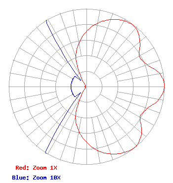
| Antenna Data for Antenna Id: 20741 KAID LD File: BLEDT-20131118BCR Scala - 4DR-4-2HW Service: LD Standard Pattern: Y Pattern and Field Values Include a 90° Clockwise Rotation |  | ||||||||||||||||||||||||||||||||||||||||||||||||
| Azimuth | Ratio | Azimuth | Ratio | Azimuth | Ratio | Azimuth | Ratio | ||||||||||||||||||||||||||||||||||||||||||
| 0 | 0.710 | 10 | 0.825 | 20 | 0.915 | 30 | 0.975 | ||||||||||||||||||||||||||||||||||||||||||
| 40 | 0.983 | 50 | 0.895 | 60 | 0.784 | 70 | 0.827 | ||||||||||||||||||||||||||||||||||||||||||
| 80 | 0.955 | 90 | 1.000 | 100 | 0.945 | 110 | 0.830 | ||||||||||||||||||||||||||||||||||||||||||
| 120 | 0.795 | 130 | 0.925 | 140 | 0.995 | 150 | 0.975 | ||||||||||||||||||||||||||||||||||||||||||
| 160 | 0.920 | 170 | 0.835 | 180 | 0.715 | 190 | 0.580 | ||||||||||||||||||||||||||||||||||||||||||
| 200 | 0.410 | 210 | 0.135 | 220 | 0.020 | 230 | 0.020 | ||||||||||||||||||||||||||||||||||||||||||
| 240 | 0.020 | 250 | 0.020 | 260 | 0.020 | 270 | 0.020 | ||||||||||||||||||||||||||||||||||||||||||
| 280 | 0.020 | 290 | 0.020 | 300 | 0.020 | 310 | 0.020 | ||||||||||||||||||||||||||||||||||||||||||
| 320 | 0.020 | 330 | 0.130 | 340 | 0.395 | 350 | 0.560 | ||||||||||||||||||||||||||||||||||||||||||
Structure Registration Number 1047645 [ASR Heights Differ from KAID Application] Structure Type: MTOWER Registered To: AT&T Mobility Spectrum LLC Structure Address: Sw 1/4 Se 1/4 Section 20, Township 13 N, Range 3 E Cascade, ID County Name: Valley County ASR Issued: 09/30/2025 Date Built: 07/18/1997 Site Elevation: 2543.3 m (8344 ft.) Structure Height: 14.3 m (47 ft.) Height Overall: 16.5 m (54 ft.) Overall Height AMSL: 2559.8 m (8398 ft.) FAA Determination: 04/20/2018 FAA Study #: 2018-ANM-1385-OE Paint & Light FAA Chapters: NONE 44-26-24.4 N 116-07-32.7 W (NAD 83) 44-26-24.8 N 116-07-29.2 W (Converted to NAD 27) |
1455 North Orchard Street Boise, ID 83706 Phone: 208-373-7220 Fax: 208-373-7245 Government Entity | Date: 11/18/2013 Application Certifier State Board of Education, State of Idaho 1455 N. Orchard Street ATTN: Richard Van Genderen Boise, ID 83706-2239 Applicant Richard Vangenderen Idaho Public Television 1455 N. Orchard Street Boise, ID 83706-2239 Technology Director Anne Goodwin Crump Fletcher, Heald and Hildreth, P.L.C. | |||||||||||||||||||||||||||||||||||||||||||||||
|
| ||||||||||||||||||||||||||||||||||||||||||||||||