FCCInfo.com
A Service of Cavell, Mertz & Associates, Inc.
(855) FCC-INFO
|
|
WABT from 05/24/2012 WTSX from 07/03/1984 WDLC-FM from 05/11/1979 WDLCFM from ??? |
|  |
|
|||||||||||||||
|
|
WVPO Channel: 244A 96.7 MHz Lehman Township, Pennsylvania Service: FM - A full-service FM station or application. Facility ID: 53036 FRN: 0021206529 Fac. Service: FM Status: LIC 73.215 Station Application Accepted: 06/30/2011 Application Granted: 07/20/2011 File Number: BLH-20110630AAC License Expires: 08/01/2030 Prefix Type: This is a license for a commercial FM station Application Type: License To Cover FCC Website Links: LMS Facility Details This Application Other WVPO Applications Including Superseded Applications Service Contour - Open Street Map or USGS Map (60 dBu) Service Contour - KML / Google Earth (60 dBu) Public Inspection Files Facility Type: FM STATION Class: A, A Zone I; I-A; or II station; with 0.1kW-6kW ERP and a class contour distance <=28km Site Location: 41-07-53.3 N 74-58-43.6 W (NAD 83) Site Location: 41-07-53.0 N 74-58-45.0 W (Converted to NAD 27) Effective Radiated Power: 5 kW Transmitter Output Power: 2.6 kW Antenna Center HAAT: 70 m (230 ft.) Antenna Center AMSL: 344 m (1129 ft.) Antenna Center HAG: 79 m (259 ft.) Calculated Site Elevation: 265 m. (869 ft.) Height Overall*: 108 m (354 ft.) (* As Filed In This Application, may differ from ASR Data, Below.) Directional Antenna Antenna Make/Model: Electronics Research Inc. LP-2E-DA Antenna ID: 90143 Polarization:
| ||||||||||||||||||
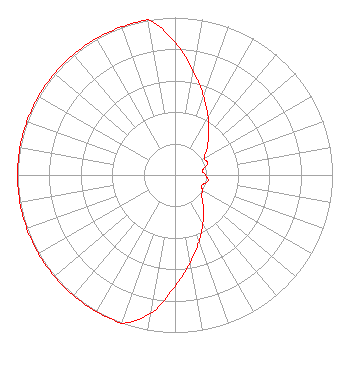
| Antenna Data for Antenna Id: 90143 WVPO FM File: BLH-20110630AAC Electronics Research Inc. - LP-2E-DA Service: FM |  | ||||||||||||||||||
| Azimuth | Ratio | Azimuth | Ratio | Azimuth | Ratio | Azimuth | Ratio | ||||||||||||
| 0 | 0.841 | 10 | 0.668 | 20 | 0.530 | 30 | 0.421 | ||||||||||||
| 40 | 0.334 | 50 | 0.266 | 60 | 0.213 | 70 | 0.220 | ||||||||||||
| 80 | 0.177 | 90 | 0.193 | 100 | 0.214 | 110 | 0.184 | ||||||||||||
| 120 | 0.199 | 130 | 0.223 | 140 | 0.281 | 150 | 0.354 | ||||||||||||
| 160 | 0.446 | 170 | 0.562 | 180 | 0.707 | 190 | 0.891 | ||||||||||||
| 200 | 1.000 | 210 | 1.000 | 220 | 1.000 | 230 | 1.000 | ||||||||||||
| 240 | 1.000 | 250 | 1.000 | 260 | 1.000 | 270 | 1.000 | ||||||||||||
| 280 | 1.000 | 290 | 1.000 | 300 | 1.000 | 310 | 1.000 | ||||||||||||
| 320 | 1.000 | 330 | 1.000 | 340 | 1.000 | 350 | 1.000 | ||||||||||||
Structure Registration Number 1027006 [ASR Heights Differ from WVPO Application] Structure Type: LTOWER Registered To: FELHC Structure Address: 3 Mi Ne Bushkill, PA County Name: Pike County ASR Issued: 07/24/2025 Date Built: 08/26/2009 Site Elevation: 266.3 m (874 ft.) Structure Height: 106.7 m (350 ft.) Height Overall: 110 m (361 ft.) Overall Height AMSL: 376.3 m (1235 ft.) FAA Determination: 07/02/2025 FAA Study #: 2025-AEA-5778-OE FAA Circular #: 70/7460-1K Paint & Light FAA Chapters: 4, 8, 12 OM&L to remain the same as prior study = A MED-DUAL SYSTEM 41-07-53.3 N 74-58-45.1 W (NAD 83) 41-07-53.0 N 74-58-46.5 W (Converted to NAD 27) |
115 West Main St Frankfort, KY 40601 Phone: 502-875-1130 Limited Liability Company | Date: 06/30/2011 Application Certifier PJ Radio, L.L.C. 54 Huntingtown Road Newton, CT 06470 Applicant Dominic L. Bordonaro 155 Short Beach Road #208 Stratford, CT 06615 Assisting Engineer Marissa G. Repp, Esq. Repp Law Firm | |||||||||||||||||