FCCInfo.com
A Service of Cavell, Mertz & Associates, Inc.
(855) FCC-INFO
|
|
|
Virtual Channel 51 |
|
||||||||||||||||||
|
|
Status: LIC Application Accepted: 08/24/2011 License Expires: 06/01/2029 File Number: BLCDT-20110824ABD Prefix Type: This is a License for a commercial digital TV station FCC Website Links: LMS Facility Details This Application Other WWJX Applications Including Superseded Applications Service Contour - Open Street Map or USGS Map (41 dBu) Service Contour - KML / Google Earth (41 dBu) Public Inspection Files Rabbit Ears Info Search for WWJX Site Location: 32-03-13.6 N 90-20-23.3 W (NAD 83) Site Location: 32-03-13.0 N 90-20-23.0 W (Converted to NAD 27) ERP: 20 kW Polarization: Horizontally polarized HAAT: 150 m (492 ft.) Electrical Beam Tilt: 0.5 degrees R/C AGL: 128 m (420 ft.) R/C AMSL: 247 m (810 ft.) Site Elevation: 119 m. (390 ft.) Height Overall*: 152 m (499 ft.) (* As Filed In This Application, may differ from ASR Data, Below.) Directional Antenna - Antenna Make/Model: DIELECTRIC TUA-C2-3/6H-1SP Antenna ID: 105290 Polarization: Horizontally polarized | ||||||||||||||||||||
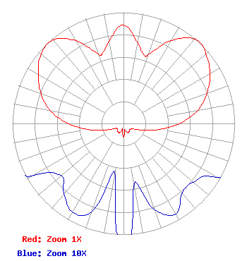
| Antenna Data for Antenna Id: 105290 WWJX DT File: BLCDT-20110824ABD DIELECTRIC - TUA-C2-3/6H-1SP Service: DT Standard Pattern: Y Pattern and Field Values Include a 80° Clockwise Rotation |  | ||||||||||||||||||||
| Azimuth | Ratio | Azimuth | Ratio | Azimuth | Ratio | Azimuth | Ratio | ||||||||||||||
| 0 | 0.885 | 10 | 0.735 | 17 | 0.643 | 20 | 0.665 | ||||||||||||||
| 30 | 0.864 | 40 | 0.994 | 45 | 1.000 | 50 | 0.969 | ||||||||||||||
| 60 | 0.899 | 70 | 0.799 | 80 | 0.679 | 90 | 0.504 | ||||||||||||||
| 100 | 0.317 | 110 | 0.176 | 120 | 0.097 | 130 | 0.082 | ||||||||||||||
| 140 | 0.082 | 150 | 0.094 | 160 | 0.083 | 170 | 0.055 | ||||||||||||||
| 180 | 0.122 | 190 | 0.045 | 200 | 0.085 | 210 | 0.092 | ||||||||||||||
| 220 | 0.083 | 230 | 0.073 | 240 | 0.093 | 250 | 0.172 | ||||||||||||||
| 260 | 0.317 | 270 | 0.500 | 280 | 0.671 | 290 | 0.790 | ||||||||||||||
| 300 | 0.886 | 310 | 0.969 | 320 | 0.982 | 330 | 0.860 | ||||||||||||||
| 340 | 0.673 | 343 | 0.657 | 350 | 0.754 | ||||||||||||||||
Structure Registration Number 1209376 Structure Type: Registered To: K-LOVE, Inc. Structure Address: Midway Road Terry, MS County Name: Hinds County ASR Issued: 12/06/2025 Date Built: 01/01/2002 Site Elevation: 118.9 m (390 ft.) Structure Height: 150.9 m (495 ft.) Height Overall: 152.1 m (499 ft.) Overall Height AMSL: 271 m (889 ft.) FAA Determination: 01/26/2000 FAA Study #: 99-ASO-4957-OE FAA Circular #: 70/7460-1J Paint & Light FAA Chapters: 3, 4, 5, 13 Removed expiration date from determination. Scenario 1./jjs/case#635066 32-03-13.6 N 90-20-23.3 W (NAD 83) 32-03-13.0 N 90-20-23.0 W (Converted to NAD 27) |
Marion, IL 62959 Phone: 618-997-4700 Not-for-Profit | Date: 08/24/2011 Application Certifier George S. Flinn, Jr. 188 South Bellevue Suite 222 Memphis, TN 38104 Applicant Charles A. Cooper Du Treil, Lundin & Rackley, Inc. 201 Fletcher Avenue Sarasto, FL 34237 Technical Consultant Stephen C. Simpson Attorney at Law 1250 Connecticut Avenue, N.W. Suite 200 Washington, DC 20036 | |||||||||||||||||||