|
W254CK Channel: 254D 98.7 MHz
Nashville, Tennessee
Service: FX - A translator or application for a translator.
Facility ID: 88416
FRN: 0006791354
Fac. Service: FX
Programming Delivery Method: Unspecified
Status: LIC
Application Accepted: 11/15/2016
Application Granted: 11/28/2016
File Number: BLFT-20161115ACE
License Expires: 08/01/2028
Prefix Type: This is a license for a translator
Application Type: License To Cover
FCC Website Links:
LMS Facility Details
This Application
Other W254CK Applications
Including Superseded Applications
Service Contour - Open Street Map or USGS Map (60 dBu)
Service Contour - KML / Google Earth (60 dBu)
Class: D, A Noncommercial educational operating with no more than 10W
Site Location: 36-16-05.2 N 86-47-45.0 W (NAD 83)
Site Location: 36-16-05.0 N 86-47-45.0 W (Converted to NAD 27)
Effective Radiated Power: 0.25 kW
Transmitter Output Power: 0.44 kW
Antenna Center AMSL: 531 m (1742 ft.)
Antenna Center HAG: 299 m (981 ft.)
Site Elevation: 232 m. (761 ft.)
Height Overall*: 393 m (1289 ft.)
(* As Filed In This Application, may differ from ASR Data, Below.)
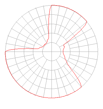
Directional Antenna
Antenna Make/Model: Scala CA2-FM(SLANT45) (1-BAY)
Antenna ID: 122944
Polarization:
| Primary Station |
| WFCN(AM) |
Ch. 0 | Nashville, Tennessee |
|
Structure Information
Structure Registration Number 1233975
Structure Type: GTOWER
Registered To:
American Towers LLC
Structure Address:
Nashville, Tn
Nashville, TN
County Name: Davidson County
ASR Issued: 05/16/2017
Date Built: 03/15/2002
Site Elevation: 231.7 m (760 ft.)
Structure Height: 352.9 m (1158 ft.)
Height Overall: 392.9 m (1289 ft.)
Overall Height AMSL: 624.6 m (2049 ft.)
FAA Study #: 02-ASO-2205-OE
FAA Circular #:
Paint & Light FAA Chapters: A1, B, E, H, 3, 8, 17, 21, 23
PRIOR STUDY 00-ASO-0114-OE
36-16-04.9 N 86-47-44.7 W (NAD 83)
36-16-04.7 N 86-47-44.7 W
(Converted to NAD 27)
|
W254CK(FX) Licensee Information
The Moody Bible Institute of Chicago
820 North Lasalle
Chicago, IL 60610
Phone: 312-329-4300
| 20161115ACE Applicant Information
Collin Lambert
Date: 11/15/2016
Application Certifier
The Moody Bible Institute of Chicago
820 North Lasalle Boulevard
Chicago, IL 60610-3284
Applicant
Jeffrey D Southmayd
Southmayd & Miller
4 Ocean Ridge Boulevard South
Palm Coast, FL 32137
Attorney
Jeffrey D. Southmayd
Southmayd & Miller
4 Ocean Ridge Boulevard South
Palm Coast, FL 32137
|