|
WRFE Channel: 207C1 89.3 MHz
Chesterfield, South Carolina
Service: FM - A full-service FM station or application.
Facility ID: 91536
FRN: 0002148864
Fac. Service: FM
Status: LIC
Application Accepted: 03/01/2018
Application Granted: 03/28/2018
File Number: BLED-20180301AAI
License Expires: 12/01/2027
Prefix Type: This is a license for a noncommercial educational FM station
Application Type: License To Cover
FCC Website Links:
LMS Facility Details
This Application
Other WRFE Applications
Including Superseded Applications
Service Contour - Open Street Map or USGS Map (60 dBu)
Service Contour - KML / Google Earth (60 dBu)
Public Inspection Files
Facility Type: NON-COMMERCIAL EDUC. FM
Class: C1, A Zone II station; with 50kW-100kW ERP and a class contour distance 52km-72km
Site Location: 34-54-10.0 N 80-09-13.6 W (NAD 83)
Site Location: 34-54-09.4 N 80-09-14.4 W (Converted to NAD 27)
Effective Radiated Power: 50 kW Horiz. ; 46 kW Vert.
Transmitter Output Power: 11 kW
Antenna Center HAAT: 188.8 m (619 ft.)
Antenna Center AMSL: 303.3 m (995 ft.)
Antenna Center HAG: 120.4 m (395 ft.)
Calculated Site Elevation: 182.9 m. (600 ft.)
Height Overall*: 127.4 m (418 ft.)
(* As Filed In This Application, may differ from ASR Data, Below.)
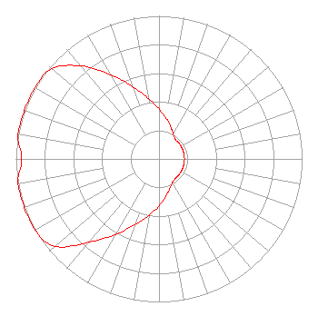
Directional Antenna
Antenna Make/Model: Jampro JFCB-2-1-2-1(6) DA
Antenna ID: 129311
Polarization:
| Associated Translators |
| W253BA(FX) |
Ch. 253 | Indian Trail, North Carolina |
|
Structure Information
Structure Registration Number 1303316
Structure Type: GTOWER
Registered To:
Positive Alternative Radio, Inc.
Structure Address:
35 Phillips Road
Wadesboro, NC
County Name: Anson County
ASR Issued: 09/06/2017
Date Built: 02/21/2018
Site Elevation: 182.9 m (600 ft.)
Structure Height: 126.5 m (415 ft.)
Height Overall: 127.4 m (418 ft.)
Overall Height AMSL: 310.3 m (1018 ft.)
FAA Determination: 01/31/2018
FAA Study #: 2017-ASO-26250-OE
FAA Circular #: 70/7460-1L
Paint & Light FAA Chapters: 4, 8, 12
PRIOR STUDY 2015-ASO-21078-OE
34-54-10.0 N 80-09-13.6 W (NAD 83)
34-54-09.4 N 80-09-14.4 W
(Converted to NAD 27)
|
WRFE(FM) Licensee Information
Positive Alternative Radio, Inc.
P.O. Box 889
Blacksburg, VA 24063
Phone: 540-552-4281
| 20180301AAI Applicant Information
Edward A. Baker
Date: 03/01/2018
Application Certifier
Positive Alternative Radio, Inc.
P.O. Box 889
Blacksburg, VA 24063-0889
Applicant
Roy P. Stype, III
P. O. Box 807
2324 North Cleveland-Massillon Road
Bath, OH 44210-0807
Consulting Engineer
Cary S. Tepper, Esq.
Tepper Law Firm, LLC
|