FCCInfo.com
A Service of Cavell, Mertz & Associates, Inc.
(855) FCC-INFO
|
|
KRIO-FM1 from 10/05/2004 |
|
|
||||||||||||||||
|
|
KSAH-FM1 Channel: 281D 104.1 MHz Pearsall, Texas Service: FB - A booster station or application for a booster. Facility ID: 161921 FRN: 0022491476 Fac. Service: FB Programming Delivery Method: Unspecified Status: LIC Application Accepted: 03/27/2006 Application Granted: 05/05/2006 File Number: BLFTB-20060327AJE License Expires: 08/01/2029 Prefix Type: This is a license for a booster Application Type: License To Cover FCC Website Links: LMS Facility Details This Application Other KSAH-FM1 Applications Including Superseded Applications Service Contour - Open Street Map or USGS Map (60 dBu) Service Contour - KML / Google Earth (60 dBu) Facility Type: FM STATION Class: D, A Noncommercial educational operating with no more than 10W Site Location: 28-54-58.3 N 98-39-40.2 W (NAD 83) Site Location: 28-54-57.4 N 98-39-39.1 W (Converted to NAD 27) Effective Radiated Power: 20 kW Transmitter Output Power: 8.97 kW Antenna Center HAAT: 0 m Antenna Center AMSL: 467 m (1532 ft.) Antenna Center HAG: 298 m (978 ft.) Site Elevation: 169 m. (554 ft.) Height Overall*: 303 m (994 ft.) (* As Filed In This Application, may differ from ASR Data, Below.) Directional Antenna Antenna Make/Model: None Antenna ID: 71115 Polarization:
| ||||||||||||||||||
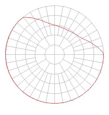
| Antenna Data for Antenna Id: 71115 KSAH-FM1 FB File: BLFTB-20060327AJE None - Service: FB Pattern and Field Values Include a 24° Clockwise Rotation |  | ||||||||||||||||||
| Azimuth | Ratio | Azimuth | Ratio | Azimuth | Ratio | Azimuth | Ratio | ||||||||||||
| 4 | 0.589 | 14 | 0.569 | 24 | 0.562 | 34 | 0.569 | ||||||||||||
| 44 | 0.589 | 54 | 0.622 | 64 | 0.692 | 74 | 0.802 | ||||||||||||
| 84 | 0.929 | 88 | 0.985 | 94 | 1.000 | 104 | 1.000 | ||||||||||||
| 114 | 1.000 | 124 | 1.000 | 134 | 1.000 | 144 | 1.000 | ||||||||||||
| 154 | 1.000 | 164 | 1.000 | 174 | 1.000 | 184 | 1.000 | ||||||||||||
| 194 | 1.000 | 204 | 1.000 | 214 | 1.000 | 224 | 1.000 | ||||||||||||
| 234 | 1.000 | 244 | 1.000 | 254 | 1.000 | 264 | 1.000 | ||||||||||||
| 274 | 1.000 | 284 | 1.000 | 294 | 1.000 | 304 | 1.000 | ||||||||||||
| 314 | 1.000 | 320 | 0.985 | 324 | 0.929 | 334 | 0.802 | ||||||||||||
| 344 | 0.692 | 354 | 0.622 | ||||||||||||||||
Structure Registration Number 1251093 Structure Type: GTOWER Registered To: VB-S1 Assets, LLC Structure Address: County Road 300-1/4 Mile From County Road 319 Jourdanton, TX County Name: Atascosa County ASR Issued: 09/29/2025 Date Built: 05/05/2006 Site Elevation: 168.8 m (554 ft.) Structure Height: 303.2 m (995 ft.) Height Overall: 303.2 m (995 ft.) Overall Height AMSL: 472 m (1549 ft.) FAA Determination: 12/13/2016 FAA Study #: 2016-ASW-11941-OE FAA Circular #: 70/7460-1L Paint & Light FAA Chapters: 4, 9, 12 PRIOR STUDY 2005-ASW-2913-OE 28-54-58.3 N 98-39-40.0 W (NAD 83) 28-54-57.4 N 98-39-38.9 W (Converted to NAD 27) |
1211 SW 5th Avenue Suite 750 Portland, OR 97204 Phone: 503-517-6200 Limited Liability Company | Date: 03/27/2006 Application Certifier BMP San Antonio License Company, L.P. 9426 Old KATY Road Building 10 Houston, TX 77055 Applicant Greg Shapiro 7301 Ranch Road 620 North Bldg. 155 Suite 279 Austin, TX 78726 Consulting Engineer Antoinette Cook Bush, Esq. Skadden, Arps, Slate, Meagher & Flom LLP 1440 New York Avenue, N.W. Washington, DC 20005 | |||||||||||||||||