FCCInfo.com
A Service of Cavell, Mertz & Associates, Inc.
(855) FCC-INFO
|
|
WGVC from ??? |
Virtual Channel 35 |  |
|
||||||||||||||||||||||||
|
|
Status: LIC Application Accepted: 08/27/2010 License Expires: 10/01/2029 File Number: BLEDT-20100827ABE Prefix Type: This is a license for a noncommercial educational digital TV station FCC Website Links: LMS Facility Details This Application Other WGVU-TV Applications Including Superseded Applications Service Contour - Open Street Map or USGS Map (36 dBu) Service Contour - KML / Google Earth (36 dBu) Public Inspection Files Rabbit Ears Info Search for WGVU-TV Site Location: 42-57-34.7 N 85-53-44.9 W (NAD 83) Site Location: 42-57-34.6 N 85-53-44.8 W (Converted to NAD 27) ERP: 41.5 kW Polarization: Horizontally polarized HAAT: 259.9 m (853 ft.) Electrical Beam Tilt: 0.5 degrees R/C AGL: 252.2 m (827 ft.) R/C AMSL: 462.3 m (1517 ft.) Site Elevation: 210.1 m. (689 ft.) Height Overall*: 258.8 m (849 ft.) (* As Filed In This Application, may differ from ASR Data, Below.) Directional Antenna - Antenna Make/Model: DIELECTRIC TF-8HS-H P200 Antenna ID: 93578 Polarization: Horizontally polarized | |||||||||||||||||||||||||||
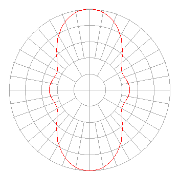
| Antenna Data for Antenna Id: 93578 WGVU-TV DT File: BLEDT-20100827ABE DIELECTRIC - TF-8HS-H P200 Service: DT Standard Pattern: Y |  | |||||||||||||||||||||||||||
| Azimuth | Ratio | Azimuth | Ratio | Azimuth | Ratio | Azimuth | Ratio | |||||||||||||||||||||
| 0 | 1.000 | 10 | 0.971 | 20 | 0.890 | 30 | 0.770 | |||||||||||||||||||||
| 40 | 0.637 | 45 | 0.575 | 50 | 0.523 | 60 | 0.462 | |||||||||||||||||||||
| 70 | 0.462 | 80 | 0.487 | 90 | 0.500 | 100 | 0.487 | |||||||||||||||||||||
| 110 | 0.462 | 120 | 0.462 | 130 | 0.523 | 135 | 0.575 | |||||||||||||||||||||
| 140 | 0.637 | 150 | 0.770 | 160 | 0.890 | 170 | 0.971 | |||||||||||||||||||||
| 180 | 1.000 | 190 | 0.971 | 200 | 0.890 | 210 | 0.770 | |||||||||||||||||||||
| 220 | 0.637 | 225 | 0.575 | 230 | 0.523 | 240 | 0.462 | |||||||||||||||||||||
| 250 | 0.462 | 260 | 0.487 | 270 | 0.500 | 280 | 0.487 | |||||||||||||||||||||
| 290 | 0.462 | 300 | 0.462 | 310 | 0.523 | 315 | 0.575 | |||||||||||||||||||||
| 320 | 0.637 | 330 | 0.770 | 340 | 0.890 | 350 | 0.971 | |||||||||||||||||||||
Structure Registration Number 1005721 [ASR Heights Differ from WGVU-TV Application] Structure Type: GTOWER Registered To: GRAND VALLEY STATE UNIVERSITY Structure Address: Pierce Rd & 48th Ave Allendale, MI County Name: Ottawa County ASR Issued: 03/14/2024 Date Built: 10/08/2020 Site Elevation: 209.7 m (688 ft.) Structure Height: 244.7 m (803 ft.) Height Overall: 261.5 m (858 ft.) Overall Height AMSL: 471.2 m (1546 ft.) FAA Determination: 10/06/2020 FAA Study #: 2020-AGL-16087-OE FAA Circular #: 70/7460-1L Paint & Light FAA Chapters: 3, 4, 5, 12 42-57-34.7 N 85-53-44.9 W (NAD 83) 42-57-34.6 N 85-53-44.8 W (Converted to NAD 27) |
WGVU 301 Fulton St. West, Room 820 Grand Rapids, MI 49504 Phone: 616-331-6666 State University | Date: 08/27/2010 Application Certifier Grand Valley State University Station WGVU 301 W. Fulton, Room 820 Grand Rapids, MI 49504-6492 Applicant Robert Lumbert Station WGVU 301 W. Fulton Grand Rapids, MI 49504 Chief Engineer Mark Van Bergh Mark Van Bergh, Esquire 2538C South Arlington Mill Drive Arlington, VA 22206 | ||||||||||||||||||||||||||
|
| |||||||||||||||||||||||||||