
FCCInfo.com
A Service of Cavell, Mertz & Associates, Inc.
(855) FCC-INFO
|
|
WPWX from 04/16/2001 |
|  |
|
|||||||||||||||
|
|
WPWX Channel: 222B 92.3 MHz Hammond, Indiana Service: FM - A full-service FM station or application. Facility ID: 17304 Fac. Service: FM Analog & Digital Status: LIC Application Accepted: 08/15/2011 Application Granted: 09/07/2011 File Number: BMLH-20110815ACZ Prefix Type: This is a modification of a license for a commecial FM station Application Type: Minor Modification FCC Website Links: LMS Facility Details This Application CDBS Application Other WPWX Applications Other WPWX Applications in CDBS Including Superseded Applications Mailing Address Correspondence for WPWX Correspondence related to application BMLH-20110815ACZ Service Contour - Open Street Map or USGS Map (54 dBu) Service Contour - KML / Google Earth (54 dBu) Public Inspection Files History Cards for WPWX Facility Type: FM STATION Class: B, A Zone I or I-A station; with 25kW-50kW ERP and a class contour distance 39km-52km Site Location: 41-37-50.1 N 87-31-40.2 W (NAD 83) Site Location: 41-37-50.0 N 87-31-40.0 W (Converted to NAD 27) Effective Radiated Power: 50 kW Transmitter Output Power: 20.73 kW Antenna Center HAAT: 150 m (492 ft.) Antenna Center AMSL: 333 m (1093 ft.) Antenna Center HAG: 154 m (505 ft.) Site Elevation: 179 m. (587 ft.) Height Overall*: 160 m (525 ft.) (* As Filed In This Application, may differ from ASR Data, Below.) Directional Antenna Antenna Make/Model: Electronics Research Inc. MP-6E-DA-HW Antenna ID: 13682 Polarization: | ||||||||||||||||||
| Antenna Data for Antenna Id: 13682 WPWX FM File: BMLH-20110815ACZ Electronics Research Inc. - MP-6E-DA-HW Service: FM | 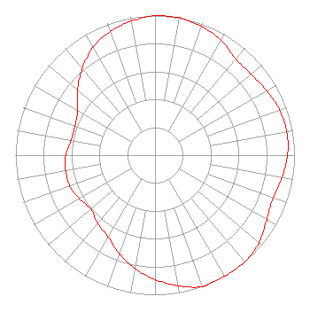 | ||||||||||||||||||
| Azimuth | Ratio | Azimuth | Ratio | Azimuth | Ratio | Azimuth | Ratio | ||||||||||||
| 0 | 1.000 | 10 | 1.000 | 20 | 0.980 | 30 | 0.950 | ||||||||||||
| 40 | 0.900 | 50 | 0.900 | 60 | 0.925 | 70 | 0.950 | ||||||||||||
| 80 | 0.960 | 90 | 0.950 | 100 | 0.925 | 110 | 0.900 | ||||||||||||
| 120 | 0.925 | 130 | 0.975 | 140 | 1.000 | 150 | 1.000 | ||||||||||||
| 160 | 1.000 | 170 | 0.950 | 180 | 0.890 | 190 | 0.825 | ||||||||||||
| 200 | 0.750 | 210 | 0.675 | 220 | 0.640 | 230 | 0.600 | ||||||||||||
| 240 | 0.625 | 250 | 0.650 | 260 | 0.650 | 270 | 0.640 | ||||||||||||
| 280 | 0.610 | 290 | 0.610 | 300 | 0.640 | 310 | 0.725 | ||||||||||||
| 320 | 0.810 | 330 | 0.890 | 340 | 0.940 | 350 | 0.975 | ||||||||||||
Structure Registration Number 1008319 Structure Type: TOWER Registered To: DONTRON INC Structure Address: 150 Marble St Burnham, IL County Name: Cook County ASR Issued: 02/04/1997 Date Built: 01/01/1986 Site Elevation: 178.6 m (586 ft.) Structure Height: 159 m (522 ft.) Height Overall: 160 m (525 ft.) Overall Height AMSL: 338.6 m (1111 ft.) FAA Determination: 02/20/1986 FAA Study #: 85-AGL-958-OE FAA Circular #: 70/7460-1F Paint & Light FAA Chapters: 3, 4, 5, 9 RED LIGHTS/PAINT 41-37-50.0 N 87-31-40.0 W (NAD 83) 41-37-49.9 N 87-31-39.8 W (Converted to NAD 27) |
P. O. Box 3003 Blue Bell, PA 19422 Phone: 215-628-3500 Corporation | Date: 08/15/2011 Application Certifier DONTRON, INC. P.o. Box 3003 Blue Bell, PA 19422 Applicant WENDELL C. ALEXANDER 2821 S. Parker Road Suite 1205 Aurora, CO 80014 DIRECTOR OF ENGINEERING JOHN NEELY, ESQ. Miller And Neely, P.c. | |||||||||||||||||
|
| ||||||||||||||||||