FCCInfo.com
A Service of Cavell, Mertz & Associates, Inc.
(855) FCC-INFO
|
|
WTEV-TV from 03/04/1996 WNFT from 06/27/1983 WXAO-TV from ??? |
Virtual Channel 47 |  |
|
|||||||||||||||||
|
|
Status: LIC Application Accepted: 03/28/2003 License Expires: 02/01/2029 File Number: BLCDT-20030328ANV Prefix Type: This is a License for a commercial digital TV station FCC Website Links: LMS Facility Details This Application Other WJAX-TV Applications Including Superseded Applications Service Contour - Open Street Map or USGS Map (41 dBu) Service Contour - KML / Google Earth (41 dBu) Public Inspection Files Rabbit Ears Info Search for WJAX-TV Site Location: 30-16-51.9 N 81-34-12.2 W (NAD 83) Site Location: 30-16-51.0 N 81-34-12.9 W (Converted to NAD 27) ERP: 1000 kW Polarization: Horizontally polarized HAAT: 291 m (955 ft.) Electrical Beam Tilt: 0.75 degrees R/C AGL: 293 m (961 ft.) R/C AMSL: 296 m (971 ft.) Site Elevation: 3 m. (10 ft.) Height Overall*: 331.3 m (1087 ft.) (* As Filed In This Application, may differ from ASR Data, Below.) Directional Antenna - Antenna Make/Model: DIELECTRIC TUC-P5-12/60H-1-B Antenna ID: 42083 Polarization: Horizontally polarized | ||||||||||||||||||||
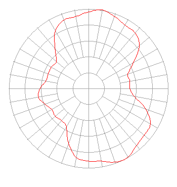
| Antenna Data for Antenna Id: 42083 WJAX-TV DT File: BLCDT-20030328ANV DIELECTRIC - TUC-P5-12/60H-1-B Service: DT Standard Pattern: Y |  | ||||||||||||||||||||
| Azimuth | Ratio | Azimuth | Ratio | Azimuth | Ratio | Azimuth | Ratio | ||||||||||||||
| 0 | 0.961 | 10 | 1.000 | 20 | 0.961 | 30 | 0.917 | ||||||||||||||
| 40 | 0.911 | 50 | 0.833 | 60 | 0.652 | 70 | 0.526 | ||||||||||||||
| 80 | 0.527 | 90 | 0.519 | 100 | 0.584 | 110 | 0.768 | ||||||||||||||
| 120 | 0.895 | 130 | 0.914 | 140 | 0.938 | 150 | 0.993 | ||||||||||||||
| 154 | 1.000 | 160 | 0.984 | 170 | 0.928 | 180 | 0.914 | ||||||||||||||
| 190 | 0.879 | 200 | 0.730 | 210 | 0.557 | 220 | 0.526 | ||||||||||||||
| 230 | 0.544 | 240 | 0.533 | 250 | 0.579 | 260 | 0.637 | ||||||||||||||
| 270 | 0.608 | 280 | 0.542 | 290 | 0.538 | 300 | 0.537 | ||||||||||||||
| 310 | 0.526 | 320 | 0.652 | 330 | 0.833 | 340 | 0.911 | ||||||||||||||
| 350 | 0.917 | ||||||||||||||||||||
Structure Registration Number 1235223 [ASR Heights Differ from WJAX-TV Application] Structure Type: GTOWER Registered To: SBA Towers II LLC Structure Address: 8675 Hogan Rd (fl10339-a) Jacksonville, FL County Name: Duval County ASR Issued: 12/20/2019 Date Built: 01/19/2006 Site Elevation: 2.4 m (8 ft.) Structure Height: 282.2 m (926 ft.) Height Overall: 317.9 m (1043 ft.) Overall Height AMSL: 320.3 m (1051 ft.) FAA Determination: 12/19/2019 FAA Study #: 2019-ASO-29338-OE FAA Circular #: 70/7460-1L Paint & Light FAA Chapters: 4, 9, 12 OM&L to remain the same as prior study = A HIGH-DUAL SYSTEM 30-16-51.9 N 81-34-12.2 W (NAD 83) 30-16-51.0 N 81-34-12.9 W (Converted to NAD 27) |
400 Ocean Road Suite 175 Vero Beach, FL 32963 Phone: 404-754-1441 Limited Liability Company | Date: 03/28/2003 Application Certifier Clear Channel Broadcasting Licenses, Inc. 2625 S Memorial Dr, Suite A Tulsa, OK 74129-2623 Applicant Jerry Randall Station Wtev-DT 11700 Central Parkway Jacksonville, FL 32224-7628 Chief Engineer Marnie K. Sarver Wiley Rein & Fielding LLP 1776 K Street, NW Washington, DC 20006 | |||||||||||||||||||