FCCInfo.com
A Service of Cavell, Mertz & Associates, Inc.
(855) FCC-INFO
|
|
WESI from 01/30/2013 WLRS from 03/01/2000 SWLXO from 03/01/2000 WLXO from 02/22/2000 WXLN-FM from 06/14/1996 WEHR from 05/11/1992 WZQE from 03/08/1991 WWQE from 03/08/1991 |
|
|
||||||||||||||||
|
|
WGHL Channel: 286A 105.1 MHz Shepherdsville, Kentucky Service: FM - A full-service FM station or application. Facility ID: 51074 FRN: 0022491476 Fac. Service: FM Analog & Digital Status: LIC 73.215 Station Application Accepted: 03/26/2008 Application Granted: 03/28/2008 File Number: BLH-20080326AEW License Expires: 08/01/2028 Prefix Type: This is a license for a commercial FM station Application Type: License To Cover FCC Website Links: LMS Facility Details This Application Other WGHL Applications Including Superseded Applications Service Contour - Open Street Map or USGS Map (60 dBu) Service Contour - KML / Google Earth (60 dBu) Public Inspection Files Facility Type: FM STATION Class: A, A Zone I; I-A; or II station; with 0.1kW-6kW ERP and a class contour distance <=28km Site Location: 38-04-55.2 N 85-47-05.9 W (NAD 83) Site Location: 38-04-55.0 N 85-47-06.0 W (Converted to NAD 27) Effective Radiated Power: 1.9 kW Transmitter Output Power: 1.41 kW Antenna Center HAAT: 180 m (591 ft.) Antenna Center AMSL: 342 m (1122 ft.) Antenna Center HAG: 84 m (276 ft.) Calculated Site Elevation: 258 m. (846 ft.) Height Overall*: 89.6 m (294 ft.) (* As Filed In This Application, may differ from ASR Data, Below.) Directional Antenna Antenna Make/Model: Shivley 6810-2D-.9SS-DA,2 sections,.9 wavelength spacing Antenna ID: 83868 Polarization: | ||||||||||||||||||
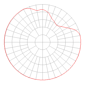
| Antenna Data for Antenna Id: 83868 WGHL FM File: BLH-20080326AEW Shivley - 6810-2D-.9SS-DA,2 sections,.9 wavelength spacing Service: FM |  | ||||||||||||||||||
| Azimuth | Ratio | Azimuth | Ratio | Azimuth | Ratio | Azimuth | Ratio | ||||||||||||
| 0 | 0.860 | 10 | 0.800 | 20 | 0.680 | 30 | 0.620 | ||||||||||||
| 40 | 0.580 | 50 | 0.640 | 60 | 0.750 | 70 | 0.920 | ||||||||||||
| 80 | 1.000 | 90 | 1.000 | 100 | 1.000 | 110 | 1.000 | ||||||||||||
| 120 | 1.000 | 130 | 1.000 | 140 | 1.000 | 150 | 1.000 | ||||||||||||
| 160 | 1.000 | 170 | 1.000 | 180 | 1.000 | 190 | 1.000 | ||||||||||||
| 200 | 1.000 | 210 | 1.000 | 220 | 1.000 | 230 | 1.000 | ||||||||||||
| 240 | 1.000 | 250 | 1.000 | 260 | 1.000 | 270 | 1.000 | ||||||||||||
| 280 | 1.000 | 290 | 1.000 | 300 | 1.000 | 310 | 1.000 | ||||||||||||
| 320 | 1.000 | 330 | 1.000 | 340 | 0.940 | 350 | 0.850 | ||||||||||||
Structure Registration Number 1023251 [ASR Heights Differ from WGHL Application] Structure Type: GTOWER Registered To: Pinnacle Towers LLC Structure Address: 1800 Top Hill Road Fairdale, KY County Name: Jefferson County ASR Issued: 05/06/2016 Date Built: 01/01/1997 Site Elevation: 258.2 m (847 ft.) Structure Height: 86.2 m (283 ft.) Height Overall: 87.2 m (286 ft.) Overall Height AMSL: 345.4 m (1133 ft.) FAA Determination: 09/11/2008 FAA Study #: 2008-ASO-4812-OE FAA Circular #: 70/7460-1K Paint & Light FAA Chapters: 3, 4, 5, 12 PRIOR STUDY 2008-ASO-109-OE 38-04-55.3 N 85-47-06.3 W (NAD 83) 38-04-55.1 N 85-47-06.4 W (Converted to NAD 27) |
1211 SW 5th Avenue Suite 750 Portland, OR 97204 Phone: 503-517-6200 | Date: 03/26/2008 Application Certifier MLB-Louisville IV, LLC 300 Conshohocken State Road Suite 380 Conshohocken, PA 19428 Applicant Clarence M. Beverage Communications Technologies, Inc. P.O. Box 1130 Marlton, NJ 08053 Broadcast Engineering Consultant Howard Liberman Drinker Biddle & Reath LLP | |||||||||||||||||
| |||||||||||||||||||