|
WHJL Channel: 201C1 88.1 MHz
Merrill, Wisconsin
Service: FM - A full-service FM station or application.
Facility ID: 176585
FRN: 0005043542
Fac. Service: FM
Status: LIC
Application Accepted: 10/03/2011
Application Granted: 01/13/2012
File Number: BLED-20111003ABZ
License Expires: 12/01/2028
Prefix Type: This is a license for a noncommercial educational FM station
Application Type: License To Cover
FCC Website Links:
LMS Facility Details
This Application
Other WHJL Applications
Including Superseded Applications
Service Contour - Open Street Map or USGS Map (60 dBu)
Service Contour - KML / Google Earth (60 dBu)
Public Inspection Files
Facility Type: NON-COMMERCIAL EDUC. FM
Class: C1, A Zone II station; with 50kW-100kW ERP and a class contour distance 52km-72km
Site Location: 45-21-07.5 N 89-39-13.2 W (NAD 83)
Site Location: 45-21-07.6 N 89-39-12.7 W (Converted to NAD 27)
Effective Radiated Power: 63 kW
Transmitter Output Power: 13 kW
Antenna Center HAAT: 189 m (620 ft.)
Antenna Center AMSL: 642 m (2106 ft.)
Antenna Center HAG: 110 m (361 ft.)
Calculated Site Elevation: 532 m. (1745 ft.)
Height Overall*: 128 m (420 ft.)
(* As Filed In This Application, may differ from ASR Data, Below.)
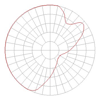
Directional Antenna
Antenna Make/Model: Propagation System Inc PSIFMR-6HC-DA, six sections
Antenna ID: 103659
Polarization:
| Associated Translators |
| W279EN(FX) |
Ch. 279 | Phelps, Wisconsin |
| W296AD(FX) |
Ch. 296 | Eagle River, Wisconsin |
| W292CG(FX) |
Ch. 292 | Land O' Lakes, Wisconsin |
| W273CQ(FX) |
Ch. 273 | Minocqua, Wisconsin |
| W208BV(FX) |
Ch. 208 | Mercer, Wisconsin |
| W254BB(FX) |
Ch. 254 | Medford, Wisconsin |
| W217BO(FX) |
Ch. 217 | Marshfield, Wisconsin |
| W266CC(FX) |
Ch. 266 | Abbotsford, Wisconsin |
| W280DT(FX) |
Ch. 280 | Lac Du Flambeau, Wisconsin |
| W272BT(FX) |
Ch. 272 | Mosinee, Wisconsin |
|
Structure Information
Structure Registration Number 1277357
Structure Type: GTOWER
Registered To:
WRVM, Inc.
Structure Address:
N6488 Irma Towers Road
Irma, WI
County Name: Lincoln County
ASR Issued: 06/11/2019
Date Built: 06/13/2019
Site Elevation: 532.2 m (1746 ft.)
Structure Height: 122.8 m (403 ft.)
Height Overall: 127.7 m (419 ft.)
Overall Height AMSL: 659.9 m (2165 ft.)
FAA Determination: 05/16/2019
FAA Study #: 2019-AGL-8224-OE
FAA Circular #: 70/7460-1L
Paint & Light FAA Chapters: 4, 8, 12
PRIOR STUDY 2010-AGL-5404-OE
45-21-07.6 N 89-39-13.0 W (NAD 83)
45-21-07.7 N 89-39-12.5 W
(Converted to NAD 27)
|
WHJL(FM) Licensee Information
WRVM, Inc.
Suring, WI 54174
Phone: 920-842-2900
Not-for-Profit | 20111003ABZ Applicant Information
Lowell Bengry
Date: 10/03/2011
Application Certifier
WRVM, Inc.
PO Box 212
Suring, WI 54174
Applicant
Alan F Kilgore, Cpbe
PO Box 212
Suring, WI 54174-0212
Chief Engineer
Alan Kilgore
WRVM, Inc.
|