FCCInfo.com
A Service of Cavell, Mertz & Associates, Inc.
(855) FCC-INFO
|
|
KMAS-TV from 04/25/2000 KSBS-TV from 11/03/1987 851016KH from ??? |
Virtual Channel 24 |  |
|
|||||||||||||||||
|
|
Status: LIC Application Accepted: 07/11/2006 License Expires: 04/01/2030 File Number: BLCDT-20060711ABO Prefix Type: This is a License for a commercial digital TV station FCC Website Links: LMS Facility Details This Application Other KRMZ Applications Including Superseded Applications Service Contour - Open Street Map or USGS Map (36 dBu) Service Contour - KML / Google Earth (36 dBu) Public Inspection Files Rabbit Ears Info Search for KRMZ Site Location: 40-27-43.0 N 106-51-00.0 W (NAD 83) Site Location: 40-27-43.1 N 106-50-57.8 W (Converted to NAD 27) ERP: 0.481 kW Polarization: Horizontally polarized HAAT: 175.2 m (575 ft.) R/C AGL: 16.2 m (53 ft.) R/C AMSL: 2532.2 m (8308 ft.) Site Elevation: 2516 m. (8255 ft.) Height Overall*: 33.5 m (110 ft.) (* As Filed In This Application, may differ from ASR Data, Below.) Directional Antenna - Antenna Make/Model: Scala 2X2 K523157-290 & 75 DEG Antenna ID: 73298 Polarization: Horizontally polarized | ||||||||||||||||||||
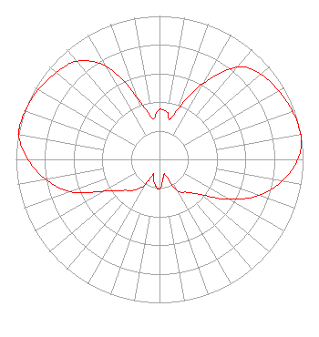
| Antenna Data for Antenna Id: 73298 KRMZ DT File: BLCDT-20060711ABO Scala - 2X2 K523157-290 & 75 DEG Service: DT Standard Pattern: Y |  | ||||||||||||||||||||
| Azimuth | Ratio | Azimuth | Ratio | Azimuth | Ratio | Azimuth | Ratio | ||||||||||||||
| 0 | 0.348 | 10 | 0.330 | 14 | 0.286 | 20 | 0.376 | ||||||||||||||
| 30 | 0.612 | 40 | 0.840 | 50 | 0.924 | 60 | 0.956 | ||||||||||||||
| 70 | 0.985 | 80 | 0.999 | 81 | 1.000 | 90 | 0.963 | ||||||||||||||
| 100 | 0.868 | 110 | 0.736 | 120 | 0.558 | 130 | 0.381 | ||||||||||||||
| 140 | 0.301 | 150 | 0.252 | 160 | 0.118 | 162 | 0.108 | ||||||||||||||
| 170 | 0.139 | 180 | 0.207 | 190 | 0.178 | 200 | 0.128 | ||||||||||||||
| 203 | 0.109 | 210 | 0.209 | 220 | 0.281 | 230 | 0.337 | ||||||||||||||
| 240 | 0.443 | 250 | 0.662 | 260 | 0.803 | 270 | 0.917 | ||||||||||||||
| 280 | 0.995 | 283 | 1.000 | 290 | 0.994 | 300 | 0.976 | ||||||||||||||
| 310 | 0.940 | 320 | 0.893 | 330 | 0.751 | 340 | 0.465 | ||||||||||||||
| 350 | 0.289 | ||||||||||||||||||||
Structure Registration Number 1023535 Structure Type: TOWER Registered To: ORTON, LYMAN Structure Address: Top Of Emerald Mountain Nr Steamboat Springs, CO County Name: Routt County ASR Issued: 09/18/1997 Date Built: 08/01/1994 Site Elevation: 2516 m (8255 ft.) Structure Height: 30.4 m (100 ft.) Height Overall: 33.5 m (110 ft.) Overall Height AMSL: 2549.5 m (8365 ft.) FAA Determination: 08/06/1997 FAA Study #: 97-ANM-0858-OE Paint & Light FAA Chapters: NONE 40-27-43.0 N 106-51-00.0 W (NAD 83) 40-27-43.1 N 106-50-57.8 W (Converted to NAD 27) |
Buell Media Center 2101 Arapahoe Street Denver, CO 80205 Phone: 303-892-6666 Not-for-Profit | Date: 07/11/2006 Application Certifier NBC Telemundo License Co. 1299 Pennsylvania Avenue, NW Washington, DC 20004 Applicant H. Douglas Lung PO Box 98 Honomu, HI 96728-0098 Corporate Engineering Manager F. William Lebeau NBC Telemundo License Co. 1299 Pennsylvania Avenue, NW Washington, DC 20004 | |||||||||||||||||||