FCCInfo.com
A Service of Cavell, Mertz & Associates, Inc.
(855) FCC-INFO
|
|
|
|
|
||||||||||||||||
|
|
K229AX Channel: 229D 93.7 MHz John Day, Oregon Service: FX - A translator or application for a translator. Facility ID: 141813 FRN: 0024760910 Fac. Service: FX Programming Delivery Method: Unspecified Status: LIC Application Accepted: 03/08/2005 Application Granted: 02/23/2006 File Number: BLFT-20050308AAZ License Expires: 02/01/2030 Prefix Type: This is a license for a translator Application Type: Amendment FCC Website Links: LMS Facility Details This Application CDBS Application Other K229AX Applications Other K229AX Applications in CDBS Including Superseded Applications Mailing Address Correspondence for K229AX Correspondence related to application BLFT-20050308AAZ Service Contour - Open Street Map or USGS Map (60 dBu) Service Contour - KML / Google Earth (60 dBu) Class: D, A Noncommercial educational operating with no more than 10W Site Location: 44-26-02.6 N 118-57-32.8 W (NAD 83) Site Location: 44-26-03.0 N 118-57-29.0 W (Converted to NAD 27) Effective Radiated Power: 0.22 kW Transmitter Output Power: 0.064 kW Antenna Center HAAT: -76.8 m Horiz.; 0 m Vert. Antenna Center AMSL: 1193 m (3914 ft.) Antenna Center HAG: 7 m (23 ft.) Site Elevation: 1186 m. (3891 ft.) Height Overall*: 22 m (72 ft.) (* As Filed In This Application, may differ from ASR Data, Below.) Directional Antenna Antenna Make/Model: None Antenna ID: 16149 Polarization:
| ||||||||||||||||||
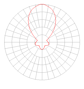
| Antenna Data for Antenna Id: 16149 K229AX FX File: BLFT-20050308AAZ None - Service: FX |  | ||||||||||||||||||
| Azimuth | Ratio | Azimuth | Ratio | Azimuth | Ratio | Azimuth | Ratio | ||||||||||||
| 0 | 1.000 | 10 | 0.952 | 20 | 0.866 | 30 | 0.718 | ||||||||||||
| 40 | 0.528 | 50 | 0.329 | 60 | 0.190 | 70 | 0.134 | ||||||||||||
| 80 | 0.142 | 90 | 0.157 | 100 | 0.181 | 110 | 0.187 | ||||||||||||
| 120 | 0.171 | 130 | 0.140 | 140 | 0.123 | 150 | 0.135 | ||||||||||||
| 160 | 0.160 | 170 | 0.182 | 180 | 0.193 | 190 | 0.182 | ||||||||||||
| 200 | 0.160 | 210 | 0.135 | 220 | 0.123 | 230 | 0.140 | ||||||||||||
| 240 | 0.171 | 250 | 0.187 | 260 | 0.181 | 270 | 0.157 | ||||||||||||
| 280 | 0.142 | 290 | 0.134 | 300 | 0.190 | 310 | 0.329 | ||||||||||||
| 320 | 0.528 | 330 | 0.718 | 340 | 0.866 | 350 | 0.952 | ||||||||||||
Structure Registration Number 1035566 Structure Type: GTOWER Registered To: CSN International Structure Address: Holmstrom Ranch Antenna Site John Day, OR County Name: Grant County ASR Issued: 05/18/2021 Date Built: 07/13/2015 Site Elevation: 1185.7 m (3890 ft.) Structure Height: 22.2 m (73 ft.) Height Overall: 22.2 m (73 ft.) Overall Height AMSL: 1207.9 m (3963 ft.) FAA Determination: 05/20/1993 FAA Study #: 93-ANM-0445-OE Paint & Light FAA Chapters: NONE 44-26-03.0 N 118-57-32.0 W (NAD 83) 44-26-03.4 N 118-57-28.2 W (Converted to NAD 27) |
61043 Longview Lane Cove, OR 97824 Phone: 541-786-5223 Limited Liability Company | Date: 03/08/2005 Application Certifier Blue Mountain Broadcasting Company, Inc. P.O. Box 399 413 NW Bridge Street John Day, OR 97845 Applicant J. Dominic Monahan Luvaas Cobb Suite 300 777 High Street Eugene, OR 97401-2787 Robert A. McClanathan Post Office Box 939 Portland, OR 97207 Consulting Engeineer | |||||||||||||||||