|
WBJB-FM
Call Sign History
WBJB-FM from 11/24/1978
WBJBFM from ???
|
90.5 MHz
|
Lincroft, NJ
|
|
WBJB-FM Channel: 213A 90.5 MHz
Lincroft, New Jersey
Service: FM - A full-service FM station or application.
Facility ID: 7116
FRN: 0008300824
Fac. Service: FM Analog & Digital
Status: LIC
Application Accepted: 11/23/1998
Application Granted: 03/08/1999
File Number: BLED-19981123KD
License Expires: 06/01/2030
Prefix Type: This is a license for a noncommercial educational FM station
Application Type: License To Cover
FCC Website Links:
LMS Facility Details
This Application
Other WBJB-FM Applications
Including Superseded Applications
Service Contour - Open Street Map or USGS Map (60 dBu)
Service Contour - KML / Google Earth (60 dBu)
Public Inspection Files
Facility Type: NON-COMMERCIAL EDUC. FM
Class: A, A Zone I; I-A; or II station; with 0.1kW-6kW ERP and a class contour distance <=28km
Site Location: 40-19-19.4 N 74-07-55.5 W (NAD 83)
Site Location: 40-19-19.0 N 74-07-57.0 W (Converted to NAD 27)
Effective Radiated Power: 0.9 kW
Antenna Center HAAT: 113 m (371 ft.)
Antenna Center AMSL: 140 m (459 ft.)
Antenna Center HAG: 122 m (400 ft.)
Calculated Site Elevation: 18 m. (59 ft.)
Height Overall*: 127 m (417 ft.)
(* As Filed In This Application, may differ from ASR Data, Below.)
Directional Antenna
Antenna Make/Model: Oddball; usually designed by Applicant ODD980304IB
Antenna ID: 15508
Polarization:
|
Antenna Data for Antenna Id: 15508
WBJB-FM FM File: BLED-19981123KD
Oddball; usually designed by Applicant - ODD980304IB
Service: FM
|
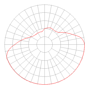 |
| Azimuth | Ratio | Azimuth | Ratio | Azimuth | Ratio | Azimuth | Ratio |
| 0 | 0.390 | 10 | 0.420 | 20 | 0.440 | 30 | 0.430 |
| 40 | 0.430 | 50 | 0.470 | 60 | 0.590 | 70 | 0.740 |
| 80 | 0.930 | 90 | 1.000 | 100 | 1.000 | 110 | 1.000 |
| 120 | 1.000 | 130 | 1.000 | 140 | 1.000 | 150 | 1.000 |
| 160 | 1.000 | 170 | 1.000 | 180 | 1.000 | 190 | 1.000 |
| 200 | 1.000 | 210 | 1.000 | 220 | 1.000 | 230 | 1.000 |
| 240 | 1.000 | 250 | 1.000 | 260 | 0.920 | 270 | 0.742 |
| 280 | 0.590 | 290 | 0.469 | 300 | 0.382 | 310 | 0.345 |
| 320 | 0.330 | 330 | 0.330 | 340 | 0.330 | 350 | 0.330 |
|
Structure Information
Structure Registration Number 1046073
[ASR Heights Differ from WBJB-FM Application]
Structure Type: GTOWER
Registered To:
Atlantic Coast Communications LLC
Structure Address:
765 Newman Springs Road
Lincroft, NJ
County Name: Monmouth County
ASR Issued: 06/30/2022
Date Built: 01/23/2001
Site Elevation: 20.4 m (67 ft.)
Structure Height: 125 m (410 ft.)
Height Overall: 127.7 m (419 ft.)
Overall Height AMSL: 148.1 m (486 ft.)
FAA Determination: 09/21/2018
FAA Study #: 2018-AEA-11178-OE
FAA Circular #: 70/7460-1K
Paint & Light FAA Chapters: 4, 8, 12
PRIOR STUDY 2008-AEA-4973-OE
40-19-15.9 N 74-07-49.9 W (NAD 83)
40-19-15.5 N 74-07-51.4 W
(Converted to NAD 27)
|
WBJB-FM Licensee Information
Brookdale Community College
765 Newman Springs Road
Lincroft, NJ 07738
Phone: 732-224-2473
Government Entity | 19981123KD Applicant Information
Date: 11/23/1998
Application Certifier
Brookdale Community College
Brookdale Community College
765 Newman Springs Road
Lincroft, NJ 07738
Applicant
|
Associated Land Mobile Licenses
|
| (No Records Found) |
| Associated Microwave Licenses
|
| | WLD917 |
950 MHz Aural Studio Transmitter Link |
|
