
FCCInfo.com
A Service of Cavell, Mertz & Associates, Inc.
(855) FCC-INFO
|
|
|
|  |
|
||||||||||||||||||
|
|
WNKO Channel: 269B1 101.7 MHz New Albany, Ohio Service: FM - A full-service FM station or application. Facility ID: 57936 Fac. Service: FM Analog & Digital Status: LIC 73.215 Station Application Accepted: 03/30/2011 Application Granted: 04/11/2011 File Number: BLH-20110330AAG Prefix Type: This is a license for a commercial FM station Application Type: License To Cover FCC Website Links: LMS Facility Details This Application CDBS Application Other WNKO Applications Other WNKO Applications in CDBS Including Superseded Applications Mailing Address Correspondence for WNKO Correspondence related to application BLH-20110330AAG Service Contour - Open Street Map or USGS Map (57 dBu) Service Contour - KML / Google Earth (57 dBu) Public Inspection Files History Cards for WNKO Facility Type: FM STATION Class: B1, A Zone I or I-A station; with 6kW-25kW ERP and a class contour distance 28km-39km Site Location: 40-08-38.2 N 82-38-19.6 W (NAD 83) Site Location: 40-08-38.0 N 82-38-20.0 W (Converted to NAD 27) Effective Radiated Power: 22 kW Transmitter Output Power: 8.6 kW Antenna Center HAAT: 107 m (351 ft.) Antenna Center AMSL: 448.1 m (1470 ft.) Antenna Center HAG: 107.1 m (351 ft.) Calculated Site Elevation: 341 m. (1119 ft.) Height Overall*: 115.8 m (380 ft.) (* As Filed In This Application, may differ from ASR Data, Below.) Directional Antenna Antenna Make/Model: Electronics Research Inc. MP-6E-DA-HW Antenna ID: 102643 Polarization: | |||||||||||||||||||||
| Antenna Data for Antenna Id: 102643 WNKO FM File: BLH-20110330AAG Electronics Research Inc. - MP-6E-DA-HW Service: FM | 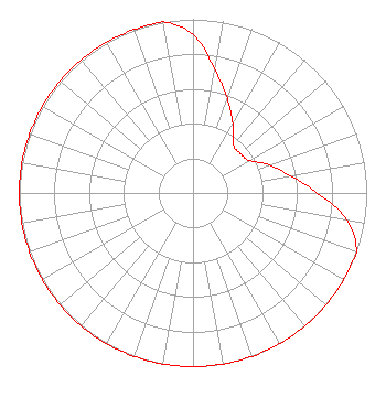 | |||||||||||||||||||||
| Azimuth | Ratio | Azimuth | Ratio | Azimuth | Ratio | Azimuth | Ratio | |||||||||||||||
| 0 | 0.911 | 10 | 0.724 | 20 | 0.576 | 30 | 0.458 | |||||||||||||||
| 40 | 0.364 | 50 | 0.354 | 60 | 0.375 | 70 | 0.471 | |||||||||||||||
| 80 | 0.569 | 90 | 0.716 | 100 | 0.901 | 110 | 1.000 | |||||||||||||||
| 120 | 1.000 | 130 | 1.000 | 140 | 1.000 | 150 | 1.000 | |||||||||||||||
| 160 | 1.000 | 170 | 1.000 | 180 | 1.000 | 190 | 1.000 | |||||||||||||||
| 200 | 1.000 | 210 | 1.000 | 220 | 1.000 | 230 | 1.000 | |||||||||||||||
| 240 | 1.000 | 250 | 1.000 | 260 | 1.000 | 270 | 1.000 | |||||||||||||||
| 280 | 1.000 | 290 | 1.000 | 300 | 1.000 | 310 | 1.000 | |||||||||||||||
| 320 | 1.000 | 330 | 1.000 | 340 | 1.000 | 350 | 1.000 | |||||||||||||||
Structure Registration Number 1276414 Structure Type: TOWER Registered To: Runnymede, Inc. Structure Address: 2.5 Miles East Of Johnstown, Ohio In Licking County. Site Is At The Nw Corner Of Johnstown, OH County Name: Licking County ASR Issued: 10/20/2010 Date Built: 01/25/2011 Site Elevation: 340.8 m (1118 ft.) Structure Height: 115.8 m (380 ft.) Height Overall: 115.8 m (380 ft.) Overall Height AMSL: 456.6 m (1498 ft.) FAA Determination: 09/07/2010 FAA Study #: 2010-AGL-4203-OE FAA Circular #: 70/7460-1K Paint & Light FAA Chapters: 3, 4, 5, 12 Removed expiration date from determination. Scenario 1./jjs/case#635066 40-08-38.1 N 82-38-19.5 W (NAD 83) 40-08-37.9 N 82-38-19.9 W (Converted to NAD 27) |
Newark, OH 43058 Phone: 740-522-8171 Corporation | Date: 03/30/2011 Application Certifier RUNNYMEDE, INC. P.o. Box 1057 Newark, OH 43058-1057 Applicant DONALD LYNCH 111 Sam Houston Dr. Kerrville, TX 78028 TECHNICAL CONSULTANT JOHN FRANKS Runnymede, Inc. | ||||||||||||||||||||
| ||||||||||||||||||||||