FCCInfo.com
A Service of Cavell, Mertz & Associates, Inc.
(855) FCC-INFO
|
|
KSBW-TV from 07/28/1978 KSBW from ??? |
Virtual Channel 8 |  |
|
|||||||||||||||||||||||||||||||||||||||||||||||||||||||||||||||
|
|
Status: LIC Application Accepted: 11/12/2009 License Expires: 12/01/2030 File Number: BXLCDT-20091112ABJ Prefix Type: This is BXLCDT FCC Website Links: LMS Facility Details This Application Other KSBW Applications Including Superseded Applications Service Contour - Open Street Map or USGS Map (36 dBu) Service Contour - KML / Google Earth (36 dBu) Public Inspection Files Rabbit Ears Info Search for KSBW Site Location: 36-45-22.8 N 121-30-08.7 W (NAD 83) Site Location: 36-45-22.9 N 121-30-04.9 W (Converted to NAD 27) ERP: 19.2 kW Polarization: Horizontally polarized HAAT: 736 m (2415 ft.) R/C AGL: 96 m (315 ft.) R/C AMSL: 1034 m (3392 ft.) Site Elevation: 938 m. (3077 ft.) Height Overall*: 122.5 m (402 ft.) (* As Filed In This Application, may differ from ASR Data, Below.) Directional Antenna - Antenna Make/Model: DIELECTRIC THA-SP4-4H/16H-1-R Antenna ID: 96013 Polarization: Horizontally polarized | ||||||||||||||||||||||||||||||||||||||||||||||||||||||||||||||||||
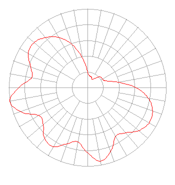
| Antenna Data for Antenna Id: 96013 KSBW DX File: BXLCDT-20091112ABJ DIELECTRIC - THA-SP4-4H/16H-1-R Service: DX Standard Pattern: Y |  | ||||||||||||||||||||||||||||||||||||||||||||||||||||||||||||||||||
| Azimuth | Ratio | Azimuth | Ratio | Azimuth | Ratio | Azimuth | Ratio | ||||||||||||||||||||||||||||||||||||||||||||||||||||||||||||
| 0 | 0.199 | 10 | 0.151 | 20 | 0.143 | 30 | 0.118 | ||||||||||||||||||||||||||||||||||||||||||||||||||||||||||||
| 40 | 0.155 | 50 | 0.209 | 60 | 0.219 | 70 | 0.246 | ||||||||||||||||||||||||||||||||||||||||||||||||||||||||||||
| 80 | 0.390 | 90 | 0.613 | 100 | 0.785 | 110 | 0.879 | ||||||||||||||||||||||||||||||||||||||||||||||||||||||||||||
| 120 | 0.902 | 130 | 0.851 | 140 | 0.752 | 150 | 0.716 | ||||||||||||||||||||||||||||||||||||||||||||||||||||||||||||
| 160 | 0.862 | 170 | 0.948 | 180 | 0.829 | 190 | 0.701 | ||||||||||||||||||||||||||||||||||||||||||||||||||||||||||||
| 200 | 0.761 | 210 | 0.868 | 220 | 0.848 | 230 | 0.734 | ||||||||||||||||||||||||||||||||||||||||||||||||||||||||||||
| 240 | 0.711 | 250 | 0.901 | 260 | 1.000 | 270 | 0.870 | ||||||||||||||||||||||||||||||||||||||||||||||||||||||||||||
| 280 | 0.720 | 290 | 0.768 | 300 | 0.869 | 310 | 0.886 | ||||||||||||||||||||||||||||||||||||||||||||||||||||||||||||
| 320 | 0.827 | 330 | 0.735 | 340 | 0.585 | 350 | 0.383 | ||||||||||||||||||||||||||||||||||||||||||||||||||||||||||||
Structure Registration Number 1215158 Structure Type: LTOWER Registered To: Hearst Stations Inc. Structure Address: Fremont Peak, Approximatley 16 Km Northeast Of Salinas San Juan Bautis, CA County Name: Monterey County ASR Issued: 11/22/2016 Date Built: 12/05/2002 Site Elevation: 937.8 m (3077 ft.) Structure Height: 121.6 m (399 ft.) Height Overall: 122.5 m (402 ft.) Overall Height AMSL: 1060.3 m (3479 ft.) FAA Determination: 03/19/1999 FAA Study #: 99-AWP-0164-OE FAA Circular #: 70/7460-1J Paint & Light FAA Chapters: 3, 4, 5, 13 36-45-22.8 N 121-30-08.7 W (NAD 83) 36-45-22.9 N 121-30-04.9 W (Converted to NAD 27) |
P.O. Box 1800 Raleigh, NC 27602 Phone: 919-839-0300 Corporation | Date: 11/12/2009 Application Certifier Hearst Stations Inc. C/O Brooks, Pierce, Et AL. P.O. Box 1800 Raleigh, NC 27602 Applicant Bernard R. Segal, P.E. 3612 Sandy Court Kensington, MD 20895-1421 Consulting Engineer Mark J. Prak Brooks, Pierce, Et Al. | |||||||||||||||||||||||||||||||||||||||||||||||||||||||||||||||||
|
| ||||||||||||||||||||||||||||||||||||||||||||||||||||||||||||||||||