FCCInfo.com
A Service of Cavell, Mertz & Associates, Inc.
(855) FCC-INFO
|
|
KLEW from ??? |
Virtual Channel 3 |
|
||||||||||||||||||||||||||||||||||||||||
|
|
Status: LIC Application Accepted: 01/11/2010 License Expires: 10/01/2030 File Number: BLCDT-20100111ADM Prefix Type: This is a License for a commercial digital TV station FCC Website Links: LMS Facility Details This Application Other KLEW-TV Applications Including Superseded Applications Service Contour - Open Street Map or USGS Map (41 dBu) Service Contour - KML / Google Earth (41 dBu) Public Inspection Files Rabbit Ears Info Search for KLEW-TV Site Location: 46-27-27.0 N 117-06-00.0 W (NAD 83) Site Location: 46-27-27.4 N 117-05-56.4 W (Converted to NAD 27) ERP: 133 kW Polarization: Horizontally polarized HAAT: 349 m (1145 ft.) Electrical Beam Tilt: 1 degree R/C AGL: 48 m (157 ft.) R/C AMSL: 939 m (3081 ft.) Site Elevation: 891 m. (2923 ft.) Height Overall*: 92 m (302 ft.) (* As Filed In This Application, may differ from ASR Data, Below.) Directional Antenna - Antenna Make/Model: DIELECTRIC TLP-16M Antenna ID: 96215 Polarization: Horizontally polarized
| ||||||||||||||||||||||||||||||||||||||||||
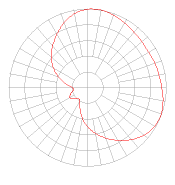
| Antenna Data for Antenna Id: 96215 KLEW-TV DT File: BLCDT-20100111ADM DIELECTRIC - TLP-16M Service: DT Standard Pattern: Y |  | ||||||||||||||||||||||||||||||||||||||||||
| Azimuth | Ratio | Azimuth | Ratio | Azimuth | Ratio | Azimuth | Ratio | ||||||||||||||||||||||||||||||||||||
| 0 | 0.993 | 6 | 1.000 | 10 | 0.998 | 20 | 0.976 | ||||||||||||||||||||||||||||||||||||
| 30 | 0.944 | 40 | 0.918 | 50 | 0.901 | 60 | 0.895 | ||||||||||||||||||||||||||||||||||||
| 70 | 0.908 | 80 | 0.921 | 90 | 0.942 | 100 | 0.974 | ||||||||||||||||||||||||||||||||||||
| 110 | 0.995 | 120 | 0.985 | 130 | 0.940 | 140 | 0.865 | ||||||||||||||||||||||||||||||||||||
| 150 | 0.775 | 160 | 0.684 | 170 | 0.593 | 180 | 0.497 | ||||||||||||||||||||||||||||||||||||
| 190 | 0.392 | 200 | 0.280 | 210 | 0.197 | 220 | 0.184 | ||||||||||||||||||||||||||||||||||||
| 230 | 0.226 | 240 | 0.257 | 250 | 0.227 | 260 | 0.183 | ||||||||||||||||||||||||||||||||||||
| 270 | 0.194 | 280 | 0.278 | 290 | 0.393 | 300 | 0.502 | ||||||||||||||||||||||||||||||||||||
| 310 | 0.599 | 320 | 0.688 | 330 | 0.778 | 340 | 0.873 | ||||||||||||||||||||||||||||||||||||
| 350 | 0.951 | ||||||||||||||||||||||||||||||||||||||||||
Structure Registration Number 1032600 Structure Type: Registered To: SINCLAIR LEWISTON LICENSEE, LLC Structure Address: 2.5 Mi Sw Of Us 195 3 Mi Nw Clarkston, WA County Name: Whitman County ASR Issued: 01/11/2017 Date Built: 12/01/1955 Site Elevation: 891 m (2923 ft.) Structure Height: 76 m (249 ft.) Height Overall: 92 m (302 ft.) Overall Height AMSL: 983 m (3225 ft.) FAA Determination: 03/10/1989 FAA Study #: 89-ANM-0022-OE FAA Circular #: 70/7460-1G Paint & Light FAA Chapters: 3, 4, 5, 9 RED LIGHTS/PAINT 46-27-27.0 N 117-06-00.0 W (NAD 83) 46-27-27.4 N 117-05-56.4 W (Converted to NAD 27) |
1200 Seventeenth Street NW Washington, DC 20036 Phone: 202-663-8195 Limited Liability Company | Date: 01/11/2010 Application Certifier Fisher Broadcasting - Washington TV, L.L.C. 100 Fourth Avenue North Suite 510 Seattle, WA 98109 Applicant Lee Wood Fisher Communications 2153 NE Sandy Blvd Portland, OR 97221 Regional Director of Engineering Wade H. Hargrove Brooks, Pierce, Et. Al. | |||||||||||||||||||||||||||||||||||||||||
|
| ||||||||||||||||||||||||||||||||||||||||||