FCCInfo.com
A Service of Cavell, Mertz & Associates, Inc.
(855) FCC-INFO
|
|
|
|
|
||||||||||||||||
|
|
Status: LIC Application Accepted: 05/01/2014 License Expires: 06/01/2030 File Number: BLDTL-20140501AAZ Prefix Type: This is BLDTL FCC Website Links: LMS Facility Details This Application Other K32JQ-D Applications Including Superseded Applications Service Contour - Open Street Map or USGS Map (51 dBu) Service Contour - KML / Google Earth (51 dBu) Rabbit Ears Info Search for K32JQ-D Site Location: 39-13-34.0 N 96-37-01.0 W (NAD 83) Site Location: 39-13-34.0 N 96-36-60.0 W (Converted to NAD 27) ERP: 1 kW R/C AGL: 85 m (279 ft.) R/C AMSL: 474.5 m (1557 ft.) Emission Mask: Stringent Site Elevation: 389.5 m. (1278 ft.) Height Overall*: 92.4 m (303 ft.) (* As Filed In This Application, may differ from ASR Data, Below.) Directional Antenna - Antenna Make/Model: MICRO COMMUNICATIONS INC 955312 Antenna ID: 20058 | ||||||||||||||||||
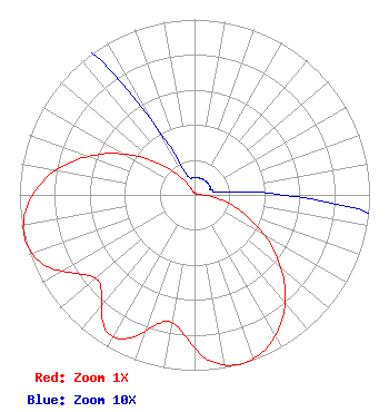
| Antenna Data for Antenna Id: 20058 K32JQ-D LD File: BLDTL-20140501AAZ MICRO COMMUNICATIONS INC - 955312 Service: LD Standard Pattern: Y Pattern and Field Values Include a 165° Clockwise Rotation |  | ||||||||||||||||||
| Azimuth | Ratio | Azimuth | Ratio | Azimuth | Ratio | Azimuth | Ratio | ||||||||||||
| 5 | 0.010 | 15 | 0.010 | 25 | 0.010 | 35 | 0.010 | ||||||||||||
| 45 | 0.010 | 55 | 0.010 | 65 | 0.010 | 75 | 0.010 | ||||||||||||
| 85 | 0.021 | 95 | 0.094 | 105 | 0.218 | 115 | 0.378 | ||||||||||||
| 125 | 0.556 | 135 | 0.729 | 145 | 0.872 | 155 | 0.967 | ||||||||||||
| 165 | 1.000 | 175 | 0.947 | 185 | 0.793 | 190 | 0.740 | ||||||||||||
| 195 | 0.756 | 205 | 0.902 | 210 | 0.933 | 215 | 0.902 | ||||||||||||
| 225 | 0.756 | 230 | 0.740 | 235 | 0.793 | 245 | 0.947 | ||||||||||||
| 255 | 1.000 | 265 | 0.967 | 275 | 0.872 | 285 | 0.729 | ||||||||||||
| 295 | 0.556 | 305 | 0.378 | 315 | 0.218 | 325 | 0.094 | ||||||||||||
| 335 | 0.021 | 345 | 0.010 | 355 | 0.010 | ||||||||||||||
Structure Registration Number 1033059 Structure Type: TOWER Registered To: MANHATTAN BROADCASTING CO INC DBA = KMAN-AM / KMKF-FM RADIO Structure Address: .5 Km N Int Marlatt & Seth Childs Manhattan, KS County Name: Riley County ASR Issued: 12/16/1997 Date Built: 01/01/1971 Site Elevation: 389.5 m (1278 ft.) Structure Height: 92.4 m (303 ft.) Height Overall: 92.4 m (303 ft.) Overall Height AMSL: 481.9 m (1581 ft.) FAA Determination: 09/22/1971 FAA Study #: 71-CE-368-OE Paint & Light FAA Chapters: 1, 3, 12, 21 RED LIGHTS/PAINT 39-13-34.0 N 96-37-01.0 W (NAD 83) 39-13-34.0 N 96-36-60.0 W (Converted to NAD 27) |
Hurst, TX 76054-4025 Phone: 214-770-7770 Corporation | Date: 05/01/2014 Application Certifier EICB-TV East, LLC PO Box 54025 Hurst, TX 76054-4025 Applicant B. W. St. Clair 2355 Ranch Drive Westminster, CO 80234 Engineering Consultant Dr. Randy Weiss EICB-TV East, LLC | |||||||||||||||||