
FCCInfo.com
A Service of Cavell, Mertz & Associates, Inc.
(855) FCC-INFO
|
|
W241CF from 10/18/2011 W241CF from 07/08/1997 |
|
|
||||||||||||||||
|
|
W241CF Channel: 241D 96.1 MHz Taylorville, Illinois Service: FX - A translator or application for a translator. Facility ID: 85685 Fac. Service: FX Programming Delivery Method: Unspecified Status: LIC Application Accepted: 10/18/2018 Application Granted: 10/23/2018 File Number: BLFT-20181018AAG Prefix Type: This is a license for a translator Application Type: License To Cover FCC Website Links: LMS Facility Details This Application CDBS Application Other W241CF Applications Other W241CF Applications in CDBS Including Superseded Applications Mailing Address Correspondence for W241CF Correspondence related to application BLFT-20181018AAG Service Contour - Open Street Map or USGS Map (60 dBu) Service Contour - KML / Google Earth (60 dBu) Class: D, A Noncommercial educational operating with no more than 10W Site Location: 39-27-08.2 N 89-17-10.3 W (NAD 83) Site Location: 39-27-08.0 N 89-17-10.0 W (Converted to NAD 27) Effective Radiated Power: 0.25 kW Transmitter Output Power: 0.35 kW Antenna Center HAAT: 0 m Antenna Center AMSL: 286 m (938 ft.) Antenna Center HAG: 81 m (266 ft.) Site Elevation: 205 m. (673 ft.) Height Overall*: 105 m (344 ft.) (* As Filed In This Application, may differ from ASR Data, Below.) Directional Antenna Antenna Make/Model: None Antenna ID: 133606 Polarization:
| ||||||||||||||||||
| Antenna Data for Antenna Id: 133606 W241CF FX File: BLFT-20181018AAG None - Service: FX | 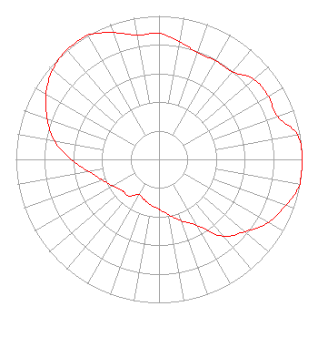 | ||||||||||||||||||
| Azimuth | Ratio | Azimuth | Ratio | Azimuth | Ratio | Azimuth | Ratio | ||||||||||||
| 0 | 0.880 | 10 | 0.833 | 20 | 0.793 | 30 | 0.793 | ||||||||||||
| 40 | 0.799 | 50 | 0.867 | 60 | 0.880 | 70 | 0.880 | ||||||||||||
| 80 | 0.984 | 90 | 1.000 | 100 | 1.000 | 110 | 0.943 | ||||||||||||
| 120 | 0.880 | 130 | 0.784 | 140 | 0.698 | 150 | 0.529 | ||||||||||||
| 160 | 0.456 | 170 | 0.392 | 180 | 0.348 | 190 | 0.324 | ||||||||||||
| 200 | 0.300 | 210 | 0.283 | 220 | 0.332 | 230 | 0.337 | ||||||||||||
| 240 | 0.373 | 250 | 0.421 | 260 | 0.493 | 270 | 0.614 | ||||||||||||
| 280 | 0.741 | 290 | 0.832 | 300 | 0.912 | 310 | 0.971 | ||||||||||||
| 320 | 1.000 | 330 | 1.000 | 340 | 0.940 | 350 | 0.880 | ||||||||||||
Structure Registration Number 1219448 Structure Type: TOWER Registered To: Miller Communications Inc Structure Address: Appx 5 1/2 Miles Southeast Of Clarksdale Il Clarksdale, IL County Name: Christian County ASR Issued: 11/08/2000 Date Built: 11/26/2001 Site Elevation: 205 m (673 ft.) Structure Height: 104 m (341 ft.) Height Overall: 105 m (344 ft.) Overall Height AMSL: 310 m (1017 ft.) FAA Determination: 10/18/2000 FAA Study #: 00-AGL-6444-OE FAA Circular #: 70/7460-1K Paint & Light FAA Chapters: 4, 6, 12 39-27-08.2 N 89-17-10.3 W (NAD 83) 39-27-08.0 N 89-17-10.0 W (Converted to NAD 27) |
918 East Park P.o. Box 169 Taylorville, IL 62568 Phone: 217-824-3395 | Date: 10/18/2018 Application Certifier MILLER COMMUNICATIONS, INC. P.o. Box 169 Taylorvillle, IL 62568-0169 Applicant JIM TURVAVILLE Turbo Tech Services 360 Patton Street - Po Box 144 Mobeetie, TX 79061-0144 CONSULTING ENGINEER JOHN GARZIGLIA. Womble Carlyle Sandridge & Rice, Pllc 1401 I Street, N.w. Suite 700 Washington, DC 20005 | |||||||||||||||||