|
WXTP Channel: 294A 106.7 MHz
North Windham, Maine
Service: FM - A full-service FM station or application.
Facility ID: 59534
FRN: 0005032248
Fac. Service: FM
Status: LIC
73.215 Station
Application Accepted: 05/15/2012
Application Granted: 08/17/2012
File Number: BMLED-20120515ABK
License Expires: 04/01/2030
Prefix Type: This is a modification of license for a noncommercial educational FM station
Application Type: Minor Modification
FCC Website Links:
LMS Facility Details
This Application
Other WXTP Applications
Including Superseded Applications
Service Contour - Open Street Map or USGS Map (60 dBu)
Service Contour - KML / Google Earth (60 dBu)
Public Inspection Files
Facility Type: NON-COMMERCIAL EDUC. FM
Class: A, A Zone I; I-A; or II station; with 0.1kW-6kW ERP and a class contour distance <=28km
Site Location: 43-51-06.3 N 70-19-38.2 W (NAD 83)
Site Location: 43-51-06.0 N 70-19-40.0 W (Converted to NAD 27)
Effective Radiated Power: 0.81 kW
Transmitter Output Power: 0.746 kW
Antenna Center HAAT: 190 m (623 ft.)
Antenna Center AMSL: 268 m (879 ft.)
Antenna Center HAG: 122 m (400 ft.)
Site Elevation: 146.3 m. (480 ft.)
Height Overall*: 222.8 m (731 ft.)
(* As Filed In This Application, may differ from ASR Data, Below.)
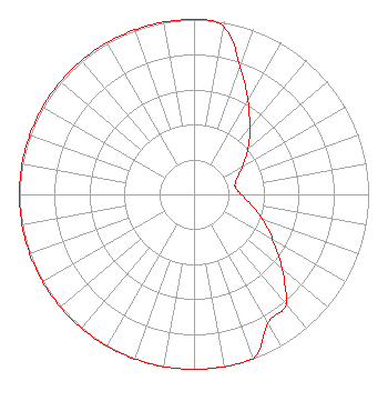
Directional Antenna
Antenna Make/Model: Shivley 6106-1/3 DA
Antenna ID: 13929
Polarization:
| Associated Translators |
| WXBP(FM) |
Ch. 212 | Corinth, Maine |
|
Structure Information
Structure Registration Number 1022679
[ASR Heights Differ from WXTP Application]
Structure Type: TOWER
Registered To:
SpectraSite Communications, LLC. through American Towers, LLC.
Structure Address:
Eagle Nest Rd (305316)
Gray, ME
County Name: Cumberland County
ASR Issued: 01/15/2013
Date Built: 01/31/2007
Site Elevation: 139.5 m (458 ft.)
Structure Height: 210.3 m (690 ft.)
Height Overall: 223.4 m (733 ft.)
Overall Height AMSL: 362.9 m (1191 ft.)
FAA Determination: 09/19/2011
FAA Study #: 2011-ANE-1508-OE
FAA Circular #: 70/7460-1K
Paint & Light FAA Chapters: 4, 7, 12
OM&L to remain the same as prior study = 24-HR HI-STROBES
43-51-06.0 N 70-19-37.5 W (NAD 83)
43-51-05.7 N 70-19-39.3 W
(Converted to NAD 27)
|
WXTP(FM) Licensee Information
Relevant Radio, Inc.
680 Barclay Boulevard
Lincolnshire, IL 60069
Phone: 877-291-0123
Not-for-Profit | 20120515ABK Applicant Information
Roger Pomerleau
Date: 05/15/2012
Application Certifier
The Presence Radio Network, Inc.
Post Office Box 10660
Portland, ME 04104-6060
Applicant
Robert Walker
Post Office Box 28961
Austin, TX 78755
Attorney/Consultant
Dennis J. Kelly
Law Office of Dennis J. Kelly
|