FCCInfo.com
A Service of Cavell, Mertz & Associates, Inc.
(855) FCC-INFO
|
|
960920JZ from 09/20/1996 |
Virtual Channel 12 |  |
|
||||||||||||||||||||||||||||||||||||
|
|
Status: LIC Application Accepted: 06/15/2009 License Expires: 06/01/2029 File Number: BLEDT-20090615ABU Prefix Type: This is a license for a noncommercial educational digital TV station FCC Website Links: LMS Facility Details This Application Other KETZ Applications Including Superseded Applications Service Contour - Open Street Map or USGS Map (36 dBu) Service Contour - KML / Google Earth (36 dBu) Public Inspection Files Rabbit Ears Info Search for KETZ Site Location: 33-04-41.6 N 92-13-30.9 W (NAD 83) Site Location: 33-04-41.1 N 92-13-30.4 W (Converted to NAD 27) ERP: 16.2 kW Polarization: Horizontally polarized HAAT: 538 m (1765 ft.) Electrical Beam Tilt: 0.75 degrees R/C AGL: 530 m (1739 ft.) R/C AMSL: 569.6 m (1869 ft.) Site Elevation: 39.6 m. (130 ft.) Height Overall*: 600.4 m (1970 ft.) (* As Filed In This Application, may differ from ASR Data, Below.) Directional Antenna - Antenna Make/Model: Jampro JHD-HV2-6/3(18) Antenna ID: 92297 Polarization: Horizontally polarized | |||||||||||||||||||||||||||||||||||||||
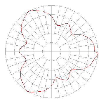
| Antenna Data for Antenna Id: 92297 KETZ DT File: BLEDT-20090615ABU Jampro - JHD-HV2-6/3(18) Service: DT Standard Pattern: Y |  | |||||||||||||||||||||||||||||||||||||||
| Azimuth | Ratio | Azimuth | Ratio | Azimuth | Ratio | Azimuth | Ratio | |||||||||||||||||||||||||||||||||
| 0 | 0.758 | 10 | 0.592 | 20 | 0.605 | 30 | 0.698 | |||||||||||||||||||||||||||||||||
| 40 | 0.634 | 50 | 0.570 | 60 | 0.725 | 70 | 0.851 | |||||||||||||||||||||||||||||||||
| 80 | 0.921 | 90 | 0.933 | 92 | 1.000 | 100 | 0.936 | |||||||||||||||||||||||||||||||||
| 110 | 0.869 | 120 | 0.758 | 130 | 0.592 | 140 | 0.605 | |||||||||||||||||||||||||||||||||
| 150 | 0.698 | 160 | 0.634 | 170 | 0.570 | 180 | 0.725 | |||||||||||||||||||||||||||||||||
| 190 | 0.851 | 200 | 0.921 | 210 | 0.993 | 212 | 1.000 | |||||||||||||||||||||||||||||||||
| 220 | 0.936 | 230 | 0.869 | 240 | 0.758 | 250 | 0.592 | |||||||||||||||||||||||||||||||||
| 260 | 0.605 | 270 | 0.698 | 280 | 0.634 | 290 | 0.570 | |||||||||||||||||||||||||||||||||
| 300 | 0.725 | 310 | 0.851 | 320 | 0.921 | 330 | 0.993 | |||||||||||||||||||||||||||||||||
| 332 | 1.000 | 340 | 0.936 | 350 | 0.869 | |||||||||||||||||||||||||||||||||||
Structure Registration Number 1039950 Structure Type: GTOWER Registered To: American Towers, LLC Structure Address: 412 Bolding Rd. (300489) Huttig, AR County Name: Union County ASR Issued: 02/07/2020 Date Built: 06/29/1987 Site Elevation: 39.6 m (130 ft.) Structure Height: 600.4 m (1970 ft.) Height Overall: 600.4 m (1970 ft.) Overall Height AMSL: 640 m (2100 ft.) FAA Determination: 06/04/2008 FAA Study #: 2008-ASW-3980-OE Paint & Light FAA Chapters: B, G, H PRIOR STUDY 2007-ASW-10306-OE 33-04-41.6 N 92-13-30.9 W (NAD 83) 33-04-41.1 N 92-13-30.4 W (Converted to NAD 27) |
350 S. Donaghey Conway, AR 72034 Phone: 501-682-2386 Government Entity | Date: 06/15/2009 Application Certifier Arkansas Educational Television Commission 350 S. Donaghey P.O. Box 1250 Conway, AR 72034 Applicant William R. Meintel Meintel, Sgrignoli & Wallace P.O. Box 907 Warrenton, VA 20188-0907 Consultant Todd D. Gray Dow Lohnes PLLC 1200 New Hampshire Ave. NW Suite 800 Washington, DC 20036 | ||||||||||||||||||||||||||||||||||||||
| ||||||||||||||||||||||||||||||||||||||||