|
K207CQ(FX)
Call Sign History
K207CQ from 08/12/2003
DK207CQ from 03/22/2002
K207CQ from 01/19/1999
980223TA from 02/23/1998
|
89.3 MHz
|
Gallup, NM
|
|
K207CQ Channel: 207D 89.3 MHz
Gallup, New Mexico
Service: FX - A translator or application for a translator.
Facility ID: 90091
FRN: 0002718062
Fac. Service: FX
Programming Delivery Method: Unspecified
Status: LIC
Application Accepted: 04/14/1999
Application Granted: 09/16/2003
File Number: BLFT-19990414TA
License Expires: 10/01/2029
Prefix Type: This is a license for a translator
Application Type: License To Cover
FCC Website Links:
LMS Facility Details
This Application
Other K207CQ Applications
Including Superseded Applications
Service Contour - Open Street Map or USGS Map (60 dBu)
Service Contour - KML / Google Earth (60 dBu)
Class: D, A Noncommercial educational operating with no more than 10W
Site Location: 35-32-26.1 N 108-44-38.3 W (NAD 83)
Site Location: 35-32-26.0 N 108-44-36.0 W (Converted to NAD 27)
Effective Radiated Power: 0 kW Horiz. ; 0.1 kW Vert.
Transmitter Output Power: 0.052 kW
Antenna Center AMSL: 0 m Horiz.; 2073 m Vert.
Antenna Center HAG: 0 m Horiz.; 23 m Vert.
Calculated Site Elevation: m.
Height Overall*: 25 m (82 ft.)
(* As Filed In This Application, may differ from ASR Data, Below.)
Directional Antenna
Antenna Make/Model: Scala FMV-2VV
Antenna ID: 16164
Polarization:
| Primary Station |
| KVCN(FM) |
Ch. 294 | Los Alamos, New Mexico |
|
Antenna Data for Antenna Id: 16164
K207CQ FX File: BLFT-19990414TA
Scala - FMV-2VV
Service: FX
Pattern and Field Values Include a 170° Clockwise Rotation
|
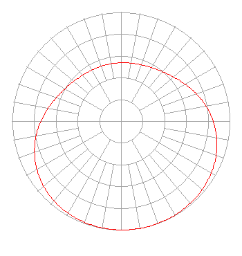 |
| Azimuth | Ratio | Azimuth | Ratio | Azimuth | Ratio | Azimuth | Ratio |
| 0 | 0.535 | 10 | 0.540 | 20 | 0.549 | 30 | 0.566 |
| 40 | 0.592 | 50 | 0.630 | 60 | 0.679 | 70 | 0.735 |
| 80 | 0.792 | 90 | 0.845 | 100 | 0.892 | 110 | 0.929 |
| 120 | 0.956 | 130 | 0.975 | 140 | 0.987 | 150 | 0.995 |
| 160 | 0.999 | 170 | 1.000 | 180 | 0.999 | 190 | 0.995 |
| 200 | 0.987 | 210 | 0.975 | 220 | 0.956 | 230 | 0.929 |
| 240 | 0.892 | 250 | 0.845 | 260 | 0.792 | 270 | 0.735 |
| 280 | 0.679 | 290 | 0.630 | 300 | 0.592 | 310 | 0.566 |
| 320 | 0.549 | 330 | 0.540 | 340 | 0.535 | 350 | 0.534 |
|
Structure Information
Structure Registration Number 1058752
[ASR Heights Differ from K207CQ Application]
Structure Type: TOWER
Registered To:
CHRISTIAN BROADCASTING ACADEMY INC
Structure Address:
1.41 Km Nnw Of Us 66 & Nm 32
Gallup, NM
County Name: McKinley County
ASR Issued: 12/14/1998
Site Elevation: 2048.6 m (6721 ft.)
Structure Height: 25.9 m (85 ft.)
Height Overall: 25.9 m (85 ft.)
Overall Height AMSL: 2074.5 m (6806 ft.)
FAA Determination: 07/15/1998
FAA Study #: 98-ASW-2764-OE
Paint & Light FAA Chapters: NONE
Removed expiration date from determination. Scenario 1./jjs/case#635066
35-32-26.0 N 108-44-38.0 W (NAD 83)
35-32-25.9 N 108-44-35.7 W
(Converted to NAD 27)
|
K207CQ(FX) Licensee Information
VCY America, Inc.
3434 W. Kilbourn Ave.
Milwaukee, WI 53208-3313
Phone: 414-935-3000
| 19990414TA Applicant Information
Date: 04/14/1999
Application Certifier
Christian Broadcasting Academy Inc.
Christian Broadcasting Academy Inc.
3107 Eubank N.E. Ste #2
Albuquerque, NM 87111
Applicant
|
Associated Land Mobile Licenses
|
| (No Records Found) |
| Associated Microwave Licenses
|
| (No Records Found) |
|
