|
KEZR Channel: 293B 106.5 MHz
San Jose, California
Service: FM - A full-service FM station or application.
Facility ID: 1176
FRN: 0022491476
Fac. Service: FM
Status: LIC
Application Accepted: 06/25/2008
Application Granted: 09/08/2008
File Number: BLH-20080625ABG
License Expires: 12/01/2029
Prefix Type: This is a license for a commercial FM station
Application Type: License To Cover
FCC Website Links:
LMS Facility Details
This Application
Other KEZR Applications
Including Superseded Applications
Service Contour - Open Street Map or USGS Map (54 dBu)
Service Contour - KML / Google Earth (54 dBu)
Public Inspection Files
Facility Type: FM STATION
Class: B, A Zone I or I-A station; with 25kW-50kW ERP and a class contour distance 39km-52km
Site Location: 37-12-31.8 N 121-46-30.8 W (NAD 83)
Site Location: 37-12-32.0 N 121-46-27.0 W (Converted to NAD 27)
Effective Radiated Power: 42 kW
Transmitter Output Power: 18.2 kW
Antenna Center HAAT: 163 m (535 ft.)
Antenna Center AMSL: 415 m (1362 ft.)
Antenna Center HAG: 70 m (230 ft.)
Calculated Site Elevation: 345 m. (1132 ft.)
Height Overall*: 92 m (302 ft.)
(* As Filed In This Application, may differ from ASR Data, Below.)
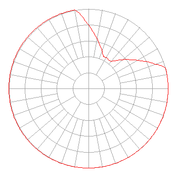
Directional Antenna
Antenna Make/Model: Electronics Research Inc. MP-6E-DA-HW, 6 sections, 0.5 wavelength spacing
Antenna ID: 83345
Polarization:
|
Structure Information
Structure Registration Number 1055723
Structure Type: LTOWER
Registered To:
American Towers LLC
Structure Address:
26060 Bernal Rd. (008113 / Coyote Peak)
San Jose, CA
County Name: Santa Clara County
ASR Issued: 12/30/2022
Date Built: 11/01/1996
Site Elevation: 345.3 m (1133 ft.)
Structure Height: 91.4 m (300 ft.)
Height Overall: 92 m (302 ft.)
Overall Height AMSL: 437.3 m (1435 ft.)
FAA Determination: 12/19/2022
FAA Study #: 2022-AWP-4871-OE
FAA Circular #: 70/7460-1K
Paint & Light FAA Chapters: 4, 6, 12
PRIOR STUDY 2015-AWP-7128-OE
37-12-32.1 N 121-46-31.0 W (NAD 83)
37-12-32.3 N 121-46-27.2 W
(Converted to NAD 27)
|
KEZR(FM) Licensee Information
Alpha Media Licensee LLC
180 Post Road East
Suite 201
Westport, CT 06880
Phone: 203-227-1978
Limited Liability Company | 20080625ABG Applicant Information
Matthew L. Leibowitz
Date: 06/25/2008
Application Certifier
NM Licensing LLC
6312 South Fiddlers Green Cir.
Suite 205-E
Greenwood Village, CO 80111
Applicant
Michael L. Stockwell
190 Park Center Plaza
Suite 200
San Jose, CA 95113
Chief Engineer
Joseph A. Belisle
Leibowitz & Associates
|