|
KRVG-FM1
Call Sign History
KRVG-FM1 from 07/19/2001
|
95.5 MHz
|
West Glenwood, CO
|
|
KRVG-FM1 Channel: 238D 95.5 MHz
West Glenwood, Colorado
Service: FB - A booster station or application for a booster.
Facility ID: 132921
FRN: 0004259552
Fac. Service: FB
Programming Delivery Method: Unspecified
Status: LIC
Application Accepted: 08/10/2001
Application Granted: 10/15/2001
File Number: BLFTB-20010806ACA
License Expires: 04/01/2021
Prefix Type: This is a license for a booster
Application Type: License To Cover
FCC Website Links:
LMS Facility Details
This Application
Other KRVG-FM1 Applications
Including Superseded Applications
Service Contour - Open Street Map or USGS Map (60 dBu)
Service Contour - KML / Google Earth (60 dBu)
Facility Type: FM STATION
Class: D, A Noncommercial educational operating with no more than 10W
Site Location: 39-33-39.9 N 107-19-01.2 W (NAD 83)
Site Location: 39-33-40.0 N 107-18-59.0 W (Converted to NAD 27)
Effective Radiated Power: 0 kW Horiz. ; 0.5 kW Vert.
Transmitter Output Power: 0.235 kW
Antenna Center HAAT: 0 m
Antenna Center AMSL: 0 m Horiz.; 2219 m Vert.
Antenna Center HAG: 0 m Horiz.; 8 m Vert.
Site Elevation: 2211 m. (7254 ft.)
Height Overall*: 11.9 m (39 ft.)
(* As Filed In This Application, may differ from ASR Data, Below.)
Directional Antenna
Antenna Make/Model: None
Antenna ID: 39557
Polarization:
| Primary Station |
| KRVG(FM) |
Ch. 238 | Glenwood Springs, Colorado |
|
Antenna Data for Antenna Id: 39557
KRVG-FM1 FB File: BLFTB-20010806ACA
None -
Service: FB
|
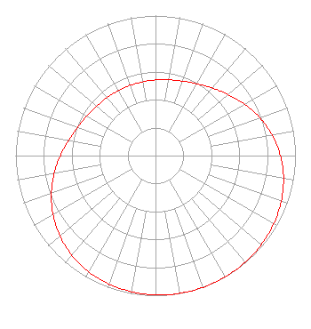 |
| Azimuth | Ratio | Azimuth | Ratio | Azimuth | Ratio | Azimuth | Ratio |
| 0 | 0.540 | 10 | 0.549 | 20 | 0.566 | 30 | 0.592 |
| 40 | 0.630 | 50 | 0.679 | 60 | 0.735 | 70 | 0.792 |
| 80 | 0.845 | 90 | 0.892 | 100 | 0.929 | 110 | 0.956 |
| 120 | 0.975 | 130 | 0.987 | 140 | 0.995 | 150 | 0.999 |
| 160 | 1.000 | 170 | 0.999 | 180 | 0.995 | 190 | 0.987 |
| 200 | 0.975 | 210 | 0.956 | 220 | 0.929 | 230 | 0.892 |
| 240 | 0.845 | 250 | 0.792 | 260 | 0.735 | 270 | 0.679 |
| 280 | 0.630 | 290 | 0.592 | 300 | 0.566 | 310 | 0.549 |
| 320 | 0.540 | 330 | 0.535 | 340 | 0.534 | 350 | 0.535 |
|
Structure Information
Structure Registration Number 1208423
[ASR Heights Differ from KRVG-FM1 Application]
Structure Type: B
Registered To:
Town of Bristol
Structure Address:
230 Lake Street
Bristol, NH
County Name: Grafton County
ASR Issued: 01/12/2000
Site Elevation: 146 m (479 ft.)
Structure Height: 9 m (30 ft.)
Height Overall: 15 m (49 ft.)
Overall Height AMSL: 161 m (528 ft.)
FAA Determination: 04/09/1992
FAA Study #: 116741-NH
FAA Circular #:
Paint & Light FAA Chapters: NONE
43-35-46.2 N 71-44-38.2 W (NAD 83)
43-35-45.9 N 71-44-39.9 W
(Converted to NAD 27)
|
KRVG-FM1 Licensee Information
Western Slope Communications, L.L.C.
751 Horizon Ct Ste 200
Grand Junction, CO 81506
| 20010806ACA Applicant Information
Allen H. Brill
Date: 08/06/2001
Application Certifier
Western Slope Communications, LLC
C/O Brill & Meisel
488 Madison Avenue
New York, NY 10022
Applicant
See Paper Form
|
Associated Land Mobile Licenses
|
| (No Records Found) |
| Associated Microwave Licenses
|
| (No Records Found) |
|
