FCCInfo.com
A Service of Cavell, Mertz & Associates, Inc.
(855) FCC-INFO
|
|
KAZG from 12/19/1997 950815KE from ??? |
Virtual Channel 24 |
|
||||||||||||||||||||||
|
|
Status: LIC Application Accepted: 06/17/2009 License Expires: 10/01/2030 File Number: BLCDT-20090617ABF Prefix Type: This is a License for a commercial digital TV station FCC Website Links: LMS Facility Details This Application Other KPNZ Applications Including Superseded Applications Service Contour - Open Street Map or USGS Map (41 dBu) Service Contour - KML / Google Earth (41 dBu) Public Inspection Files Rabbit Ears Info Search for KPNZ Site Location: 40-39-33.0 N 112-12-10.0 W (NAD 83) Site Location: 40-39-33.2 N 112-12-07.2 W (Converted to NAD 27) ERP: 450 kW Polarization: Horizontally polarized HAAT: 1229 m (4032 ft.) Electrical Beam Tilt: 1.5 degrees R/C AGL: 60 m (197 ft.) R/C AMSL: 2814 m (9232 ft.) Site Elevation: 2754 m. (9035 ft.) Height Overall*: 94 m (308 ft.) (* As Filed In This Application, may differ from ASR Data, Below.) Directional Antenna - Antenna Make/Model: DIELECTRIC TUP-T3-12-1 Antenna ID: 87064 Polarization: Horizontally polarized | ||||||||||||||||||||||||
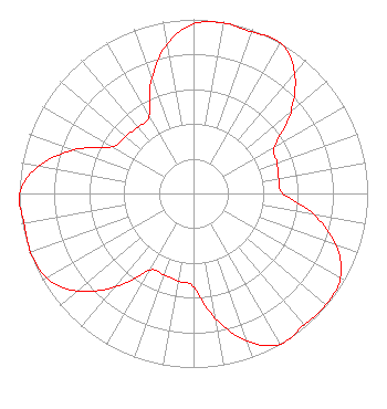
| Antenna Data for Antenna Id: 87064 KPNZ DT File: BLCDT-20090617ABF DIELECTRIC - TUP-T3-12-1 Service: DT Standard Pattern: Y |  | ||||||||||||||||||||||||
| Azimuth | Ratio | Azimuth | Ratio | Azimuth | Ratio | Azimuth | Ratio | ||||||||||||||||||
| 0 | 0.973 | 10 | 0.994 | 20 | 0.987 | 30 | 1.000 | ||||||||||||||||||
| 40 | 0.903 | 50 | 0.730 | 60 | 0.538 | 70 | 0.511 | ||||||||||||||||||
| 80 | 0.497 | 90 | 0.512 | 100 | 0.703 | 110 | 0.873 | ||||||||||||||||||
| 120 | 0.973 | 130 | 0.994 | 140 | 0.987 | 150 | 1.000 | ||||||||||||||||||
| 160 | 0.903 | 170 | 0.730 | 180 | 0.538 | 190 | 0.511 | ||||||||||||||||||
| 200 | 0.497 | 210 | 0.512 | 220 | 0.703 | 230 | 0.873 | ||||||||||||||||||
| 240 | 0.973 | 250 | 0.994 | 260 | 0.987 | 270 | 1.000 | ||||||||||||||||||
| 280 | 0.903 | 290 | 0.730 | 300 | 0.538 | 310 | 0.511 | ||||||||||||||||||
| 320 | 0.497 | 330 | 0.512 | 340 | 0.703 | 350 | 0.873 | ||||||||||||||||||
Structure Registration Number 1062408 Structure Type: TOWER Registered To: DTV Utah, LC Structure Address: Farnsworth Peak, 10 Kilometers Sw Of Magna Salt Lake City, UT County Name: Salt Lake County ASR Issued: 11/05/2020 Date Built: 10/28/1999 Site Elevation: 2754 m (9035 ft.) Structure Height: 94 m (308 ft.) Height Overall: 94 m (308 ft.) Overall Height AMSL: 2848 m (9344 ft.) FAA Determination: 03/11/1999 FAA Study #: 99-ANM-0178-OE FAA Circular #: 70/7460-1J Paint & Light FAA Chapters: 4, 8, 13 Removed expiration date from determination. Scenario 1./jjs/case#635066 40-39-33.0 N 112-12-10.0 W (NAD 83) 40-39-33.2 N 112-12-07.2 W (Converted to NAD 27) |
Marion, IL 62959 Phone: 618-997-4700 Not-for-Profit | Date: 06/17/2009 Application Certifier KRCA License LLC 1845 Empire Avenue Burbank, CA 91504 Applicant Joseph M. Davis, P.E. Chesapeake RF Consultants, LLC 11993 Kahns Road Manassas, VA 20112 Consulting Engineer Marnie K. Sarver Wiley Rein LLP 1776 K Street, NW Washington, DC 20006 | |||||||||||||||||||||||
| |||||||||||||||||||||||||