FCCInfo.com
A Service of Cavell, Mertz & Associates, Inc.
(855) FCC-INFO
|
|
840420KU from ??? |
Virtual Channel 45 |  |
|
||||||||||||||||||||||||||||||||||||||
|
|
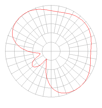
Status: LIC Application Accepted: 06/25/2013 License Expires: 10/01/2030 File Number: BLCDT-20130625AAK Prefix Type: This is a License for a commercial digital TV station FCC Website Links: LMS Facility Details This Application Other KUTP Applications Including Superseded Applications Service Contour - Open Street Map or USGS Map (41 dBu) Service Contour - KML / Google Earth (41 dBu) Public Inspection Files Rabbit Ears Info Search for KUTP Site Location: 33-20-03.3 N 112-03-43.2 W (NAD 83) Site Location: 33-20-03.1 N 112-03-40.7 W (Converted to NAD 27) ERP: 1000 kW Polarization: Horizontally polarized HAAT: 531.5 m (1744 ft.) Electrical Beam Tilt: 1 degree R/C AGL: 88 m (289 ft.) R/C AMSL: 897.2 m (2944 ft.) Site Elevation: 809.2 m. (2655 ft.) Height Overall*: 114.9 m (377 ft.) (* As Filed In This Application, may differ from ASR Data, Below.) Directional Antenna - Antenna Make/Model: DIELECTRIC TFU-20DCS-R CT150 Antenna ID: 113722 Polarization: Horizontally polarized
| |||||||||||||||||||||||||||||||||||||||||
| Antenna Data for Antenna Id: 113722 KUTP DT File: BLCDT-20130625AAK DIELECTRIC - TFU-20DCS-R CT150 Service: DT Standard Pattern: Y |  | |||||||||||||||||||||||||||||||||||||||||
| Azimuth | Ratio | Azimuth | Ratio | Azimuth | Ratio | Azimuth | Ratio | |||||||||||||||||||||||||||||||||||
| 0 | 0.879 | 10 | 0.867 | 20 | 0.884 | 30 | 0.916 | |||||||||||||||||||||||||||||||||||
| 40 | 0.944 | 50 | 0.956 | 60 | 0.948 | 70 | 0.923 | |||||||||||||||||||||||||||||||||||
| 80 | 0.890 | 90 | 0.868 | 100 | 0.874 | 110 | 0.910 | |||||||||||||||||||||||||||||||||||
| 120 | 0.954 | 130 | 0.987 | 140 | 1.000 | 150 | 0.994 | |||||||||||||||||||||||||||||||||||
| 160 | 0.969 | 170 | 0.905 | 180 | 0.772 | 190 | 0.557 | |||||||||||||||||||||||||||||||||||
| 200 | 0.305 | 210 | 0.205 | 220 | 0.425 | 230 | 0.518 | |||||||||||||||||||||||||||||||||||
| 240 | 0.455 | 250 | 0.281 | 260 | 0.266 | 270 | 0.506 | |||||||||||||||||||||||||||||||||||
| 280 | 0.735 | 290 | 0.885 | 300 | 0.960 | 310 | 0.991 | |||||||||||||||||||||||||||||||||||
| 320 | 1.000 | 330 | 0.991 | 340 | 0.962 | 350 | 0.918 | |||||||||||||||||||||||||||||||||||
Structure Registration Number 1002348 Structure Type: LTOWER Registered To: Fox Television Stations, LLC Structure Address: Approx 13.4 Km S On South Moutain Park Phoenix, AZ County Name: Maricopa County ASR Issued: 08/12/2015 Date Built: 05/13/2013 Site Elevation: 809.2 m (2655 ft.) Structure Height: 96.8 m (318 ft.) Height Overall: 114.9 m (377 ft.) Overall Height AMSL: 924.1 m (3032 ft.) FAA Determination: 05/02/2013 FAA Study #: 2013-AWP-1528-OE Paint & Light FAA Chapters: 1, 3, 12, 21 PRIOR STUDY 1985-AWP-152-OE 33-20-03.3 N 112-03-43.2 W (NAD 83) 33-20-03.1 N 112-03-40.7 W (Converted to NAD 27) |
101 Constitution Avenue, NW Suite 200 West Washington, DC 20001 Phone: 202-824-6503 Limited Liability Company | Date: 06/25/2013 Application Certifier Fox Television Stations, Inc. Fox Television Stations, LLC 444 North Capitol Street, NW Suite 740 Washington, DC 20001 Applicant Kevin T. Fisher 2237 Tacketts Mill Drive Suite A Lake Ridge, VA 22192 Engineering Consultant Joseph M. Di Scipio Fox Television Stations, Inc. 444 North Capitol Street, NW Suite 740 Washington, DC 20001 | ||||||||||||||||||||||||||||||||||||||||
|
| |||||||||||||||||||||||||||||||||||||||||