
FCCInfo.com
A Service of Cavell, Mertz & Associates, Inc.
(855) FCC-INFO
|
|
W267BM from 03/06/2012 W267BM from 09/29/2011 W267BM from 12/18/2006 W267BM from 04/05/2004 |
|
|
||||||||||||||||
|
|
W267BM Channel: 267D 101.3 MHz Hawesville, Kentucky Service: FX - A translator or application for a translator. Facility ID: 144738 Fac. Service: FX Programming Delivery Method: Unspecified Status: LIC Application Accepted: 05/31/2019 Application Granted: 06/05/2019 File Number: BLFT-20190531AAR Prefix Type: This is a license for a translator Application Type: License To Cover FCC Website Links: LMS Facility Details This Application CDBS Application Other W267BM Applications Other W267BM Applications in CDBS Including Superseded Applications Mailing Address Correspondence for W267BM Correspondence related to application BLFT-20190531AAR Service Contour - Open Street Map or USGS Map (60 dBu) Service Contour - KML / Google Earth (60 dBu) Class: D, A Noncommercial educational operating with no more than 10W Site Location: 37-46-30.2 N 87-09-32.0 W (NAD 83) Site Location: 37-46-30.0 N 87-09-32.0 W (Converted to NAD 27) Effective Radiated Power: 0.25 kW Transmitter Output Power: 0.497 kW Antenna Center HAAT: 0 m Antenna Center AMSL: 230 m (755 ft.) Antenna Center HAG: 108 m (354 ft.) Site Elevation: 122 m. (400 ft.) Height Overall*: 123 m (404 ft.) (* As Filed In This Application, may differ from ASR Data, Below.) Directional Antenna Antenna Make/Model: None Antenna ID: 133056 Polarization:
| ||||||||||||||||||
| Antenna Data for Antenna Id: 133056 W267BM FX File: BLFT-20190531AAR None - Service: FX | 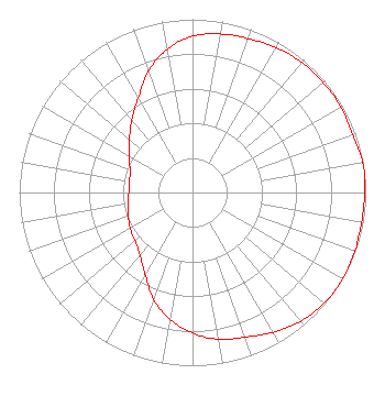 | ||||||||||||||||||
| Azimuth | Ratio | Azimuth | Ratio | Azimuth | Ratio | Azimuth | Ratio | ||||||||||||
| 0 | 0.902 | 10 | 0.929 | 20 | 0.945 | 30 | 0.966 | ||||||||||||
| 40 | 0.981 | 50 | 0.986 | 60 | 0.988 | 70 | 0.982 | ||||||||||||
| 80 | 0.999 | 90 | 0.995 | 100 | 0.990 | 110 | 0.996 | ||||||||||||
| 120 | 1.000 | 130 | 0.994 | 140 | 0.971 | 150 | 0.932 | ||||||||||||
| 160 | 0.889 | 170 | 0.860 | 180 | 0.811 | 190 | 0.744 | ||||||||||||
| 200 | 0.656 | 210 | 0.547 | 220 | 0.472 | 230 | 0.433 | ||||||||||||
| 240 | 0.415 | 250 | 0.395 | 260 | 0.378 | 270 | 0.368 | ||||||||||||
| 280 | 0.369 | 290 | 0.384 | 300 | 0.423 | 310 | 0.475 | ||||||||||||
| 320 | 0.545 | 330 | 0.628 | 340 | 0.745 | 350 | 0.840 | ||||||||||||
Structure Registration Number 1044742 Structure Type: LTOWER Registered To: Spectrum Mid-America, LLC Structure Address: 100 Industrial Drive - Tower 2 Owensboro, KY County Name: Daviess County ASR Issued: 06/08/2021 Date Built: 11/01/2007 Site Elevation: 121.9 m (400 ft.) Structure Height: 121.9 m (400 ft.) Height Overall: 123.4 m (405 ft.) Overall Height AMSL: 245.3 m (805 ft.) FAA Determination: 04/28/2021 FAA Study #: 2021-ASO-13577-OE FAA Circular #: 70/7460-1M Paint & Light FAA Chapters: 3, 4, 5, 15 PRIOR STUDY 2007-ASO-541-OE 37-46-30.4 N 87-09-32.2 W (NAD 83) 37-46-30.2 N 87-09-32.2 W (Converted to NAD 27) |
Nashville, TN 37215 Phone: 615-361-7560 Corporation | Date: 05/31/2019 Application Certifier HANCOCK COMMUNICATIONS, INC. Po Box 150846 Nashville, TN 37215-0846 Applicant CHARLES M. ANDERSON 1519 Euclid Avenue Bowling Green, KY 42103 CONSULTANT JOHN F. GARZIGLIA Womble Bond Dickinson (us) Llp 1200 19th Street, N.w. Suite 500 Washington, DC 20036 | |||||||||||||||||